Grande Prairie is a city in northwest Alberta, Canada within the southern portion of an area known as Peace River Country. It is located at the intersection of Highway 43 and Highway 40, approximately 456 km (283 mi) northwest of Edmonton. The city is surrounded by the County of Grande Prairie No. 1.

Leduc is a city in the province of Alberta, Canada. It is 33 kilometres (21 mi) south of the provincial capital of Edmonton and is part of the Edmonton Metropolitan Region.

Alberta is a Canadian province. Located in Western Canada, the province has an area of 661,190 square kilometres (255,290 sq mi) and is bounded to the south by the U.S. state of Montana along 49° north for 298 kilometres (185 mi); to the east at 110° west by the province of Saskatchewan for 1,223 kilometres (760 mi); and at 60° north the Northwest Territories for 644 kilometres (400 mi). The southern half of the province borders British Columbia along the Continental Divide of the Americas on the peaks of the Rocky Mountains, while the northern half borders British Columbia along the 120th meridian west.

Fort Chipewyan, commonly referred to as Fort Chip, is a hamlet in northern Alberta, Canada, within the Regional Municipality (RM) of Wood Buffalo. It is located on the western tip of Lake Athabasca, adjacent to Wood Buffalo National Park, approximately 223 kilometres (139 mi) north of Fort McMurray.
Jasper is a specialized municipality in western Alberta, Canada. It is the commercial centre of Jasper National Park, located in the Canadian Rockies within the Athabasca River valley. Jasper is approximately 362 kilometres (225 mi) west of Edmonton and 290 kilometres (180 mi) north of Banff, Alberta, at the intersection of Highway 16 and Highway 93.

Wood Buffalo National Park is the largest National Park of Canada at 44,807 km2 (17,300 sq mi). It is located in northeastern Alberta and the southern Northwest Territories. Larger in area than Switzerland, it is the second-largest national park in the world. The park was established in 1922 to protect the world's largest herd of free roaming wood bison, currently estimated at more than 5,000. It is one of two known nesting sites of whooping cranes.

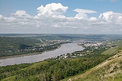
Peace River, originally named Peace River Crossing, and known as Rivière-la-Paix in French, is a town in northwestern Alberta, Canada, situated along the banks of the Peace River, at its confluence with the Smoky River, the Heart River and Pat's Creek. It is located 486 kilometres (302 mi) northwest of Edmonton, and 198 kilometres (123 mi) northeast of Grande Prairie, along Highway 2. It was known as the Village of Peace River Crossing between 1914 and 1916.

Red Deer County is a municipal district in central Alberta, Canada within Census Division No. 8 and surrounding the City of Red Deer. The neighbouring municipalities of Red Deer County are Clearwater County to the west, Lacombe County to the north, the County of Stettler No. 6 to the east, Kneehill County to the southeast and Mountain View County to the south. It is located approximately midway between Edmonton and Calgary, bisected by the Queen Elizabeth II Highway and bounded on the north and east by the Red Deer River.

The Peace River Country is an aspen parkland region centring on the Peace River in Canada. It extends from northwestern Alberta to the Rocky Mountains in northeastern British Columbia, where a certain portion of the region is also referred to as the Peace River Block.

The Edmonton Metropolitan Region (EMR), also commonly referred to as the Alberta Capital Region, Greater Edmonton or Metro Edmonton, is a conglomeration of municipalities centred on Alberta's provincial capital of Edmonton.

Valleyview is a town in northwest Alberta, Canada within the Municipal District of Greenview No. 16 and Census Division No. 18.

The Municipal District of Greenview No. 16 is a municipal district in northwest Alberta, Canada.

The Municipal District of Peace No. 135 is a municipal district in northwestern Alberta, Canada. Located in Census Division No. 19, its municipal office is located outside but adjacent to the Village of Berwyn.

The Municipal District of Spirit River No. 133 is a municipal district in northwest Alberta, Canada, north of Grande Prairie. Located in the Upper Peace Region, its municipal office is located in the Town of Spirit River.

Western Canada, also referred to as the Western provinces and more commonly known as the West, is a region of Canada that includes the four provinces of Manitoba, Saskatchewan, Alberta and British Columbia. British Columbia is culturally, economically, geographically, and politically distinct from the other parts of Western Canada and is often referred to as the "west coast" or "Pacific Canada", while Alberta, Saskatchewan, and Manitoba are grouped together as the Prairie Provinces and most commonly known as "The Prairies".

The Red Deer Region is a land-use framework region in Alberta, Canada. One of seven in the province, each is intended to develop and implement a Regional Plan, complementing the planning efforts of member municipalities in order to coordinate future growth. Corresponding roughly to major watersheds while following municipal boundaries, these regions are managed by Alberta Environment and Parks.
The Lower Peace Region is a land-use framework region in northern Alberta, Canada. One of seven in the province, each is intended to develop and implement a Regional Plan, complementing the planning efforts of member municipalities in order to coordinate future growth. Corresponding roughly to major watersheds while following municipal boundaries, these regions are managed by Alberta Environment and Parks.