Related Research Articles

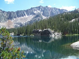
Little Redfish Lake in central Idaho is in the Sawtooth National Recreation Area and Custer County.

Sawtooth National Forest is a National Forest that covers 2,110,408 acres in the U.S. states of Idaho and Utah. Managed by the U.S. Forest Service in the U.S. Department of Agriculture, it was originally named the Sawtooth Forest Reserve in a proclamation issued by President Theodore Roosevelt on May 29, 1905. On August 22, 1972 a portion of the forest was designated as the Sawtooth National Recreation Area (SNRA), which includes the Sawtooth, Cecil D. Andrus–White Clouds, and Hemingway–Boulders wilderness areas. The forest is managed as four units: the SNRA and the Fairfield, Ketchum, and Minidoka Ranger Districts.

The Sawtooth National Recreation Area (SNRA) is a national recreation area in central Idaho, United States that is managed as part of Sawtooth National Forest. The recreation area, established on August 22, 1972, is managed by the U.S. Forest Service, and includes the Sawtooth, Hemingway–Boulders, and Cecil D. Andrus–White Clouds wilderness areas. Activities within the 730,864-acre (2,957.70 km2) recreation area include hiking, backpacking, White water rafting, camping, rock climbing, kayaking, mountain biking, fishing, and hunting.

The Sawtooth Range is a mountain range of the Rocky Mountains in central Idaho, United States, reaching a maximum elevation of 10,751 feet (3,277 m) at the summit of Thompson Peak. It encompasses an area of 678 square miles (1,756 km2) spanning parts of Custer, Boise, Blaine, and Elmore counties, and is bordered to the east by the Sawtooth Valley. Much of the mountain range is within the Sawtooth Wilderness, part of the Sawtooth National Recreation Area and Sawtooth National Forest.

Thompson Peak, at 10,751 feet (3,277 m) above sea level is the highest peak in the Sawtooth Range of Idaho. The summit of Thompson Peak is located within Custer County, although some of the lower portion of the mountain is in Boise County. Thompson Peak is also located within the Sawtooth Wilderness portion of the Sawtooth National Recreation Area, a unit of Sawtooth National Forest. The town of Stanley, Idaho is about 6 miles (9.7 km) northeast of Thompson Peak.

Mount Heyburn, at 10,229 feet (3,118 m) is one of the many 10,000-foot (3,050 m) peaks in the Sawtooth Range of central Idaho. Mount Heyburn is located in Custer County and within the Sawtooth Wilderness portion of the Sawtooth National Recreation Area. The town of Stanley is located eight miles (13 km) north-northeast of Mount Heyburn. Grand Mogul, 9,733 ft (2,967 m), and Mount Heyburn are the two signature peaks that frame the southwest end of Redfish Lake ; all are in the Salmon River watershed.

Sawtooth Lake is an alpine lake in Custer County, Idaho, United States, located high in the Sawtooth Mountains in the Sawtooth National Recreation Area. The lake is approximately 6.8 miles (10.9 km) southwest of Stanley. A trail from the Iron Creek trailhead and campground leads approximately 5 miles to Sawtooth Lake. The Iron Creek trailhead can be accessed from State Highway 21 via Sawtooth National Forest road 619.

Alpine Lake is an alpine lake in Custer County, Idaho, United States, located high in the Sawtooth Mountains in the Sawtooth National Recreation Area. The lake is approximately 11.4 miles (18.3 km) southwest of Stanley.

Edna Lake is an alpine lake in Boise County, Idaho, United States, located high in the Sawtooth Mountains in the Sawtooth National Recreation Area. The lake is approximately 17 miles (27 km) southwest of Stanley and 14.5 miles (23.3 km) southeast of Grandjean. Located in the remote central Sawtooth Wilderness, Edna Lake can be reached by trails from many directions, including the Sawtooth Valley (east), Grandjean (northwest), Redfish Lake (north), and Atlanta (south).
Vernon Lake is an alpine lake in Boise County, Idaho, United States, located high in the Sawtooth Mountains in the Sawtooth National Recreation Area. The lake is approximately 17 miles (27 km) southwest of Stanley and 14.5 miles (23.3 km) southeast of Grandjean. Located in the remote central Sawtooth Wilderness, Vernon Lake can be reached by trails from many directions, including the Sawtooth Valley (east), Grandjean (northwest), Redfish Lake (north), and Atlanta (south).

Virginia Lake is an alpine lake in Boise County, Idaho, United States, located high in the Sawtooth Mountains in the Sawtooth National Recreation Area. The lake is approximately 17 miles (27 km) southwest of Stanley and 14.5 miles (23.3 km) southeast of Grandjean. Located in the remote central Sawtooth Wilderness, Edna Lake can be reached by trails from many directions, including the Sawtooth Valley (east), Grandjean (northwest), Redfish Lake (north), and Atlanta (south).

Marshall Lake is a small alpine lake in Custer County, Idaho, United States, located in the Sawtooth Mountains in the Sawtooth National Recreation Area. Sawtooth National Forest trail 528 leads directly to Marshall Lake. The lakes is most easily accessed from the Redfish Lake or Stanley Ranger Station trailheads.

The Bench Lakes are a chain of five small alpine glacial lakes in Custer County, Idaho, United States, located in the Sawtooth Mountains in the Sawtooth National Recreation Area. A cutoff from Sawtooth National Forest trail 101 along Redfish Lake leads to the Bench Lakes. The lakes are drained by an unnamed stream that flows into Redfish Lake, Redfish Lake Creek, and eventually the Salmon River.
Little Redfish Lake in central Idaho is in the Sawtooth National Recreation Area and Custer County. Little Redfish Lake is in the Big Boulder Creek Watershed of the White Cloud Mountains.
Lake Kathryn is an alpine lake in Custer County, Idaho, United States, located in the Sawtooth Mountains in the Sawtooth National Recreation Area. There are no trails that lead to Lake Kathryn, although it is most easily accessed from Sawtooth National Forest trail 154 along Redfish Lake Creek.
The Saddleback Lakes are a chain of small alpine glacial lakes in Custer County, Idaho, United States, located in the Sawtooth Mountains in the Sawtooth National Recreation Area. The lakes are drained by an unnamed tributary of Redfish Lake Creek, which flows into the Salmon River. There are no trails that lead to the lakes, although they are most easily accessed from Sawtooth National Forest trail 154.

Lily Lake is a small alpine lake in Custer County, Idaho, United States, located in the Sawtooth Mountains in the Sawtooth National Recreation Area. The lake is just upstream of Redfish Lake and is named from the many water lilies that cover its surface. There is a trail leading from the southwest end of Redfish Lake to Lily Lake.
Lower Bead Lake is a small alpine lake in Boise County, Idaho, United States, located in the Sawtooth Mountains in the Sawtooth National Recreation Area. There are no trails leading to the lake or the Goat Creek drainage.
Upper Bead Lake is a small alpine lake in Boise County, Idaho, United States, located in the Sawtooth Mountains in the Sawtooth National Recreation Area. There are no trails leading to the lake or the Goat Creek drainage.
References
- ↑ Sawtooth National Forest. “Sawtooth National Forest” [map].1:126,720, 1”=2 miles. Twin Falls, Idaho: Sawtooth National Forest, United States Forest Service, 1998.