Bedford is a community of the Halifax Regional Municipality, in Nova Scotia, Canada.

HMCS Sackville is a Flower-class corvette that served in the Royal Canadian Navy and later served as a civilian research vessel. She is now a museum ship located in Halifax, Nova Scotia, and the last surviving Flower-class corvette.

Lower Sackville is a community within the urban area of Halifax Regional Municipality, in Nova Scotia, Canada.
Middle Sackville is a suburban community located in Halifax Regional Municipality in Nova Scotia, Canada. It was named after George Germain, 1st Viscount Sackville.

Highway 107 in Nova Scotia runs through the eastern suburbs of the Halifax Regional Municipality, from the Burnside Industrial Park in Dartmouth to an intersection with Trunk 7 in Musquodoboit Harbour. It is 43.2 km (26.8 mi) long, and is mostly two lane, controlled access highway.

Trunk 1 is part of the Canadian province of Nova Scotia's system of Trunk Highways.
The Lighthouse Route is a scenic roadway in the Canadian province of Nova Scotia. It follows the province's South Shore for 585 km (364 mi) from Halifax to Yarmouth.

Ecum Secum is a rural community on the Eastern Shore of Nova Scotia, Canada, located in both the Halifax Regional Municipality and Guysborough County. Located along the shores of Ecum Secum Harbour, an inlet of the Atlantic Ocean, the community is located roughly 46 km (29 mi) east of Sheet Harbour, Nova Scotia, 37 km (23 mi) southwest of Sherbrooke, Nova Scotia, and approximately 160 km (99 mi) east of Downtown Halifax along the Marine Drive on Trunk 7. Several communities along the western shore of the harbour also share the name, including Ecum Secum Bridge and Ecum Secum West. The name of the community is derived from the Mi'kmaq language and means "a red house". The first Europeans to settle in the Ecum Secum area were Loyalists during the 1780s.
West Lawrencetown is a residential community within the Halifax Regional Municipality Nova Scotia on the Eastern Shore on Route 207 along the scenic route Marine Drive.
Head of Chezzetcook is a rural community on the Eastern Shore Marine Drive route of Halifax Regional Municipality in Nova Scotia. The Head of Chezzetcook area begins at the intersections of routes 7 and 207, near Porters Lake and West Chezzetcook, and continues along the Marine Drive to Gaetz Brook. Head of Chezzetcook is a short commute to Downtown Halifax at 29.52 kilometers; and in its heyday was a major port of call for ships delivering supplies from the city to local gold miners and early settlers. A vista of the sea marks the Head of Chezzetcook Inlet, for which the Chezzetcooks are named; and a fork in the road for both East Chezzetcook and Conrod Settlement.

Halifax Regional Fire and Emergency Services provides fire protection, rescue and first responder assistance throughout Halifax, Nova Scotia, Canada.

Lawrencetown is a Canadian rural community in the Halifax Regional Municipality in Nova Scotia, Canada. The settlement was established during the eve of Father Le Loutre's War and at the beginning of the French and Indian War.

The Halifax Waterfront Boardwalk is a public footpath located on the Halifax Harbour waterfront in Halifax, Nova Scotia, Canada.

The Sackville River is a river in Hants County and Halifax Regional Municipality, Nova Scotia, Canada. It empties into Bedford Basin. The Little Sackville River is a tributary.
Lewis Lake, Nova Scotia could mean the following:
Pockwock is one of four Black Nova Scotian settlements in Upper Hammonds Plains. People in this area are mostly descendants of War of 1812 refugees. It is located in the Halifax Regional Municipality in the Canadian province of Nova Scotia. The Halifax Regional Water Commission uses Pockwock Lake as a source for water for the communities of Halifax, Bedford and Lower Sackville.

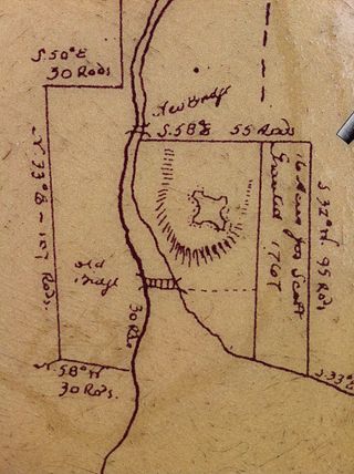
Fort Sackville was a British fort in present-day Bedford, Nova Scotia. It was built during Father Le Loutre's War by British adjacent to present-day Scott Manor House, on a hill overlooking the Sackville River to help prevent French, Acadian and Mi'kmaq attacks on Halifax. The fort consisted of a blockhouse, a guard house, a barracks that housed 50 soldiers, and outbuildings, all encompassed by a palisade. Not far from the fort was a rifle range. The fort was named after George Germain, 1st Viscount Sackville.
Route 940 is a 35.2-kilometre (21.9 mi) long north to south secondary highway in the southeastern portion of New Brunswick, Canada.
Upper Hammonds Plains is a Canadian suburban community located in Nova Scotia's Halifax Regional Municipality.

A township in Nova Scotia, Canada, was an early form of land division and local administration during British colonial settlement in the 18th century. They were created as a means of populating the colony with people loyal to British rule. They were typically rural or wilderness areas of around 100,000 acres (400 km2) that would eventually include several villages or towns. Some townships, but not all, returned a member to the General Assembly of Nova Scotia; others were represented by the members from the county. Townships became obsolete by 1879 by which time towns and counties had become incorporated.


