Upton Heath

Last updated

Typical countryside on Upton Heath Upton Heath Nature Reserve - geograph.org.uk - 453098.jpg
Typical countryside on Upton Heath

Upton Heath is one of the largest remaining fragments of a heath that once stretched across central southern England from Dorchester to Christchurch and beyond. It is now confined to an area immediately west of Upton and Poole, much of which is protected. [1] From the Heath there are views across Poole Harbour, Corfe Castle and the Isle of Purbeck. [2]

Contents

Geography

Upton Heath is part of the natural region of the Dorset Heaths and covers an area of 205 hectares. It lies within the Poole Basin and is bounded by the village of Corfe Mullen to the north, the Poole district of Broadstone to the northeast, Creekmoor to the east, the A35 dual carriageway to the south and the hamlet of Beacon Hill to the southwest. Lytchett Matravers lies about 4 kilometres to the west beyond Lychett Heath and the village of Upton lies to the south over the other side of the A35. The highest point on Upton Heath is the trig point at SY983956, which has extensive views to the south. [3]

Nature Reserve

Upton Heath looking towards Poole Harbour Upton Heath looking towards Poole Harbour.JPG
Upton Heath looking towards Poole Harbour
Old sandpit on Upton Heath Upton Heath, old sandpit - geograph.org.uk - 1516214.jpg
Old sandpit on Upton Heath

Much of the area has been designated as the Upton Heath Nature Reserve and is largely managed by the Dorset Wildlife Trust. [1] It is wild, wet and generally unsuitable for building which is why it was not developed as Poole expanded. [4] However abandoned sand pits and clay pits reflect its historic use for the pottery and brick making industries. [5]

Fauna and flora

Of particular interest on the heath are its reptiles – all six native British reptile species are found in the dry areas of the heath: the adder, grass snake, smooth snake, slowworm, viviparous lizard and sand lizard. Resident birds include the European stonechat, European nightjar, and rare Dartford warbler. In addition, the boggy areas support many dragonfly species as well as carnivorous round-leaved sundew and raft spiders. Local butterflies including the silver-studded blue and grayling. Amongst the rare flowering plants on the reserve are the marsh gentian and Dorset heath. [1] [5]

Heath fires

In June 2011, one third of the heath was devastated by what one source described as the "worst fire at Upton Heath for 35 years". [6] Local people had to evacuate their homes and 200 firefighters were engaged as the fire spread rapidly over a square kilometre. Dorset Wildlife Trust said that the fire had happened at the peak of the bird and reptile breeding season and had put wildlife development back 25 years. Two men believed to be responsible for starting the fire were being sought by police and the Crimestoppers offered a reward. [7] [8] [9]

In the aftermath of the Upton Heath Fire, an organisation called Heathwatch was formed with local people volunteering to act as wardens. [10] Two men, wanted by police, were arrested as a result of the initiative. [11]

On 5 August 2022, a wildfire broke out on Upton Heath. [12] Investigators believe the fire was started deliberately. [13]

Access

There is a public car park just northeast of the trig point. Otherwise access is limited due to the difficult terrain. There are public footpaths along the perimeter of the heath and one along the line of the dismantled railway in the south of the area. [3] [5]

Trail leaflets describing walks on the heath are available from Dorset Wildlife Trust. [1]

Related Research Articles

<span class="mw-page-title-main">Poole</span> Town in England

Poole is a coastal town and seaport on the south coast of England in the Bournemouth, Christchurch and Poole unitary authority area in Dorset, England. The town is 21 miles (34 km) east of Dorchester and adjoins Bournemouth to the east. Since 1 April 2019, the local authority is Bournemouth, Christchurch and Poole Council. The town had an estimated population of 151,500 making it the second-largest town in the ceremonial county of Dorset. Together with Bournemouth and Christchurch, the conurbation has a total population of nearly 400,000.

<span class="mw-page-title-main">Studland</span> Human settlement in England

Studland is a village and civil parish on the Isle of Purbeck in Dorset, England. The village is located about 2 miles (3.2 km) north of the town of Swanage, over a steep chalk ridge, and 3 miles (4.8 km) south of the South East Dorset conurbation at Sandbanks, from which it is separated by Poole Harbour. The parish includes Brownsea Island within the harbour. In the 2011 census the parish had 182 households and a population of 425, though many of the houses in the village are holiday homes, second homes, or guest houses, and the village's population varies depending upon the season.

<span class="mw-page-title-main">Studland and Godlingston Heath National Nature Reserve</span>

The Studland and Godlingston Heaths NNR is located on the Isle of Purbeck in the English county of Dorset. It borders Studland Bay on the south side of Poole Harbour, between the settlements of Swanage and Sandbanks. Extending to 631ha, it is owned and managed by the National Trust following the Bankes bequest of the Kingston Lacy estate. Studland & Godlingston Heath is designated as one of only 35 "spotlight reserves" in England by Natural England in the list of national nature reserves in England and is listed as a Site of Special Scientific Interest (SSSI).

<span class="mw-page-title-main">Lytchett Minster</span> Village in Dorset, England

Lytchett Minster is a village in Dorset, England. It lies around 4 miles (6.4 km) north-west of Poole town centre. The village forms part of the civil parish of Lytchett Minster and Upton, Upton now being a suburb of Poole.

Dorset Wildlife Trust (DWT) is a wildlife trust covering the county of Dorset, United Kingdom. The trust was founded in 1961 as Dorset Naturalists' Trust, to protect and conserve the wildlife and natural habitats of the county.

<span class="mw-page-title-main">Mid Dorset and North Poole (UK Parliament constituency)</span>

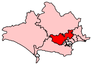
Mid Dorset and North Poole is a constituency represented in the House of Commons of the UK Parliament since 2015 by Michael Tomlinson, a Conservative.

<span class="mw-page-title-main">Canford Heath</span> Human settlement in England

Canford Heath is a suburb and area of heathland in Poole, Dorset, known for being the largest heathland in Dorset, and the largest lowland heath in the UK. It is also the name of the housing development built on the heathland in the 1960s, 1970s and 1980s. The area is split into two wards, and at the 2011 census the combined population of the two wards was 14,079.

<span class="mw-page-title-main">Beacon Hill, Dorset</span>

Beacon Hill is one of the highest viewpoints in the hinterland of Poole Harbour, Dorset. Its tree-covered summit reaches 84 metres (276 ft) above sea level and there is a public footpath running roughly north to south over the top. Historically it was one of a series of beacons used to warn of the advancing Spanish Armada. The earlier name for the hill was Lytchett Beacon.

<span class="mw-page-title-main">King Barrow Quarry</span> Disused quarry site

King Barrow Quarry is a disused site of former 19th century stone quarries on the Isle of Portland, Dorset, England. It is located in the north-east corner of Tophill. The quarry, now a Dorset Wildlife Trust nature reserve, covers 12.2 hectares. Both King Barrow and the nearby Tout Quarry make up the Dorset Wildlife Trust's Portland Quarries Nature Park. Portland also has two butterfly reserves: Broadcroft Quarry and Perryfield Quarry.

<span class="mw-page-title-main">Ferndown Common</span>

Ferndown Common is a Site of Special Scientific Interest (SSSI) on the edge of Ferndown in Dorset, England. It is currently owned by the Wimborne Estate and leased to the Amphibian and Reptile Conservation Trust (ARC), who manage it to preserve the site's rare wildlife. The site was notified as an SSSI in 1984.

<span class="mw-page-title-main">Parley Common</span>

Parley Common is a Site of Special Scientific Interest (SSSI) on the edge of Ferndown in Dorset, England. The majority land owner is the Canford Estate, but among the other owners are the Diocese of Salisbury, Dorset County Council, East Dorset District Council and a few private individuals. Most of the site is managed by the Amphibian and Reptile Conservation Trust (ARC); East Dorset Countryside Management Service manage the area owned by East Dorset District Council and Dorset Countryside manage the area owned by Dorset County Council. The site was notified as an SSSI in 1983.

<span class="mw-page-title-main">Dorset Heaths</span>

The Dorset Heaths form an important area of heathland within the Poole Basin in southern England. Much of the area is protected.

<span class="mw-page-title-main">Hartland Moor</span>

Hartland Moor is a Site of Special Scientific Interest (SSSI) on the south side of Poole Harbour near the town of Wareham in Dorset, England. It consists of lowland heathland.

<span class="mw-page-title-main">Stonehill Down Nature Reserve</span>

The Stonehill Down Nature Reserve is a downland nature reserve on the Purbeck Hills in the county of Dorset, England. It is managed by the Dorset Wildlife Trust.

<span class="mw-page-title-main">Corfe Barrows Nature Park</span>

Corfe Barrows Nature Park comprises around nine natural areas, covering an area of 90 hectares, within the Borough of Poole that are being managed for the benefit of wildlife and people. It was designated as a nature park in June 2016.

<span class="mw-page-title-main">Holes Bay Nature Park</span>

Holes Bay Nature Park is a protected area, 286 hectares in size, on and around Holes Bay, an embayment of Poole Harbour within the Borough of Poole that is important for wildlife, especially wetland birds. It was designated a nature park in March 2015.

<span class="mw-page-title-main">Holes Bay</span>

Holes Bay is an intertidal embayment off Poole Harbour in the county of Dorset on the south coast of England. It lies mostly within the Borough of Poole and is close to Poole town centre. It is an important wetland bird haven.

<span class="mw-page-title-main">2020 Wareham Forest fire</span> Forest fire in England

The 2020 Wareham Forest fire was a wildfire in Wareham Forest, Dorset, in May 2020. It destroyed over 220 Hectares of the heathland, and was described "one of the most devastating fires in Dorset, in living memory" by Dorset and Wiltshire Fire and Rescue Service.

The Frome Valley Trail is a long-distance footpath in Dorset, England which follows the River Frome from Evershot to Dorchester and will, when completed, extend to Poole Harbour.

References

  1. 1 2 3 4 "Upton Heath Guide Map". www.dorsetforyou.com. Retrieved 6 September 2013.
  2. "Upton Heath". wildlifetrusts.org. Retrieved 6 September 2013.
  3. 1 2 Ordnance Survey 1:50,000 Landranger map series, No. 195
  4. "Upton Heath Nature Reserve". www.natureofdorset.co.uk. Retrieved 6 September 2013.
  5. 1 2 3 "Upton Heath Nature Reserve". www.dorsetwildlifetrust.org.uk. Retrieved 6 September 2013.
  6. "What's the future for Upton Heath?". www.wildlifenews.co.uk. Retrieved 6 September 2013.
  7. "Upton Heath fire "destroyed eco-system". bbc.co.uk. Retrieved 6 September 2013.
  8. "Upton Heath Devastated By Fire". www.purbeckgazette.co.uk. Retrieved 6 September 2013.
  9. "Reward offered after Upton Heath blaze". www.dorset.police.uk. Retrieved 6 September 2013.
  10. Upton Heathwatch launch at dorsetwildlifetrust.org.uk. Retrieved 6 September 2013
  11. Dorset Wildlife Trust – Heathwatch at dorsetwildlifetrust.org.uk. Retrieved 6 September 2013
  12. "Fire breaks out at Upton Heath nature reserve in Dorset". BBC News. 4 August 2022. Retrieved 5 August 2022.
  13. "Road closures and cattle evacuations as 'deliberate' wildfire hits heathland". Dorset Echo. Retrieved 5 August 2022.

50°45′00″N2°01′19″W / 50.750°N 2.022°W / 50.750; -2.022