Utah, Indiana

Last updated

Utah is a populated location in Dearborn County, Indiana, in the United States. [1]

Dearborn County, Indiana County in the United States

Dearborn County is one of 92 counties of the U.S. state of Indiana located on the Ohio border near the southeast corner of the state. It was formed in 1803 from a portion of Hamilton County, Ohio. In 2010, the population was 50,047. The county seat and largest city is Lawrenceburg.

United States Federal republic in North America

The United States of America (USA), commonly known as the United States or America, is a country composed of 50 states, a federal district, five major self-governing territories, and various possessions. At 3.8 million square miles, the United States is the world's third or fourth largest country by total area and is slightly smaller than the entire continent of Europe's 3.9 million square miles. With a population of over 327 million people, the U.S. is the third most populous country. The capital is Washington, D.C., and the largest city by population is New York City. Forty-eight states and the capital's federal district are contiguous in North America between Canada and Mexico. The State of Alaska is in the northwest corner of North America, bordered by Canada to the east and across the Bering Strait from Russia to the west. The State of Hawaii is an archipelago in the mid-Pacific Ocean. The U.S. territories are scattered about the Pacific Ocean and the Caribbean Sea, stretching across nine official time zones. The extremely diverse geography, climate, and wildlife of the United States make it one of the world's 17 megadiverse countries.

History

It was likely named in commemoration of the Utah Territory. [2]

Utah Territory territory of the USA between 1850-1896

The Territory of Utah was an organized incorporated territory of the United States that existed from September 9, 1850, until January 4, 1896, when the final extent of the territory was admitted to the Union as the State of Utah, the 45th state.

Related Research Articles

Middleboro, Indiana Unincorporated community in Indiana, United States

Middleboro is an unincorporated community in Wayne Township, Wayne County, Indiana near the city of Richmond.

Butter Pot Provincial Park

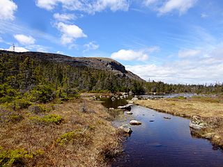
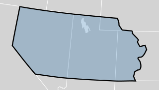
Butter Pot Provincial Park is a Provincial Park on the Avalon Peninsula of the island of Newfoundland. The park covers an area of approximately 28 km² and is located on the Trans-Canada Highway about 35 km southwest of St. John's. The park is named for a prominent rounded hill inside the park boundary. Butter Pot incorporates both day-use and overnight camping facilities, and in winter months provides groomed cross-country ski trails.

Randolph Township, Ohio County, Indiana Township in Indiana, United States

Randolph Township is one of four townships in Ohio County, Indiana, United States. As of the 2010 census, its population was 4,383 and it contained 2,033 housing units.

Brownsville Township, Union County, Indiana Township in Indiana, United States

Brownsville Township is one of six townships in Union County, Indiana, United States. As of the 2010 census, its population was 845 and it contained 351 housing units.

Center Township, Union County, Indiana Township in Indiana, United States

Center Township is one of six townships in Union County, Indiana, United States. As of the 2010 census, its population was 3,048 and it contained 1,330 housing units.

Wayne Township, Wayne County, Indiana Township in Indiana, United States

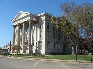
Wayne Township is one of fifteen townships in Wayne County, Indiana, United States. As of the 2010 census, its population was 41,217 and it contained 19,510 housing units.

Webster Township, Wayne County, Indiana Township in Indiana, United States

Webster Township is one of fifteen townships in Wayne County, Indiana, United States. As of the 2010 census, its population was 1,272 and it contained 552 housing units.

Dune Park station train station in Indiana

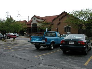
Dune Park is a station in Westchester Township, Porter County, Indiana, located north of the municipalities of Chesterton and Porter. It is used by South Shore Line trains, and serves as the headquarters of the Northern Indiana Commuter Transportation District (NICTD), the umbrella agency that operates the South Shore Line. It is located at the intersection of U.S. Highway 12 and Indiana State Road 49.

Logan, Dearborn County, Indiana Unincorporated community in Indiana, United States

Logan is an unincorporated community in Logan Township, Dearborn County, Indiana.

Oreq, California Former settlement in California, United States

Ore'q is a former Yurok settlement in Humboldt County, California. It lay at an elevation of 30 feet. The town of Orick, California keeps the name alive in nearly the same place today.

Calzada de Oropesa is a municipality and village in the province of Toledo and autonomous community of Castile-La Mancha, Spain.

Cochran is a populated location in Dearborn County, Indiana, in the United States.

Jackson, Indiana Unincorporated community in Indiana, United States

Jackson, also known as Jackson Station, is an unincorporated community in Cicero Township, Tipton County, in the U.S. state of Indiana.

Gatewood is an unincorporated community in Fayette County, in the U.S. state of West Virginia.

Chester, Indiana Unincorporated community in Indiana, United States

Chester is an unincorporated community in Wayne Township, Wayne County, in the U.S. state of Indiana.

South Richmond, Indiana Unincorporated community in Indiana, United States

South Richmond is an unincorporated community in Wayne Township, Wayne County, in the U.S. state of Indiana.

Wayne, Indiana Unincorporated community in Indiana, United States

Wayne is an unincorporated community in Webster Township, Wayne County, in the U.S. state of Indiana.

Spring Grove Heights, Indiana Unincorporated community in Indiana, United States

Spring Grove Heights is an unincorporated community in Wayne Township, Wayne County, in the U.S. state of Indiana.

Greenwood, Wayne County, Indiana Unincorporated community in Indiana, United States

Greenwood is an unincorporated community in Wayne Township, Wayne County, in the U.S. state of Indiana.

Hooversburg was a community, now extinct, in Perry Township, Miami County, in the U.S. state of Indiana.

References

  1. U.S. Geological Survey Geographic Names Information System: Utah, Indiana
  2. Baker, Ronald L. (October 1995). From Needmore to Prosperity: Hoosier Place Names in Folklore and History. Indiana University Press. p. 331. ISBN   978-0-253-32866-3. ...when Utah was being organized as a territory.

Coordinates: 39°03′39″N84°53′53″W / 39.06083°N 84.89806°W / 39.06083; -84.89806

Geographic coordinate system Coordinate system

A geographic coordinate system is a coordinate system that enables every location on Earth to be specified by a set of numbers, letters or symbols. The coordinates are often chosen such that one of the numbers represents a vertical position and two or three of the numbers represent a horizontal position; alternatively, a geographic position may be expressed in a combined three-dimensional Cartesian vector. A common choice of coordinates is latitude, longitude and elevation. To specify a location on a plane requires a map projection.