Greendale, Indiana

Last updated

Greendale, Indiana
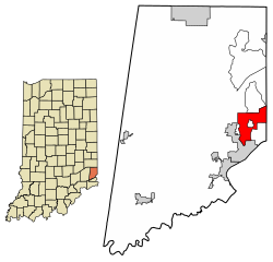
Dearborn County Indiana Incorporated and Unincorporated areas Greendale Highlighted 1829448.svg
Location of Greendale in Dearborn County, Indiana.
Coordinates: 39°08′20″N84°51′40″W / 39.13889°N 84.86111°W / 39.13889; -84.86111
Country United States
State Indiana
County Dearborn
Government
   Mayor Alan Weiss (I) [1]
Area
[2]
  Total5.73 sq mi (14.84 km2)
  Land5.66 sq mi (14.67 km2)
  Water0.07 sq mi (0.18 km2)
Elevation
[3]
650 ft (200 m)
Population
 (2020)
  Total4,602
  Density812.64/sq mi (313.78/km2)
Time zone UTC-5 (EST)
  Summer (DST) UTC-4 (EDT)
ZIP code
47025
Area code 812
FIPS code 18-29448 [4]
GNIS feature ID2394982 [3]
Website Greendale, Indiana

Greendale is a city in Dearborn County, Indiana, United States. The population was 4,520 at the 2010 census.

Contents

History

Greendale was laid out in 1852, but the plat was not recorded until 1883. [5] [6] Greendale likely took its name from Greendale Cemetery. [7]

Geography

According to the 2010 census, Greendale has a total area of 5.785 square miles (14.98 km2), of which 5.71 square miles (14.79 km2) (or 98.7%) is land and 0.075 square miles (0.19 km2) (or 1.3%) is water. [8]

Demographics

Historical population
CensusPop.Note
1880 286
1890 43552.1%
1900 4738.7%
1910 69747.4%
1920 7639.5%
1930 1,05037.6%
1940 1,54847.4%
1950 2,01830.4%
1960 2,86141.8%
1970 3,78332.2%
1980 3,7950.3%
1990 3,8812.3%
2000 4,29610.7%
2010 4,5205.2%
2020 4,6021.8%
U.S. Decennial Census [9]

2010 census

As of the census [10] of 2010, there were 4,520 people, 1,809 households, and 1,241 families living in the city. The population density was 791.6 inhabitants per square mile (305.6/km2). There were 1,942 housing units at an average density of 340.1 per square mile (131.3/km2). The racial makeup of the city was 95.6% White, 1.0% African American, 0.2% Native American, 0.8% Asian, 0.6% from other races, and 1.8% from two or more races. Hispanic or Latino of any race were 1.6% of the population.

There were 1,809 households, of which 33.1% had children under the age of 18 living with them, 49.9% were married couples living together, 12.8% had a female householder with no husband present, 5.9% had a male householder with no wife present, and 31.4% were non-families. 27.1% of all households were made up of individuals, and 12.6% had someone living alone who was 65 years of age or older. The average household size was 2.50 and the average family size was 3.02.

The median age in the city was 40.1 years. 24.4% of residents were under the age of 18; 6.9% were between the ages of 18 and 24; 25% were from 25 to 44; 28.4% were from 45 to 64; and 15.3% were 65 years of age or older. The gender makeup of the city was 47.8% male and 52.2% female.

2000 census

As of the census [4] of 2000, there were 4,296 people, 1,781 households, and 1,212 families living in the city. The population density was 710.5 inhabitants per square mile (274.3/km2). There were 1,852 housing units at an average density of 306.3 per square mile (118.3/km2). The racial makeup of the city was 97.91% White, 0.58% African American, 0.07% Native American, 0.49% Asian, 0.02% from other races, and 0.93% from two or more races. Hispanic or Latino of any race were 0.33% of the population.

There were 1,781 households, out of which 29.4% had children under the age of 18 living with them, 53.2% were married couples living together, 10.9% had a female householder with no husband present, and 31.9% were non-families. 27.8% of all households were made up of individuals, and 14.2% had someone living alone who was 65 years of age or older. The average household size was 2.41 and the average family size was 2.95.

In the city, the population was spread out, with 23.2% under the age of 18, 7.4% from 18 to 24, 28.3% from 25 to 44, 25.0% from 45 to 64, and 16.1% who were 65 years of age or older. The median age was 40 years. For every 100 females, there were 89.4 males. For every 100 females age 18 and over, there were 86.7 males.

The median income for a household in the city was $45,926, and the median income for a family was $55,713. Males had a median income of $40,192 versus $23,176 for females. The per capita income for the city was $23,452. About 3.0% of families and 5.1% of the population were below the poverty line, including 6.6% of those under age 18 and 8.9% of those age 65 or over.
Related Research Articles

<span class="mw-page-title-main">Phillips County, Colorado</span> County in Colorado, United States

Phillips County is a county located in the U.S. state of Colorado. As of the 2020 census, the population was 4,530. The county seat is Holyoke. The county was named in honor of R.O. Phillips, a secretary of the Lincoln Land Company, who organized several towns in Colorado.

<span class="mw-page-title-main">Aurora, Indiana</span> City in Indiana, United States

Aurora is a city in Center Township, Dearborn County, Indiana, United States. The population was 3,750 at the 2010 census.

<span class="mw-page-title-main">Bright, Indiana</span> Census-designated place in Indiana, United States

Bright is an unincorporated community and census-designated place (CDP) in Dearborn County, Indiana, United States. The population was 5,814 at the 2020 census.

<span class="mw-page-title-main">Dillsboro, Indiana</span> Town in Indiana, United States

Dillsboro is a town in Clay Township, Dearborn County, Indiana, United States. As of 2020, the population is 1,360.

<span class="mw-page-title-main">Hidden Valley, Indiana</span> Census-designated place in Indiana, United States

Hidden Valley is a private residential community in Dearborn County, Indiana, United States. For statistical purposes it is a census-designated place (CDP), with a population of 5,387 at the 2010 census, up from 4,417 at the 2000 census.

<span class="mw-page-title-main">Lawrenceburg, Indiana</span> City in Indiana, United States

Lawrenceburg is a city and the county seat of Dearborn County, Indiana, United States. The population was 5,129 at the 2020 census. It is the largest city in Dearborn County. Lawrenceburg is in southeast Indiana, on the Ohio River west of Cincinnati.

<span class="mw-page-title-main">Moores Hill, Indiana</span> Town in Indiana, United States

Moores Hill is a town in Sparta Township, Dearborn County, Indiana, United States. The population was 597 at the 2010 census.

<span class="mw-page-title-main">St. Leon, Indiana</span> Town in Indiana, United States

St. Leon or Saint Leon is a town in Kelso Township, Dearborn County, Indiana, United States. The population was 678 at the 2010 census.

<span class="mw-page-title-main">West Harrison, Indiana</span> Town in Indiana, United States

West Harrison is a town in Harrison Township, Dearborn County, Indiana, United States. The population was 289 at the 2010 census.

<span class="mw-page-title-main">Stilesville, Indiana</span> Town in Indiana, United States

Stilesville is a town in Franklin Township, Hendricks County, Indiana, United States. The population was 316 at the 2010 Census.

<span class="mw-page-title-main">Pottawattamie Park, Indiana</span> Town in Indiana, United States

Pottawattamie Park is a town in Michigan Township, LaPorte County, Indiana, United States. The population was 235 at the 2010 census. It is included in the Michigan City, Indiana-La Porte, Indiana Metropolitan Statistical Area.

<span class="mw-page-title-main">Rising Sun, Indiana</span> City in Indiana, United States

Rising Sun is a city in Randolph Township and the county seat of Ohio County, Indiana, United States, along the Ohio River. It is also the only incorporated community in the county. The population of Rising Sun was 2,304 at the 2010 census.

<span class="mw-page-title-main">Parker City, Indiana</span> Town in Indiana, United States

Parker City is a town in Monroe Township, Randolph County, in the U.S. state of Indiana. The population was 1,419 at the 2010 census.

<span class="mw-page-title-main">Camanche, Iowa</span> City in Iowa, United States

Camanche is a city in Clinton County, Iowa, United States, on the Mississippi River. The population was 4,570 at the time of the 2020 census.

<span class="mw-page-title-main">Fairway, Kansas</span> City in Kansas, United States

Fairway is a city in Johnson County, Kansas, United States. It is included in the Kansas City metropolitan area census designation and the Shawnee Mission postal services designation. As of the 2020 United States census, the city population was 4,170.

<span class="mw-page-title-main">Reading Township, Michigan</span> Civil township in Michigan, United States

Reading Township is a civil township of Hillsdale County in the U.S. state of Michigan. The population was 1,910 at the 2020 census.

<span class="mw-page-title-main">Greendale Township, Michigan</span> Civil township in Michigan, United States

Greendale Township is a civil township of Midland County in the U.S. state of Michigan. As of the 2020 census, the township population was 1,731.

<span class="mw-page-title-main">Greendale, Missouri</span> City in Missouri, United States

Greendale is a city in St. Louis County, Missouri, United States. The population was 651 at the 2010 census.

<span class="mw-page-title-main">Aurora, Nebraska</span> City in Nebraska, United States

Aurora is a city in Hamilton County, Nebraska, United States. The population was 4,479 at the 2010 census. It is the county seat of Hamilton County.

<span class="mw-page-title-main">Dearborn, Missouri</span> City in Missouri, United States

Dearborn is a city in Buchanan and Platte counties in the U.S. state of Missouri and is part of the Kansas City metropolitan area. The population was 496 at the 2010 census.

References

  1. Awad, Joe (November 3, 2015). "Independent Weiss Wins 3-way Greendale mayoral contest". Dearborn County Register. Archived from the original on April 9, 2016. Retrieved March 30, 2016.
  2. "2020 U.S. Gazetteer Files". United States Census Bureau. Retrieved March 16, 2022.
  3. 1 2 U.S. Geological Survey Geographic Names Information System: Greendale, Indiana
  4. 1 2 "U.S. Census website". United States Census Bureau . Retrieved January 31, 2008.
  5. Shaw, Archibald (1915). History of Dearborn County, Indiana: Her People, Industries and Institutions. Unigraphic. pp.  192.
  6. History of Dearborn and Ohio Counties, Indiana. F. E. Weakley. 1885. pp.  424.
  7. Baker, Ronald L. (October 1995). From Needmore to Prosperity: Hoosier Place Names in Folklore and History . Indiana University Press. p.  151. ISBN   978-0-253-32866-3. ...Apparently the town was named for the local Greendale Cemetery...
  8. "G001 - Geographic Identifiers - 2010 Census Summary File 1". United States Census Bureau. Archived from the original on February 13, 2020. Retrieved July 28, 2015.
  9. "Census of Population and Housing". Census.gov. Retrieved June 4, 2015.
  10. "U.S. Census website". United States Census Bureau . Retrieved December 11, 2012.