Related Research Articles
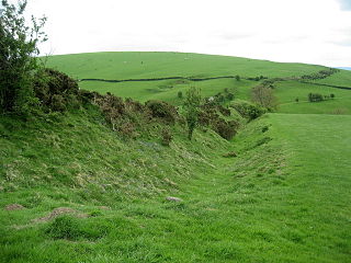
Offa's Dyke is a large linear earthwork that roughly follows the border between England and Wales. The structure is named after Offa, the Anglo-Saxon king of Mercia from AD 757 until 796, who is traditionally believed to have ordered its construction. Although its precise original purpose is debated, it delineated the border between Anglian Mercia and the Welsh kingdom of Powys.

Offa's Dyke Path is a long-distance footpath broadly following the Wales–England border. Officially opened on 10 July 1971, by Lord Hunt, it is one of Britain's National Trails and draws walkers from throughout the world. About 60 miles (97 km) of the 177-mile (285 km) route either follows, or keeps close company with, the remnants of Offa's Dyke, an earthwork, most of which was probably constructed in the late 8th century on the orders of King Offa of Mercia.

Powys is a county and preserved county in Wales. It is named after the Kingdom of Powys which was a Welsh successor state, petty kingdom and principality that emerged during the Middle Ages following the end of Roman rule in Britain.
The Welsh Marches is an imprecisely defined area along the border between England and Wales in the United Kingdom. The precise meaning of the term has varied at different periods.

Montgomeryshire, also known as Maldwyn, is one of thirteen historic counties and a former administrative county of Wales. It is named after its county town, Montgomery, which in turn is named after one of William the Conqueror's main counsellors, Roger de Montgomerie, who was the 1st Earl of Shrewsbury.
Knighton is a border market town and community in Powys, Wales and Shropshire, England, on the River Teme. It lies on the England–Wales border. The Teme is not navigable in its higher reaches and the border does not follow its course exactly. Originally an Anglo-Saxon settlement, Knighton is located on Offa's Dyke, the ancient earthwork that divided the two countries. It later became a Norman defensive border town.

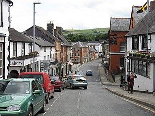
Montgomery is a town and community in the Welsh Marches, administratively in the Welsh county of Powys. It is the traditional county town of the historic county of Montgomeryshire to which it gives its name. The town centre lies about 1 mile (1.6 km) west of the English border. Montgomery Castle was started in 1223 and its parish church in 1227. Other locations in the town include The Old Bell Museum, the Offa's Dyke Path, the Robber's Grave and the town wall. The large Iron Age hill fort of Ffridd Faldwyn is sited northwest of the town and west of the Castle.

The Kingdom of Powys was a Welsh successor state, petty kingdom and principality that emerged during the Middle Ages following the end of Roman rule in Britain. It very roughly covered the northern two-thirds of the modern county of Powys and part of today's English West Midlands. More precisely, and based on the Romano-British tribal lands of the Ordovices in the west and the Cornovii in the east, its boundaries originally extended from the Cambrian Mountains in the west to include the modern West Midlands region of England in the east. The fertile river valleys of the Severn and Tern are found here, and this region is referred to in later Welsh literature as "the Paradise of Powys".
The Maelor is an area of north-east Wales along the border with England. It is now entirely part of Wrexham County Borough.
Clun Forest is a remote, rural area of open pastures, moorland and mixed deciduous/coniferous woodland in the southwest part of the English county of Shropshire and also just over the border into Powys, Wales.
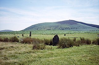
Corndon Hill is a hill in Powys, Mid Wales, whose isolated summit rises to 1,683 ft above sea level.

Churchstoke or Church Stoke is a village, community and electoral ward in Montgomeryshire, Powys, Wales. Located in the southeast of the Vale of Montgomery, it is overlooked by Todleth Hill, Roundton Hill and Corndon Hill. The rivers Caebitra and Camlad have their confluence just outside the village. The nearest town is Montgomery. In the 2011 census the village had a population of 708.
East Wales refers to either a ITL 3 statistical region of Wales or generally a region encompassing the easternmost parts of the country.

Wat's Dyke is a 40-mile (64 km) linear earthwork running through the northern Welsh Marches from Basingwerk Abbey on the River Dee estuary, passing east of Oswestry and on to Maesbury in Shropshire, England. It runs generally parallel to Offa's Dyke, sometimes within a few yards but never more than three miles (5 km) away. It now appears insignificant, sometimes a raised hedgerow and in other places is now no more than a cropmark, the ditch long since filled in and the bank ploughed away, but originally it was a considerable construction, considered to be strategically more sophisticated than Offa's Dyke. The date of construction is disputed, ranging from sub-Roman to the early ninth century.

Hen Domen Welsh, meaning "old mound", is the site of a medieval timber motte-and-bailey castle in Powys, Wales. It is the site of the original Montgomery Castle, and was built by Roger de Montgomery in 1070. From 1105 the castle was the home of the de Boulers (Bowdler) family, and it is from Baldwin de Boulers that Montgomery gets its Welsh name, Trefaldwyn "The Town of Baldwin". When the castle was rebuilt in stone (1223–1234), it was decided to rebuild it on a rocky promontory a mile to the south-east – the location of the current town of Montgomery, Powys. The Hen Domen site has been extensively excavated.

Buttington is a village in Powys, Wales, less than 3 km from Welshpool and about 300 m from the River Severn, in the community of Trewern. The Montgomery Canal passes through the village. The village stands on a slight rise above the river's floodplain, by the ancient ford called Rhyd-y-groes, where Offa's Dyke meets the Severn. The ford retained strategic value: reportedly in 1039 a battle took place here between Welsh and English forces.

Bacheldre is a small settlement in Powys, Wales. It is near the A489 road and is 5 kilometres (3 mi) southeast of the town of Montgomery.

The England–Wales border, sometimes referred to as the Wales–England border or the Anglo–Welsh border, runs for 160 miles (260 km) from the Dee estuary, in the north, to the Severn estuary in the south, separating England and Wales.

Hyssington is a parish in the South-Eastern corner of the historic county of Montgomeryshire in Wales and borders the county of Shropshire in England. It is now within the area of the Church Stoke community council in Powys. It is dominated by Corndon Hill. The church which is in the Diocese of Hereford lies just the north of a small village and is sited just to the west of a medieval Motte-and-bailey castle. This area was also the source of late Neolithic and Early Bronze Age battle-axes and axe-hammers, made from picrite that were widely traded around 2000 BC.
St Nicholas's Church, formerly called St Mary's Church until 1881, is a Church of England parish church in Church Stoke, Powys, Wales. The church's current building is largely the result of 19th-century reconstruction, but it retains its 13th-century tower with a later timber belfry. From the period prior to the 19th century, only a font, a stoup and a chest have survived up to three phases of restoration and reconstruction. The main body of the church with its large high pitched roof dates to the second half of the 19th century. It is a Grade II listed building.
References
- ↑ "Historic Landscape Characterisation: Vale of Montgomery". Clwyd-Powys Archaeological Trust. Retrieved 28 December 2020.
Coordinates: 52°33′22″N3°06′21″W / 52.5562°N 3.1059°W
| | This Powys location article is a stub. You can help Wikipedia by expanding it. |
| | This Shropshire location article is a stub. You can help Wikipedia by expanding it. |