
Oxfordshire is a ceremonial county in South East England. The county is bordered by Northamptonshire and Warwickshire to the north, Buckinghamshire to the east, Berkshire to the south, and Wiltshire and Gloucestershire to the west. The city of Oxford is the largest settlement and county town.

East Stour is a village and civil parish in the ceremonial county of Dorset in southern England. It lies within the Dorset administrative district, about two miles south of the town of Gillingham. The village is 1⁄2 mile from the east bank of the River Stour in the Blackmore Vale and two miles west of the broadly conical local landmark Duncliffe Hill. Above the west bank of the river, about one mile away, is the village of West Stour. The A30 London to Penzance road passes through the village. In the 2011 census the civil parish had a population of 573.
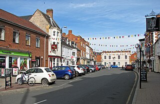
Shipston-on-Stour is a town and civil parish in the Stratford-on-Avon District in southern Warwickshire, England. It is located on the banks of the River Stour, 9 miles (15 km) south-southeast of Stratford-upon-Avon, 10 miles north-northwest of Chipping Norton, 14 miles (22 km) south of Warwick and 14.5 miles west of Banbury. In the 2021 census, Shipston-on-Stour had a population of 5,849.
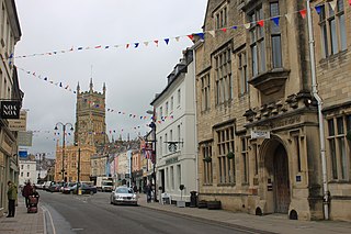
Cotswold is a local government district in Gloucestershire, England. It is named after the wider Cotswolds region and range of hills. The council is based in the district's largest town of Cirencester. The district also includes the towns of Chipping Campden, Fairford, Lechlade, Moreton-in-Marsh, Northleach, Stow-on-the-Wold and Tetbury, along with numerous villages and surrounding rural areas.

Warwickshire is a ceremonial county in the West Midlands of England. It is bordered by Staffordshire and Leicestershire to the north, Northamptonshire to the east, Oxfordshire and Gloucestershire to the south, and Worcestershire and the West Midlands county to the west. The largest settlement is Nuneaton and the county town is Warwick.
The Vale of White Horse is a local government district of Oxfordshire in England. It was historically part of Berkshire. The area is commonly referred to as the 'Vale of the White Horse'. It is crossed by the Ridgeway National Trail in its far south, across the North Wessex Downs AONB at the junction of four counties. The northern boundary is defined by the River Thames. The name refers to Uffington White Horse, a prehistoric hill figure.

Stratford-on-Avon is a local government district in Warwickshire, England. The district is named after its largest town of Stratford-upon-Avon, but with a change of preposition; the town uses "upon" and the district uses "on". The council is based in Stratford-upon-Avon and the district, which is predominantly rural, also includes the towns of Alcester, Henley-in-Arden, Shipston-on-Stour and Southam, and the large villages of Bidford-on-Avon, Studley and Wellesbourne, plus numerous other smaller villages and hamlets and surrounding rural areas. The district covers the more sparsely populated southern part of Warwickshire, and contains nearly half the county's area. The district includes part of the Cotswolds, a designated Area of Outstanding Natural Beauty.

Kineton is a village and civil parish on the River Dene in south-east Warwickshire, England. The village is part of Stratford-on-Avon district, and in the 2001 census it had a population of 2,278, increasing to 2,337 at the 2011 Census.

Stratford-on-Avon is a constituency represented in the House of Commons of the UK Parliament since 2024 by Manuela Perteghella of the Liberal Democrats. The constituency is in Warwickshire; as its name suggests, it is centred on the town of Stratford-upon-Avon, birthplace of William Shakespeare, but also takes in the surrounding areas, including the towns of Alcester and Henley-in-Arden.

Kenilworth and Southam is a constituency in Warwickshire, England represented in the House of Commons of the UK Parliament since 2010 by Jeremy Wright, a Conservative who served as Culture Secretary until 24 July 2019, having previously served as Attorney General for England and Wales from 2014 to 2018.

Ilmington is a village and civil parish about 3.5 miles (5.6 km) north-west of Shipston-on-Stour and 8 miles (13 km) south of Stratford-upon-Avon in the Cotswolds in Warwickshire, England. The population of the civil parish taken at the 2011 census was 712. Ilmington is the highest village in Warwickshire and is at the foot of the Ilmington Downs, which is the highest point in Warwickshire. Residents are called "Ilmingtonians".

Brailes is a civil parish about 3 miles (5 km) east of Shipston-on-Stour in Warwickshire, England. It includes the two villages of Lower and Upper Brailes which are located in the north Cotswolds, but it is often referred to as one village as the two villages adjoin each other. The parish includes the village of Winderton about 1.5 miles (2.4 km) northeast of Brailes, and the deserted medieval village of Chelmscote about 3.5 miles (5.6 km) north of Brailes. The parish is bounded to the east by Ditchedge Lane and Beggars' Lane, which are a historic ridgeway that also forms part of the county boundary with Oxfordshire. The northeastern boundary is a minor road, part of which follows the course of a Roman road.

Great Wolford is a village and civil parish in the Stratford-on-Avon district of Warwickshire, England. With the neighbouring parish of Little Wolford it is part of 'The Wolfords'.

Tysoe is a civil parish in the Stratford-on-Avon District of Warwickshire, England. The parish is on the boundary with Oxfordshire, about 7+1⁄2 miles (12 km) northwest of Banbury. The parish includes the contiguous villages of Middle and Upper Tysoe and the separate hamlet of Lower Tysoe. The 2011 census recorded the parish population as 1,143.

Whatcote is a village and civil parish in Warwickshire, England, about 4 miles (6.4 km) northeast of Shipston on Stour in the Vale of the Red Horse. The population at the 2011 census was 143.

Campden was, from 1894 to 1935, a rural district in the administrative county of Gloucestershire, England. The district lay on the north-eastern boundary of Gloucestershire, and consisted of three separate areas nearly surrounded by the counties of Warwickshire and Worcestershire. The county and district boundaries were simplified in 1931 and the district was abolished in 1935.

Pillerton Hersey is a village and civil parish about 5.5 miles (9 km) north of Shipston-on-Stour in Warwickshire, England. The village is on a stream that flows northwest to join the River Dene. The 2011 Census recorded the parish's population as 170.
The Red Horse of Tysoe was a hill figure in the parish of Tysoe, South Warwickshire, England, cut into the red clay below the escarpment of Edgehill. It gave its name to the surrounding area, which is still known as the Vale of Red Horse or Red Horse Vale. The figure was first recorded in 1607, and in its earliest form was nearly 100 yards long. Various dates have been suggested for its creation, ranging from the Anglo-Saxon period to the 15th century.
