The Collegiate Church of the Holy and Undivided Trinity, Stratford-upon-Avon, is a Grade I listed parish church of the Church of England in Stratford-upon-Avon, Warwickshire, England. It is often known simply as Holy Trinity Church or as Shakespeare's Church, due to its fame as the place of baptism, marriage and burial of William Shakespeare. More than 200,000 tourists visit the church each year.

Great Alne is a small village in Warwickshire, England, 7 miles (11 km) north-west of Stratford-upon-Avon, 3 miles (4.8 km) north-east of Alcester and 15 miles (24 km) from Warwick, on the road to Wootton Wawen. It takes its name from the River Alne and was first chronicled in the charter of King Ethelbald (723–737). In 1969 Warwickshire County Council designated part of Great Alne as a Conservation Area, including most of the village east of the Memorial Hall and twelve listed buildings of local architectural and historical value. At the 2001 Census the population was 587.

Aston Cantlow is a village in Warwickshire, England, on the River Alne 5 miles (8.0 km) north-west of Stratford-upon-Avon and 2 miles (3.2 km) north-west of Wilmcote, close to Little Alne, Shelfield, and Newnham. It was the home of Mary Arden, William Shakespeare's mother. At the 2001 census, it had a population of 1,674, being measured again as 437 at the 2011 Census.

Bearley is a village and civil parish in the Stratford-on-Avon district of Warwickshire, England. The village is about five miles (8 km) north of Stratford-upon-Avon, bounded on the north by Wootton Wawen, on the east by Snitterfield, and on the south and west by Aston Cantlow. The western boundary is formed by a stream running out of Edstone Lake; it would seem that the land, now part of Edstone in Wootton Wawen, between the stream where it flows west from the lake and the road running east from Bearley Cross, was originally included in Bearley. The land within the parish rises gradually from a height of 216 ft (66 m), in the north-west at Bearley Cross, to about 370 ft (110 m), at the south-east corner of the parish, and is open except along its eastern boundary, where part of the extensive wood known as Snitterfield Bushes is included in Bearley.

Temple Grafton is a village and civil parish in the Stratford-on-Avon district of Warwickshire, England, situated about 4 miles (6.4 km) east of Alcester and 14 miles (23 km) west of the county town of Warwick. The place name is misleading, the Knights Templar never having any association with the place but owing to a naming error made in the time of Henry VIII the mistake has been perpetuated. During the reign of Richard I the estate in fact belonged to the Knights Hospitaller. During the reign of Edward III in 1347 the village was recorded as Grafton Superior while neighbouring Ardens Grafton was named Inferior.

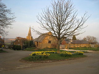
Snitterfield is a village and civil parish in the Stratford on Avon district of Warwickshire, England, less than 1 mile (1.6 km) to the north of the A46 road, 4.5 miles (7.2 km) from Stratford upon Avon, 6.5 miles (10.5 km) from Warwick and 17 miles (27 km) from Coventry. The population of the civil parish at the 2011 census was 1,226.

Wixford is a hamlet and civil parish in the Stratford-on-Avon District of Warwickshire, England, situated 1.5 miles (2.4 km) south of Alcester. The population at the 2011 census was 155. The area is largely agricultural with no large employers in the area, most residents commuting to larger towns nearby.

Stratford-sub-Castle in Wiltshire, England, was anciently a separate village and civil parish, but is now in Salisbury. At approximately 170 ft above sea level, it is dominated to the east by the remains of an Iron Age hillfort, within the boundaries of which a Norman castle was built. This now-ruined castle led to the village taking the name Stratford-under-Castle, later changing to Stratford sub Castle. Stratford lies south-west of the abandoned medieval settlement of Old Sarum which was also built within the area of the hillfort.

Great Wolford is a village and civil parish in the Stratford-on-Avon district of Warwickshire, England. With the neighbouring parish of Little Wolford it is part of 'The Wolfords'.
Greatworth is a village in the civil parish of Greatworth and Halse about 4 miles (6.4 km) north-west of Brackley, West Northamptonshire, England. The parish also includes the hamlet of Halse. In 2011, the settlement had a population of 708. The 2011 Census recorded the parish population as 890.

Whatcote is a village and civil parish in Warwickshire, England, about 4 miles (6.4 km) northeast of Shipston on Stour in the Vale of the Red Horse. The population at the 2011 census was 143.
St Lawrence's Church at Stratford-sub-Castle is a 13th-century Grade I listed Church of England parish church, to the north of Salisbury, Wiltshire, England. It stands close to the abandoned settlement of Old Sarum and the River Avon, and is about 2 miles (3.2 km) north of Salisbury Cathedral.
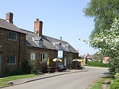
Morton Bagot is a small village in the Stratford-on-Avon District of Warwickshire, England. It lies about 1.5 miles (2 km) east of the Birmingham-Alcester road, the modern A435 and Roman road Ryknild Street, 6.5 miles (10 km) north of Alcester, 9.5 miles (15 km) from Stratford-upon-Avon and 12 miles from Warwick, across the valley of a small brook, flowing south-east to join the River Arrow.

Alkerton is a village and former civil parish, now in the parish of Shenington with Alkerton, in the Cherwell district, in the county of Oxfordshire, England. It is on the county boundary with Warwickshire, about 5 miles (8 km) west of Banbury. In 1961 the parish had a population of 82. On 1 April 1970 the parish was abolished and merged with Shenington to form "Shenington with Alkerton".

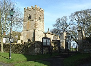
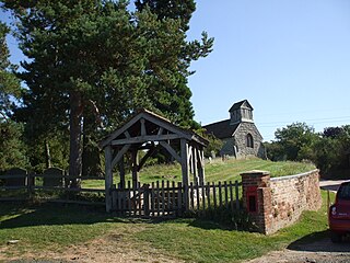
St John the Baptist's Church is a redundant Anglican church in the village of Avon Dassett, Warwickshire, England. It is recorded in the National Heritage List for England as a designated Grade II* listed building, and is under the care of The Churches Conservation Trust.
Shotteswell is a village and civil parish in the Stratford-on-Avon district of Warwickshire. The population of the civil parish at the 2011 census was 221. The parish is bounded on three sides by Oxfordshire and is about 4 miles (6 km) north-west of Banbury.

St Helen's Church is an Anglican church in the village of Churchtown in Lancashire, England. Historically, it was the parish church of Garstang; today, as Garstang is split into more than one ecclesiastical parish, St Helen's parish is Garstang St Helen (Churchtown). It is in the Diocese of Blackburn. It has been designated a Grade I listed building by English Heritage. St Helen's is known as the "cathedral of The Fylde".

Preston Bagot is a village and civil parish in the Stratford district of Warwickshire, England, about 6 miles (9.7 km) west of the county town of Warwick. According to the 2001 census the population was 147, reducing to 127 at the 2011 census.

St Lawrence's Church is a Church of England church in North Hinksey, West Oxford, England. The church is dedicated to St Lawrence, a Christian martyr. It is a Grade II* Listed Building. The church has a chancel, nave and tower.

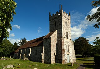
St Laurence's Church is a Church of England parish church in Upwey, Dorset, England. Much of the existing church dates to the late 15th century, with some earlier fabric and later additions of the 19th and 20th centuries. It is a Grade II* listed building.