Vallée de la Clarée

Last updated • 2 min readFrom Wikipedia, The Free Encyclopedia
Vallée de la Clarée
Vallee de la Claree -589.jpg
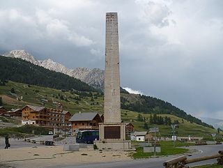
View of the Vallée de la Clarée
France location map-Regions and departements-2016.svg
Red pog.svg
Vallée de la Clarée
Floor elevation1,400–2,000 m (4,600–6,600 ft)
Length33 km (21 mi)south east
Geology
Type Glacial valley
Geography
Coordinates 44°58′00″N6°40′00″E / 44.9667°N 6.6667°E / 44.9667; 6.6667 Coordinates: 44°58′00″N6°40′00″E / 44.9667°N 6.6667°E / 44.9667; 6.6667

The Vallée de la Clarée is a scenic valley in the French Alps near to Montgenèvre, Briançon and the French-Italian border. The Clarée river runs through the valley.

Contents

The mountains on either side are part of the Massif des Cerces. To the west they are between 2800 and 2900m high, while on the east side they are between 2300 and 2400m high. Consequently, the snow is slow to melt and gives rise to the name of the central commune Névache meaning "snowed".

The valley lies at between 1400 and 2000m and contains meadows and larch forest. This alpine situation creates great biological diversity with several different habitats such as flooded soils and peat. These valleys contain 39% of known plant species in the French Alps, and 61% of those in the arrondissement of Briançon.

The Vallée de la Clarée and the adjoining Vallée Etroite cover 26,000 hectares and contain famous hiking trails (GR 57, Tour du Mont Thabor, Grande Traversée des Alpes). The valleys are exceptional area in that they have been preserved in their natural state. Agriculture, forestry and the rearing of livestock are still carried out traditionally.

Consequently, the valley is one of the most visited parts of the Hautes-Alpes department. Visitors have been estimated at 600,000 visits per year. As a result, and as a result of the campaign lead by Émilie Carles, the valleys have been given the status of protected areas since 1992. In the summer the valley is visited by cyclists and walkers and by riders who use the large stables in Les Alberts.

The river is used for water sports especially in spring as the snow melts. There are sections of white water, which are used by kayaks and white water rafts. There is a dramatic waterfall at Fontcouverte.

The valley in winter is covered in snow, which is enjoyed by many cross-country skiers. There are over 65 km of trails. It has one of the main circuits where the French cross-country team train. Although it is popular for cross-country ski-ing, the valley's protected status has prevented ski-lifts being installed.

The valley is famous for its numerous sun-dials.

Access

The valley is accessible by car via the Col de Montgenevre from Briançon in the summer or over the Col de l'Echelle from Bardonecchia (Italy). In July and August is the highest part of the valley is closed to motorised transport. Only a shuttle is allowed to take tourists to the Refuge de Laval at 2000m.

Places and monuments

Vallee de la Claree (taken from 3,500 m altitude) Vallee de la Claree (taken from 3,500 m altitude).jpg
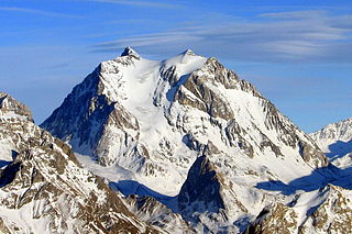
Vallée de la Clarée (taken from 3,500 m altitude)

Related Research Articles

Hautes-Alpes Department in Provence-Alpes-Côte dAzur, France

Hautes-Alpes is a department in the Provence-Alpes-Côte d'Azur region of Southeastern France. Located in and named after the Alps, it had a population of 141,107 in 2016. Its prefecture is Gap; its sole subprefecture is Briançon.

Briançon Subprefecture and commune in Provence-Alpes-Côte dAzur, France

Briançon (French: [bʁijɑ̃sɔ̃] is a commune in the Hautes-Alpes department in the Provence-Alpes-Côte d'Azur region in southeastern France. It is a sub-prefecture of the department.

Durance

The Durance is a major river in south-eastern France. A left tributary of the Rhône, it is 323.2 km (200.8 mi) long. Its drainage basin is 14,472 km2 (5,588 sq mi).

Col de Montgenèvre

The Col de Montgenèvre is a high mountain pass in the Cottian Alps, in France 2 kilometres away from Italy.

Arrondissement of Briançon Arrondissement in Provence-Alpes-Côte dAzur, France

The arrondissement of Briançon is an arrondissement of France in the Hautes-Alpes department in the Provence-Alpes-Côte d'Azur region. It has 36 communes. Its population is 35,266 (2016), and its area is 2,138.1 km2 (825.5 sq mi).

Maurienne Former Savoy province

Maurienne is one of the provinces of Savoy, corresponding to the arrondissement of Saint-Jean-de-Maurienne in France. It is also the original name of the capital of the province, now Saint-Jean-de-Maurienne.

Col de lIseran

Col de l'Iseran is a mountain pass in France, the highest paved pass in the Alps. A part of the Graian Alps, it is situated in the department of Savoie, near the border with Italy, and is crossed by the D902 roadway.

Col du Lautaret

Col du Lautaret is a high mountain pass in the department of Hautes-Alpes in France.

The Route nationale 6 is a trunk road (nationale) in France between Paris and the frontier with Italy in the Alps.

Abondance, Haute-Savoie Commune in Auvergne-Rhône-Alpes, France

Abondance is a commune in the Haute-Savoie department in the Auvergne-Rhône-Alpes region in south-eastern France.

Montgenèvre Commune in Provence-Alpes-Côte dAzur, France

Montgenèvre is a commune of the Hautes-Alpes department in southeastern France.

Risoul Commune in Provence-Alpes-Côte dAzur, France

Risoul is a commune in the Hautes-Alpes department in southeastern France. It is located in the French Alps between the towns of Briançon and Gap.

Névache Commune in Provence-Alpes-Côte dAzur, France

Névache is a commune in the Hautes-Alpes department in southeastern France.

Mieussy Commune in Auvergne-Rhône-Alpes, France

Mieussy is a commune in the Haute-Savoie department in the Auvergne-Rhône-Alpes region of France.

Clarée

The Clarée is a river in southeastern France, a right tributary to the Durance. It is 31.9 km (19.8 mi) long. Its drainage basin is 189 km2 (73 sq mi). Its source is in the Cottian Alps, near Mont Thabor and Valloire. It flows for all of its course in the Hautes-Alpes department. Its confluence with the Durance is near the hamlet of Les Alberts not far from the source of the Durance in the ski resort of Montgenevre.

Fortified Sector of the Dauphiné

The Fortified Sector of the Dauphiné was the French military organization that in 1940 controlled the section of the Alpine Line portion of the Maginot Line facing Italy in the vicinity of Briançon. By comparison with the integrated defenses of the main Maginot Line, or even of the Fortified Sector of the Maritime Alps to the south, the Dauphiné sector consisted of a series of distinct territories that covered two main invasion routes into France: the route from Turin over the Col de Montgenèvre to Briançon and Grenoble, and the route from Coni over the Col de Larche to Barcelonette and Gap. The sector was the scene of probing attacks by Italian forces during the Italian invasion of France in 1940, in which the French defenses successfully resisted Italian advances until the June 1940 armistice that granted Italy access to southeastern France.

Col de lÉchelle Alpine mountain pass in France

Col de l'Échelle is a mountain pass in the Alps in the department of Hautes-Alpes in France. It is the lower mountain pass between France and Italy and connects Vallée de la Clarée and Vallée Étroite. The highest point between both valleys is actually at 1779 meter, some kilometers north of the official Col de l'Échelle at the Mauvais Pas. Between both cols, a small dry valley exists.

Pointe Rochers Charniers Mountain in France

The Pointe Rochers Charniers is a mountain of the Cottian Alps at an elevation of 3,063 metres above sea level, located in France.

Grand Aréa Mountain in France

The Grand Aréa is a 2.869 metres high mountain of the Cottian Alps located in the French department of Hautes-Alpes.

LAiguille Rouge Mountain in France

L'Aguille Rouge is a 2,545 metres high mountain of the Cottian Alps, located on the Main chain of the Alps NW of the Col de l'Échelle.

References