
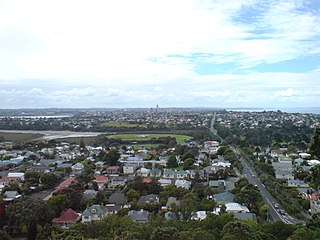
Devonport is a harbourside suburb of Auckland, New Zealand. It is located on the North Shore, at the southern end of a peninsula that runs southeast from near Lake Pupuke in Takapuna, forming the northern side of the Waitematā Harbour. East of Devonport lies North Head, the northern promontory guarding the mouth of the harbour.
The North Shore is part of the large urban area of Auckland, New Zealand, located to the north of the Waitematā Harbour. To the east, has the Hauraki Gulf, to the west, is West Auckland, to the south, has the Waitematā Harbour and Central Auckland, to the north has the Hibiscus Coast. From 1989 until 2010, North Shore City was an independent city within the Auckland Region, until it was incorporated into the Auckland Council.

Northcote is a suburb of Auckland in northern New Zealand. It is situated on the North Shore, on the northern shores of Waitematā Harbour, four km northwest of Auckland CBD. The suburb includes the peninsula of Northcote Point and the northern approaches to the Auckland Harbour Bridge. Northcote Central is to the north of Northcote.
East Coast Bays is a string of small suburbs that form the northernmost part of the North Shore, part of the contiguous Auckland metropolitan area in New Zealand. The suburbs line the north-east coast of the city along the shore of the Hauraki Gulf and Rangitoto Channel. They stretch from Long Bay in the north to Castor Bay in the south. They include, from north to south, Long Bay, Torbay, Waiake Bay, Browns Bay, Rothesay Bay, Murrays Bay, Mairangi Bay, Campbells Bay and Castor Bay.

Panmure is an east Auckland suburb, in the North Island of New Zealand. It is located 11 kilometres southeast of the Auckland CBD, close to the western banks of the Tāmaki River and the northern shore of the Panmure Basin. To the north lies the suburb of Tāmaki, and to the west is the cone of Maungarei / Mount Wellington.

Birkenhead is a suburb of Auckland, in northern New Zealand. It is located on the North Shore of the Waitemata Harbour, four kilometres northwest of the Auckland CBD.
North Harbour is a suburb on the North Shore of Auckland, New Zealand. It is located 12 kilometres north of the city centre, to the south of the suburb of Albany. The suburb has not been officially designated as a suburb by Auckland Council, the territorial authority. The place name holds no official status with the New Zealand Geographic Board, nor is it used by New Zealand Post. North Harbour is, however, a statistical area used in Statistics New Zealand datasets and North Harbour East and North Harbour West are area units. The general area that embodies what is referred to as the suburb of North Harbour is made up of parts of Albany, Rosedale, Schanpper Rock and Pinehill.

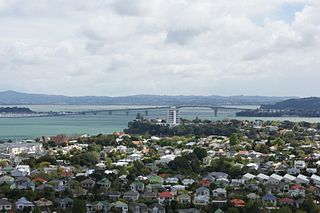
Takapuna is a suburb located on the North Shore of Auckland, New Zealand. The suburb is situated at the beginning of a south-east-facing peninsula forming the northern side of the Waitematā Harbour. While very small in terms of population, it was the seat of the North Shore City Council before amalgamation into Auckland Council in 2010 and contains substantial shopping and entertainment areas, acting as a CBD for the North Shore.
Vauxhall is a district in the London Borough of Lambeth. it may also refer to:

Forrest Hill is a suburb located on the North Shore of Auckland, New Zealand.
Hauraki is a suburb located on the southern North Shore of Auckland, the largest metropolitan city in New Zealand. It is under the local governance of the Auckland Council.

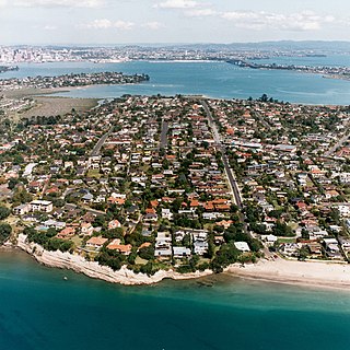
Bayswater is a suburb located on the North Shore of Auckland, New Zealand. It lies on a peninsula which juts into the Waitemata Harbour. Politically the suburb is part of the Devonport-Takapuna Local Board and the North Shore ward of Auckland Council.

Narrow Neck is a suburb located on the North Shore of Auckland, New Zealand. It is under the local governance of the Auckland Council.

Takapuna Grammar School is a state coeducational secondary school located in the suburb of Belmont on the North Shore of Auckland, New Zealand. Established in 1927, the school mainly serves the eponymous suburb of Takapuna and the entire Devonport Peninsula. A total of 2013 students from Years 9 to 13 attend the school as of February 2023.

Castor Bay is a bay and suburb of the North Shore, located in Auckland which is in the North Island of New Zealand. Located between Milford and Campbells Bay, it is part of the East Coast Bays. To the east lies the islands of Rangitoto and Motutapu, which are easily visible from land. The suburb is in the North Shore ward, one of the thirteen administrative divisions of Auckland Council.
Stanley Point is a small suburb located on the North Shore of Auckland, New Zealand. It is located near Devonport, another suburb. It is mostly residential. The Devonport Naval Base lies to the east of the bay on the south side of the Stanley Bay peninsula and is connected to storage facilities on the north side at Ngataringa Bay by a tunnel.

Belmont Intermediate School is a state coeducational intermediate school located in Belmont on the North Shore of Auckland, New Zealand. It was established in 1957.
Waverley is a suburb of the New Zealand city of Dunedin. It was named after Sir Walter Scott's novel Waverley, first novel in a series known as the Waverley Novels, among the most popular and widely read English-language novels of the 19th century. Waverley is located at the start of the Otago Peninsula, 2.4 kilometres (1.5 mi) southeast of the city centre, on a rise overlooking the Otago Harbour to the north.

Avondale is a suburb of Auckland, New Zealand. Located on the western Auckland isthmus, the suburb is often considered a part of West Auckland. It is located in the Whau local board area, one of the 21 administrative divisions for the Auckland Council.

Hillpark is a suburb in Auckland, New Zealand. It is bordered by suburbs of The Gardens on the east and Manurewa on the south. It was formerly part of Manukau City until the 2010 amalgamation of all of Auckland's councils, and is now under the governance of Auckland Council.

