Veringenstadt

Last updated • 6 min readFrom Wikipedia, The Free Encyclopedia
Veringenstadt
Wappen Veringenstadt.svg
Location of Veringenstadt within Sigmaringen district
Karte Veringenstadt.pngBingenMengenMengenScheerSchwenningenWald
Germany adm location map.svg
Red pog.svg
Veringenstadt
Baden-Wuerttemberg location map.svg
Red pog.svg
Veringenstadt
Coordinates: 48°10′42″N9°12′43″E / 48.17833°N 9.21194°E / 48.17833; 9.21194
Country Germany
State Baden-Württemberg
Admin. region Tübingen
District Sigmaringen
Government
   Mayor (202230) Maik Rautenberg [1]
Area
  Total31.24 km2 (12.06 sq mi)
Elevation
631 m (2,070 ft)
Population
 (2021-12-31) [2]
  Total2,143
  Density69/km2 (180/sq mi)
Time zone UTC+01:00 (CET)
  Summer (DST) UTC+02:00 (CEST)
Postal codes
72519
Dialling codes 07577
Vehicle registration SIG
Website www.veringenstadt.de

Veringenstadt (Swabian: Verenga) is a town in the district of Sigmaringen, in Baden-Württemberg, Germany. It is situated 10 km north of Sigmaringen.

Contents

Map Sigmaringen district Karte Veringenstadt.png
Map Sigmaringen district

Geographical location

Veringenstadt is situated in the valley of the Lauchert, a tributary of the Danube, between Gammertingen and Sigmaringen. The municipality area is 3125 hectares. [3]

Geology

The municipality Veringenstadt lies on the Lauchertgraben (Lauchert trench). East of Veringendorf a petrified sponge reef can be seen, which was created 140 million years ago. [4]

History

The area of the present municipality Veringenstadt was already settled in early historical times. The town itself is an ancient settlement which was already mentioned in a document around the year 786. It derives its name from a certain "Fara" or "Faro", was so well earlier "Faringa", about 1130 Veringin, later always Veringen. [5] The counts of Veringen were one of the wealthiest and most respected dynasties of the 11th and 12th century in southern Germany. [6] [7] Through targeted resettlement of population from the surrounding hamlets succeeded about 1250 the foundation of the city of Veringen (today Veringenstadt). After the Thirty Years' War (1618–1648) about 1650 farmers from Tirol were recruited for Veringenstadt and settled here. [8] From 1827 to 1925 Veringenstadt belonged to Oberamt Gammertingen. 1850 it became as part of the principality Hohenzollern-Sigmaringen prussian, and belonged to the province of Hohenzollern. Ore was mined in the 18th and 19th century. [4] Since 1927 the municipality belongs to the district of Sigmaringen. Since 1945, the city belonged to Württemberg-Hohenzollern, which opened in Baden-Württemberg in 1952. By the inclusion of expellees after 1945, the population of Veringenstadt has nearly doubled in the 1950s. [8] On February 1, 1972 Hermentingen was incorporated. The incorporation of Veringendorf was on January 1, 1975.

Municipality

The municipality combines the main locality Veringenstadt with the two villages Hermentingen and Veringendorf.

Coat of armsVillagesInhabitants
(15 January 2011)
Area
Wappen Veringenstadt.svg Veringenstadt (main locality)16111523 ha
Wappen Hermentingen.svg Hermentingen147488 ha
Wappen Veringendorf.svg Veringendorf5041052 ha
The arms of the Counts of Veringen (extinct 1415) Wappen Veringen.png
The arms of the Counts of Veringen (extinct 1415)

Crest

The emblem of Veringenstadt was officially approved 1947. Already 1320 a lion and a deer rod was used as coat of arms. The coat of arms shows a golden shield a red lion under a layer of a red deer rack. The lion comes from the Habsburg coat of arms, the deer bar is derived from the coat of arms of the Counts of Veringen.

Twinning

Veringenstadt maintains since 2012 a partnership with the city of Zwettl an der Rodl in Austria.

Points of interest

Museums

Buildings

Veringenstadt is dominated by a medieval core with half-timbered houses, the castle Veringen and religious buildings:

Veringenstadt St Nikolaus Veringenstadt St Nikolaus.jpg
Veringenstadt St Nikolaus
Veringenstadt - Castle and Peter chapell Veringenstadt - Burg und Peterskapelle - Th-Fink 02.JPG
Veringenstadt - Castle and Peter chapell

Electrical works (Brothers Haux 1902) in Veringendorf [10]

Teams

In Veringenstadt are more than 30 clubs. With currently 450 members, the TSV is the largest. (as of 15 January 2011). [3]

Economy and Infrastructure

Transportation

The municipalities Veringenstadt and Veringendorf were connected to the rail network by the Kleinengstingen-Sigmaringen railway. The Göpfelstein was tunneled at Veringenstadt. The 91-meter long tunnel was built by Italian workers. The first train passed through the tunnel Veringen at Christmas, 1907, the line was opened in 1908. [12] [13] The Federal Highway 32 led originally through the Veringenstadt center. Between 1975 and 1980, a road tunnel was built. Today daily drive around 5000 vehicles through the Schlossberg tunnel. The Public transport is guaranteed by the Verkehrsverbund Neckar-Alb-Donau (NALDO). The community is located in the comb 442.

Established businesses

The Schwörer Haus maintains in Veringenstadt a factory making fort massif houses, ceilings, precast concrete, chimneys.

Education

There are two schools in the nucleus. A primary school and since the school year 2010/2011 a branch of the Werkrealschule Gammertingen. [3] The school building of the Alb-Lauchert School in Veringenstadt, an elementary school, was built in 1953. In Veringenstadt there is a day care center with full-day care, in Veringendorf a kindergarten, which also accommodates children under three years. [3]

Freemen

1962 Stefan Fink Mayor of Veringenstadt 1962 Stefan Fink Burgermeister von Veringenstadt.jpg
1962 Stefan Fink Mayor of Veringenstadt

Sons and daughters of the city

Literature

Related Research Articles

<span class="mw-page-title-main">Sigmaringen</span> City in Germany

Sigmaringen is a town in southern Germany, in the state of Baden-Württemberg. Situated on the upper Danube, it is the capital of the Sigmaringen district.

Sigmaringen is a Landkreis (district) in the south of Baden-Württemberg, Germany. Neighboring districts are Reutlingen, Biberach, Ravensburg, Bodensee, Constance, Tuttlingen, and Zollernalbkreis.

<span class="mw-page-title-main">Province of Hohenzollern</span> Province of Prussia

The Province of Hohenzollern was a district of Prussia from 1850 to 1946. It was located in Swabia, the region of southern Germany that was the ancestral home of the House of Hohenzollern, to which the kings of Prussia belonged.

<span class="mw-page-title-main">Upper Swabia</span> Region in Germany

Upper Swabia is a region in Germany in the federal states of Baden-Württemberg and Bavaria. The name refers to the area between the Swabian Jura, Lake Constance and the Lech. Its counterpart is Lower Swabia (Niederschwaben), the region around Heilbronn.

<span class="mw-page-title-main">Bad Saulgau</span> Town in Baden-Württemberg, Germany

Bad Saulgau is a town in the district of Sigmaringen, in Baden-Württemberg, Germany. It is situated 23 km east of Sigmaringen, and 27 km north of Ravensburg between the Danube and Lake Constance.

<span class="mw-page-title-main">Neuenburg am Rhein</span> Town in Baden-Württemberg, Germany

Neuenburg am Rhein is a town in the district Breisgau-Hochschwarzwald in Baden-Württemberg in southern Germany.

<span class="mw-page-title-main">Gammertingen</span> Town in Baden-Württemberg, Germany

Gammertingen is a town in the district of Sigmaringen, in Baden-Württemberg, Germany. It is situated 18 km north of Sigmaringen.

<span class="mw-page-title-main">Hettingen</span> Town in Baden-Württemberg, Germany

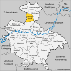
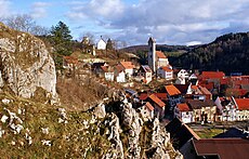
Hettingen is a town in the district of Sigmaringen, in Baden-Württemberg, Germany. It is situated 14 km north of Sigmaringen. Hettingen absorbed the formerly independent municipality Inneringen in 1975.

<span class="mw-page-title-main">Sigmaringen Castle</span>

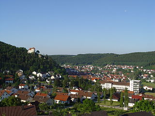
Sigmaringen Castle was the princely castle and seat of government for the Princes of Hohenzollern-Sigmaringen. Situated in the Swabian Alb region of Baden-Württemberg, Germany, this castle dominates the skyline of the town of Sigmaringen. The castle was rebuilt following a fire in 1893, and only the towers of the earlier medieval fortress remain. Schloss Sigmaringen was a family estate of the Swabian Hohenzollern family, a cadet branch of the Hohenzollern family, from which the German Emperors and kings of Prussia came. During the closing months of World War II, Schloss Sigmaringen was briefly the seat of the Vichy French Government after France was liberated by the Allies. The castle and museums may be visited throughout the year, but only on guided tours. It is still owned by the Hohenzollern-Sigmaringen family, although they no longer reside there.

<span class="mw-page-title-main">Langenenslingen</span> Municipality in Baden-Württemberg, Germany

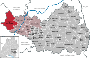
Langenenslingen is a municipality in the district of Biberach in Baden-Württemberg in Germany. It has a population close to 3,500.

<span class="mw-page-title-main">Bingen, Baden-Württemberg</span> Municipality in Baden-Württemberg, Germany

Bingen is a municipality in the district of Sigmaringen in Baden-Württemberg in Germany.

<span class="mw-page-title-main">Neufra</span> Municipality in Baden-Württemberg, Germany

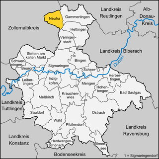
Neufra is a municipality in the district of Sigmaringen in Baden-Württemberg in Germany.

<span class="mw-page-title-main">Straßberg, Zollernalbkreis</span> German municipality

Straßberg is a municipality of the Zollernalb district of Baden-Württemberg, Germany.

<span class="mw-page-title-main">Winterlingen</span> German municipality

Winterlingen is a municipality in the Zollernalbkreis district of Baden-Württemberg, Germany.

<span class="mw-page-title-main">Princess Amalie Zephyrine of Salm-Kyrburg</span> Princess of Hohenzollern-Sigmaringen

Amalie Zephyrine of Salm-Kyrburg, was a German noblewoman by birth member of the House of Salm in the Salm-Kyrburg branch and through her marriage she was Princess of Hohenzollern-Sigmaringen.

<span class="mw-page-title-main">Lauchert</span> River in Germany

The Lauchert is a river in Baden-Württemberg, Germany, left tributary of the Danube. Its source is near Sonnenbühl, in the Swabian Alb. It is approx. 60 km long. It flows generally south through the small towns Gammertingen, Veringenstadt and Bingen. It flows into the Danube in Sigmaringendorf.

<span class="mw-page-title-main">Hundersingen</span> Ortsteil of Herbertingen in Baden-Württemberg, Germany

Hundersingen is a village within the municipality of Herbertingen and is part of the administrative district of Sigmaringen in the state of Baden-Württemberg, Germany. As of 2017, it had a population of 935. Current municipal administrator is Reinhold Eisele. Hundersingen has a nursery school and a primary school.

<span class="mw-page-title-main">Hohenzollerische Landesbahn</span> German railway company

The Hohenzollerische Landesbahn (HzL) is the largest non-federally owned railway company in the German state of Baden-Württemberg after the Albtal-Verkehrs-Gesellschaft and Südwestdeutsche Verkehrs-Aktiengesellschaft. It has operates passenger and freight traffic since 1900. Its field of activity now extends to large parts of southern Baden-Württemberg.

<span class="mw-page-title-main">Engstingen–Sigmaringen railway</span>

The Engstingen–Sigmaringen railway is a branch line in Baden-Württemberg, Germany. It is owned by the owned by the Hohenzollerische Landesbahn (HzL). It runs from Engstingen via Gammertingen to Sigmaringen and is single track and non-electrified throughout.

References

  1. Bürgermeisterwahl Veringenstadt 2022, Staatsanzeiger, accessed 1 February 2022.
  2. "Bevölkerung nach Nationalität und Geschlecht am 31. Dezember 2021" [Population by nationality and sex as of December 31, 2021](CSV) (in German). Statistisches Landesamt Baden-Württemberg. June 2022.
  3. 1 2 3 4 Ignaz Stösser (ist): Zahlen und Fakten. In: Ders.: Wir in Veringen. In: Schwäbische Zeitung. vom 15. Januar 2011.
  4. 1 2 Von Neandertalern und Bohnerzgruben. In: Wanderbar …die schönsten Routen. Erlebnis Kreis Sigmaringen. Landratsamt Sigmaringen, Druckerei Schönebeck, Meßkirch 2004, S. 5–7.
  5. Thomas Fink: Materialien zur Geschichte der Stadt Veringen. 2016.
  6. Sebastian Locher: Regesten zur Geschichte der Grafen zu Veringen. Sigmaringen 1872
  7. Interaktive Karte der Besitzungen
  8. 1 2 Ignaz Stösser (ist): Stadtfest Veringenstadt. Historienspiel dokumentiert das Kommen und Gehen. In: Schwäbische Zeitung. vom 24. Juni 2010.
  9. Ignaz Stösser (ist): Nostalgie und Moderne verbinden sich zu einem Ganzen. Vortrag im Mühlenmuseum. In: Schwäbische Zeitung. vom 11. Juli 2008.
  10. Clemens Kieser: Erster Strom aus der Steckdose. Das Elektrizitätswerk in Veringendorf (Veringenstadt, Lkrs. Sigmaringen). In: Denkmalpflege in Baden-Württemberg. 34. Jg. 2005, Heft 3, S. 169 f. (PDF) Archived 2014-07-14 at the Wayback Machine
  11. Landratsamt Sigmaringen. Besichtigung im Wasserwerk in Hermentingen. In: Blättle. Mitteilungsblatt der Gemeinde Krauchenwies mit den Ortsteilen Ablach, Bittelschieß, Ettisweiler, Göggingen und Hausen. Nummer 23. 51. Jahrgang. vom 11. Juni 2010.
  12. Ignaz Stösser: Gesperrt: Bund saniert Veringer Tunnel. B32-Verkehr rollt durch Veringer Ortsmitte – Inneringen und Bingen ebenfalls betroffen. In: Schwäbische Zeitung vom 18. Juni 2011.
  13. Kurt Roller (rol): Freizeitangebot. Veringen schwelgt im Dampfzugrausch. In: Schwäbische Zeitung. vom 21. Mai 2010.
  14. Lauchert-Zeitung. 21. Juni 1932.
  15. Lauchert-Zeitung 3. Januar 1933.
  16. "Simon Grynæus"  . Encyclopædia Britannica . Vol. XI (9th ed.). 1880. p. 226.
  17. Hohenzollerische Heimat. Hrsg.Hohenzollerischer Geschichtsverein e.V. Ausgabe 1971 - Der Bildhauer Egid Hochstein. 21 (1971) S. 90-92.