Verlautenheide

Last updated
Verlautenheide
of Aachen
Germany adm location map.svg
Red pog.svg
Verlautenheide
Coordinates: 50°47′47″N6°9′20″E / 50.79639°N 6.15556°E / 50.79639; 6.15556 Coordinates: 50°47′47″N6°9′20″E / 50.79639°N 6.15556°E / 50.79639; 6.15556
Country Germany
State North Rhine-Westphalia
District Haaren
City Aachen
Area
  Total 8.80 km2 (3.40 sq mi)
Elevation 214 m (702 ft)
Population
  Total 3,500
  Density 400/km2 (1,000/sq mi)
Time zone CET/CEST (UTC+1/+2)
Postal codes 52080
Dialling codes 02405
Center of Verlautenheide, with church Verlautenheide-kirche.jpg
Center of Verlautenheide, with church

Verlautenheide is a rural section of northeast Aachen, with a population of around 3500. The community lies within the administrative district of Haaren. Its highest point is the Haarberg (around 240 m).

Aachen Place in North Rhine-Westphalia, Germany

Aachen, also known as Bad Aachen, and in French and traditional English as Aix-la-Chapelle, is a spa and border city in North Rhine-Westphalia, Germany. Aachen developed from a Roman settlement and spa, subsequently becoming the preferred medieval Imperial residence of Charlemagne, and, from 936 to 1531, the place where 31 Holy Roman Emperors were crowned Kings of the Germans.

Haaren (Aachen) City of Aachen in North Rhine-Westphalia, Germany

The formerly independent town of Haaren lies four kilometers north of Aachen, into which it was incorporated in 1972.

Contents

The east end of the town is known as Quinx.

History

The village of Verlautenheide initially developed around the estate Heiderhof and was originally known as "Die Heyd". Much later, it became a Linear settlement (known in German as a Straßendorf). Verlautenheide was first mentioned (as Heide boven Haren) in 1445, in a lease and interest register for the Imperial Kornelimünster Abbey. The Kahlgracht Mill (Kahlgrachtmühle), which was built in the area of Verlautenheide in the 15th century, is an important testament to the town's existence then.

Linear settlement type of village

In geography, a linear settlement is a settlement or group of buildings that is formed in a long line. Many follow a transport route, such as a road, river, or canal though some form due to physical restrictions, such as coastlines, mountains, hills or valleys. Linear settlements may have no obvious centre, such as a road junction. Linear settlements have a long and narrow shape.

Kornelimünster Abbey abbey

Kornelimünster Abbey, also known as Abbey of the Abbot Saint Benedict of Aniane and Pope Cornelius, is a Benedictine monastery that has been integrated since 1972. The abbey is located in Aachen in North Rhine-Westphalia in Germany.

Together with Haaren, Verlautenheide belonged to Aachen until the end of the 19th century. At the time, Verlautenheide was also the location of one of the eight watchtowers surrounding and protecting Aachen, which is noted in the street name Türmchenweg (little tower way), which runs down the center of town. After France occupied Haaren and Verlautenheide in 1792 and 1794, administration of the town was maintained in Haaren under the French Mairie system, with the town formally becoming part of France as a result of the Treaty of Lunéville in 1801, before finally switching to the Kingdom of Prussia following the Treaty of Paris in 1814.

Treaty of Lunéville

The Treaty of Lunéville was signed in the Treaty House of Lunéville on 9 February 1801. The signatory parties were the French Republic and Holy Roman Emperor Francis II. The latter was negotiating both on his own behalf as ruler of the hereditary domains of the Habsburg Monarchy and on behalf of other rulers who controlled territories in the Holy Roman Empire. The signatories were Joseph Bonaparte and Count Ludwig von Cobenzl, the Austrian foreign minister.

Kingdom of Prussia Former German state (1701–1918)

The Kingdom of Prussia was a German kingdom that constituted the state of Prussia between 1701 and 1918. It was the driving force behind the unification of Germany in 1871 and was the leading state of the German Empire until its dissolution in 1918. Although it took its name from the region called Prussia, it was based in the Margraviate of Brandenburg, where its capital was Berlin.

The Treaty of Paris, signed on 30 May 1814, ended the war between France and the Sixth Coalition, part of the Napoleonic Wars, following an armistice signed on 23 April between Charles, Count of Artois, and the allies. The treaty set the borders for France under the House of Bourbon and restored territories to other nations. It is sometimes called the First Peace of Paris, as another one followed in 1815.

The area was intensely fought over in October 1944, and in Verlautenheide, US troops completed their surrounding of Aachen.

In the early 1960s, the first Aachen motorway "Wuerselen / Verlautenheide" (now Federal Highway 544) was built in Verlautenheide; around 1963, the motorway intersection with Aachen was completed.

Until the end of 1971, the community of Haaren/Verlautenheide was self-administered, but with the restructuring of Aachen's surrounding communities, the towns were incorporated into Aachen itself. [1]

Notable persons

Father Hugo Nießen worked in Verlautenheide in 1976. In October 1976 he became provost for the Protestant parish of St. Georg in the city of Wassenberg.

Societies

There is the sports club SV Eintracht 1912 Verlautenheide, which plays on astroturf, the Carnival Society Bröselspetze 1950 (die Karnevalsgesellschaft Bröselspetze e. V. 1950), as well as the St Georg Girl Scouts Troop of Verlautenheide (Verlautenheide der Pfadfinderinnenschaft St. Georg), which has operated since 1980. [2]

Related Research Articles

Hamm Place in North Rhine-Westphalia, Germany

Hamm is a city in North Rhine-Westphalia, Germany. It is located in the northeastern part of the Ruhr area. As of 2016 its population was 179,397. The city is situated between the A1 motorway and A2 motorway. Hamm railway station is an important hub for rail transport and renowned for its distinctive station building.

Aachen Cathedral Roman-Catholic cathedral in Aachen, Germany

Aachen Cathedral, traditionally called in English the Cathedral of Aix-la-Chapelle, is a Roman Catholic church in Aachen, western Germany, and the see of the Roman Catholic Diocese of Aachen.

Düren Place in North Rhine-Westphalia, Germany

Düren is a town in North Rhine-Westphalia, Germany, between Aachen and Cologne on the river Rur.

Demmin Place in Mecklenburg-Vorpommern, Germany

Demmin is a town in the Mecklenburgische Seenplatte district, Mecklenburg-Western Pomerania, Germany. It was the capital of the former district of Demmin.

Kulmbach Place in Bavaria, Germany

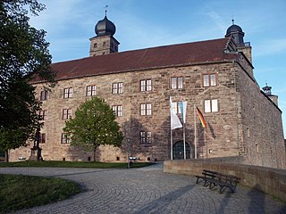
Kulmbach is the capital of the district of Kulmbach in Bavaria in Germany. The town is famous for Plassenburg Castle, which houses the largest tin soldier museum in the world, and for its famous sausages, or Bratwürste.

Thüngersheim Place in Bavaria, Germany

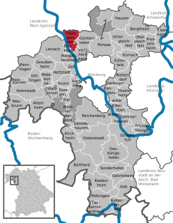
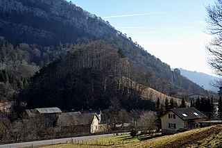
Thüngersheim is a community located in Germany. The community is situated on the River Main. It is a community in the district of Würzburg. The village is molded by the surrounding vineyards, more than 2 square kilometres (0.8 sq mi).

Feldkirch, Vorarlberg Place in Vorarlberg, Austria

Feldkirch is a medieval city in the western Austrian state of Vorarlberg on the border with Switzerland and Liechtenstein. It is the administrative center of the district Feldkirch. After Dornbirn, it is the second largest town in Vorarlberg in terms of population, with slightly more inhabitants than the state capital Bregenz. The westernmost point in Austria lies in Feldkirch on the river Rhine, at the northern tripoint border of Austria, Switzerland, and Liechtenstein.

Erkelenz Place in North Rhine-Westphalia, Germany

Erkelenz is a town in the Rhineland in western Germany that lies 15 kilometres southwest of Mönchengladbach on the northern edge of the Cologne Lowland, halfway between the Lower Rhine region and the Lower Meuse. It is a medium-sized town and the largest in the district of Heinsberg in North Rhine-Westphalia.

Schliersee Place in Bavaria, Germany

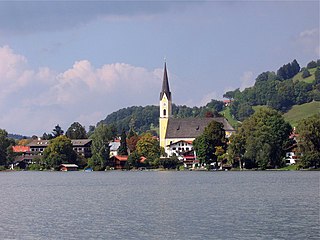
Schliersee is a small town (Markt) and a municipality in the district of Miesbach in Bavaria in Germany. It is named after the nearby Lake Schliersee. It comprises the districts Schliersee (town), Westenhofen, Neuhaus, Fischhausen, Josefsthal and Spitzingsee.

Korntal-Münchingen Place in Baden-Württemberg, Germany

Korntal-Münchingen is a town in the district of Ludwigsburg, Baden-Württemberg, Germany. It is situated at the northwestern border of Stuttgart and 8 km of its centre, and 10 km southwest of Ludwigsburg. Korntal was begun in the 19th Century when King Wilhelm of Württemberg permitted a group of Württemberg Pietists to erect a settlement based on the settlement congregations of the Herrnhuter Bruedergemeine or Moravian Church.

Jakob Dautzenberg was a German politician, member of the Communist Party of Germany, and resistance fighter against the Nazis. He was a member of the German Parliament during the Weimar Republic.

Laurensberg District of Aachen in North Rhine-Westphalia, Germany

Laurensberg is a community and district of Aachen, Germany.

Brand (Aachen) District of Aachen in North Rhine-Westphalia, Germany

Brand is a district of Aachen, Germany, with about 18,000 residents. The district lies in the southern part of Aachen and borders Kornelimünster/Walheim, Forst, Oberforstbach und Eilendorf, as well as the city of Stolberg.

Eilendorf (Aachen) District of Aachen in North Rhine-Westphalia, Germany

Eilendorf is a district of Aachen, Germany, that has around 15000 inhabitants. The communities of Eilendorf and Nirm share a border with the other Aachen districts of Brand, Aachen-Mitte, and Haaren, as well as the district of Atsch in Stolberg.

Kornelimünster/Walheim Stadtbezirk of Aachen in North Rhine-Westphalia, Germany

Kornelimünster/Walheim is the southern-most district of Aachen, Germany, and borders the Eifel area of North Rhine-Westphalia, as well as Belgium. It became part of Aachen in 1972, after all of the communities surrounding the city were reorganized administratively. The countryside is called Münsterländchen.

Péry-La Heutte Place in Bern, Switzerland

Péry-La Heutte is a municipality in the Jura bernois administrative district in the canton of Bern in Switzerland. It is located in the French-speaking Bernese Jura. On 1 January 2015 the former municipalities of Péry and La Heutte merged to form the new municipality of Péry-La Heutte.

Rheindahlen Stadtteil of Mönchengladbach in North Rhine-Westphalia, Germany

Rheindahlen is a town in the western and largest borough of the city of Mönchengladbach in the German state of North Rhine-Westphalia. Since the reorganisation of Monchengladbach's boroughs (Stadtbezirke) on 22 October 2009 Rheindahlen has been part of Mönchengladbach West. From the granting of Nideggen town rights in 1354 until the incorporation of the mayoralty of Rheindahlen into M.-Gladbach on 30 June 1921, the place was an independent town.

References

Google Books service from Google

Google Books is a service from Google Inc. that searches the full text of books and magazines that Google has scanned, converted to text using optical character recognition (OCR), and stored in its digital database. Books are provided either by publishers and authors, through the Google Books Partner Program, or by Google's library partners, through the Library Project. Additionally, Google has partnered with a number of magazine publishers to digitize their archives.

  1. Bünermann, Martin; Köstering, Heinz (1975). Communities and Districts After the Area Community Reform in North Rhine-Westphalia (Die Gemeinden und Kreise nach der kommunalen Gebietsreform in Nordrhein-Westfalen). Köln: German Publishing Community (Deutscher Gemeindeverlag). ISBN   3-555-30092-X.
  2. Pfadfinderinnenschaft St. Georg (PSG)