Lithuania is one of the countries in the Baltic region of Europe. The most populous of the Baltic states, Lithuania has 262 km (163 mi) of coastline consisting of the continental coast and the "Curonian Spit" coast. Lithuania's major warm-water port of Klaipėda lies at the narrow mouth of Curonian Lagoon, a shallow lagoon extending south to Kaliningrad and separated from the Baltic sea by Curonian Spit, where Kuršių Nerija National Park was established for its remarkable sand dunes.

Vilnius is the capital of and largest city in Lithuania and the second-most-populous city in the Baltic states. The city's estimated July 2024 population was 605,270, and the Vilnius urban area has an estimated population of 708,627.
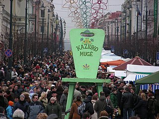
Kaziuko mugė or Saint Casimir's Fair is a large annual folk arts and crafts fair in Lithuania, dating to the beginning of the 17th century. The fair is traditionally held in city's markets and streets on the Sunday nearest to 4 March, the anniversary of Saint Casimir's death. In Lithuanian, Kaziukas is a diminutive of Casimir. Today, Saint Casimir's fair also features music, dance, theater performances; it attracts tens of thousands of visitors and many craftsmen from across Lithuania as well as from neighbouring countries such as Latvia, Russia, and Poland. In recent years, the fair has expanded into other cities in Lithuania, Belarus, Poland.

Neman, Niemen or Nemunas is a river in Europe that rises in central Belarus and flows through Lithuania then forms the northern border of Kaliningrad Oblast, Russia's western exclave, which specifically follows its southern channel. It drains into the Curonian Lagoon, narrowly connected to the Baltic Sea. The 937 km (582 mi) long Neman is a major Eastern European river. It flows generally west to Grodno within 12 kilometres (7.5 mi) of the Polish border, north to Kaunas, then westward again to the sea.

The river Neris or Vilija rises in northern Belarus. It flows westward, passing through Vilnius and in the south-centre of that country it flows into the Nemunas (Neman) from the right bank, at Kaunas, as its main tributary. Its length is 510 km (320 mi).

Lake Narach is a lake in northwestern Belarus, located in the basin of the Viliya river. It is the largest lake in Belarus.

Vilnius Region[a] is the territory in present-day Lithuania and Belarus that was originally inhabited by ethnic Baltic tribes and was a part of Lithuania proper, but came under East Slavic and Polish cultural influences over time.

Vilnius District Municipality is one of the 60 municipalities in Lithuania. It surrounds the capital city of Vilnius on three sides. The municipality is also bordered by Trakai district and Elektrėnai municipality in the west, Astravyets and Ashmyany districts of Belarus in the east, Širvintos, Molėtai and Švenčionys districts in the north and Šalčininkai district in the south.

Šalčininkai District Municipality is one of 60 district municipalities in Lithuania. The municipality is part of the Vilnius County and is located in southeastern Lithuania, next to the Belarus–Lithuania border. The south-eastern border of the municipality with Belarus includes a distinctive salient of Lithuanian territory, known as the Dieveniškės appendix, almost completely surrounded by Belarus.

Užupis is a neighborhood in Vilnius, the capital of Lithuania, largely located in Vilnius's old town, a UNESCO World Heritage Site. Užupis means "beyond the river" or "the other side of the river" in the Lithuanian language and refers to the Vilnia River; the name Vilnius was derived from the Vilnia. The district has been popular with artists for some time, and has been compared to Montmartre in Paris and to Freetown Christiania in Copenhagen, due to its bohemian and laissez-faire atmosphere. On April 1, 1997, the district declared itself an independent republic, with its own constitution.
Grigiškės is a city in the Vilnius city municipality, Lithuania. It is an industrial town with AB Grigiškės, a major paper factory built in 1923. Grigiškės is situated on both banks of the Vokė river, south of the river Neris.

The Nevėžis is the sixth longest river in Lithuania and one of the main tributaries of the Nemunas. The 209 km (130 mi) long Nevėžis flows entirely within Lithuania. Among the rivers that flow exclusively within Lithuania's borders, the Nevėžis is the second longest, after the Šventoji. Its source is in the Anykščiai District Municipality. The river first flows in a northwesterly direction, but at Panevėžys it turns southwest, and passing Kėdainiai, flows into the Neman just west of Kaunas near Raudondvaris.
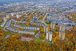
Žirmūnai is the most populous administrative division (elderate) in Vilnius. It is also a neighbourhood in the Lithuanian capital city Vilnius, encompassing the city district of the same name, built in the 1960s.
The Kotra is a 109-kilometre-long (68 mi) river in Belarus and Lithuania. The river is an example of a rare phenomenon of river bifurcation.

The Merkys is a river in southern Lithuania and northern Belarus. It flows for 13 km (8 mi) through Belarus, 5 km (3 mi) along the Belarusian–Lithuanian border, and 195 km (121 mi) through Lithuania before joining the Nemunas from the right bank near Merkinė.

Kalnai Park is a 24.5-hectare (61-acre) park between the left bank of the Neris River and right bank of the Vilnia River in Vilnius, Lithuania. It lies within the Vilnius Old Town elderate near Gediminas Hill and Gediminas Tower, and is part of the State Cultural Reserve of Vilnius Castles, established in 1997. The park hosts various events, including concerts, political rallies, and sporting competitions. Its name reflects the presence of four prominent hills (kalnai): Crooked Hill, Table Hill, Bekes Hill, and the Hill of Gediminas's Grave.

The Belarus–Lithuania border is an international border almost 678.8 km (421.8 mi) in length between the Republic of Belarus and the Republic of Lithuania. It is an external border of the European Union as well as the western border of the Commonwealth of Independent States. 379.9 km (236.1 mi) of the border is on land, while 298.9 km (185.7 mi) are on water, crossing lakes, e.g. Lake Drūkšiai and following some rivers, e.g. Dysna River and Neman River.

Litvinism is a pseudohistorical branch of nationalism, philosophy and political current in Belarus, which bases the history of its state on the heritage of the Grand Duchy of Lithuania and emphasizes the Baltic component of the Belarusian ethnic group. According to this branch of Belarusian nationalism, the Grand Duchy of Lithuania was a Slavic or Belarusian state, the medieval Lithuanians were Belarusians, and modern Lithuania is a consequence of a falsification of history. On the other hand, some Russian Litvinists refer to the Grand Duchy of Lithuania as a Slavic Russian state.

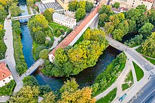
Castle Hill or Gediminas' Hill is a hill in Vilnius, Lithuania at the confluence of Neris and Vilnia rivers on the left side of the Vilnia. It is best known as the location of the Gediminas' Tower, a signature landmark of Vilnius, a remnant of the fortified Upper Castle dating to the Middle Ages. Castle Hill is part of the Vilnius Castles Cultural Reserve.
The demographic history of Vilnius goes back to the times after the Last Glacial Period some 12 thousand years ago.