Claiborne is an unincorporated community and census-designated place (CDP) in Ouachita Parish, Louisiana, United States. The population was 9,830 at the 2000 census. It is part of the Monroe Metropolitan Statistical Area.
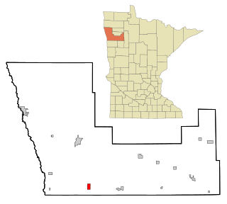
Beltrami is a city in Polk County, Minnesota, United States and was named in honor of Giacomo Costantino Beltrami, an Italian exile, who traveled to the Red river and the upper Mississippi in 1823. Officially incorporated in 1902, there had been settlers in the area since 1870. It is part of the Grand Forks, ND-MN Metropolitan Statistical Area. The population was 88 at the 2020 census.

Derry Township is a township in Montour County, Pennsylvania, United States.

East Manchester Township is a township in York County, Pennsylvania, United States. As of the 2020 census, the township population was 8,327.
Adjala–Tosorontio is a township in south-central Ontario, Canada, in the County of Simcoe.

Primorje-Gorski Kotar County is a county in western Croatia, most of it based in the historical and cultural region called Croatia proper and some of it in Istria, that includes the Bay of Kvarner, the surrounding Northern Croatian Littoral, and the mountainous region of Gorski kotar. Its center is Rijeka. The county's population was 296,195 at the 2011 census.
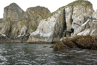
The Shumagin Islands are a group of 20 islands in the Aleutians East Borough south of the mainland of Alaska, United States, at 54°54'–55°20' North 159°15'–160°45' West. The largest islands are Unga Island, Popof Island, Korovin Island, and Nagai Island. Other islands include Andronica, Big Koniuji, Little Koniuji, Simeonof, Chernabura, and Bird. The total land area is 1,192.369 km2 and their total population as of the 2020 census was 578 persons, almost entirely in the city of Sand Point, on Popof Island.

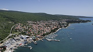
Kraljevica is a town in the Kvarner region of Croatia, located between Rijeka and Crikvenica, approximately thirty kilometers from Opatija and near the entrance to the bridge to the island of Krk. The population of the settlement of Kraljevica itself is 2,857 with a total of 4,618 in the area of the Town of Kraljevica, which is part of Primorje-Gorski Kotar County, and includes Šmrika. The town is known for its shipyard which has built a number of ships for the Croatian navy.

Delnice is a town in western Croatia, the largest settlement in the mountainous region of Gorski Kotar, in the Primorje-Gorski Kotar County. The town has a population of 4,379, and total municipality population is 5,952 (2011). Delnice is Gorski Kotar's main town.

Hum is a settlement, administratively located in the town of Buzet, in the central part of Istria, Croatia. The elevation is 349 m.
Punat is a municipality in the Primorje-Gorski Kotar County in western Croatia on the island of Krk. The municipality has a population of 1,900, with 90% Croats (2021). With Stara Baška being the only other settlement in the municipality, the village of Punat itself has a population of 1,784. The town first appears in writings from 1377 AD, but the exact date of its foundation is not known. In the bay, there is the little island of Košljun.
Kosančić is a village in Serbia. It is situated in the Vrbas municipality, South Bačka District, Vojvodina province. The village has a Serb ethnic majority and its population numbering 163 people.
Nemetin is a village in eastern Slavonia, Croatia, located near Osijek. It has a population of 139. It is administratively located in the City of Osijek.

Lokve is a Croatian municipality of Primorje–Gorski Kotar County. With an area of 42 km2, it has a population of 1,049.
Veleškovec is a village in Croatia. It is connected by the D24 highway.
Dol Klanječki is a village in Croatia. It is connected by the D205 highway.

Retkovci is a village in Croatia.

Rokovci is a village in eastern Croatia in the Andrijaševci Municipality of Vukovar-Syrmia County.
Gornja Topličica is a settlement (naselje) in the Sveti Ivan Zelina administrative territory of Zagreb County, Croatia. As of 2011 it had a population of 157 people.
Laktec is a settlement (naselje) in the Sveti Ivan Zelina administrative territory of Zagreb County, Croatia. As of 2011 it had a population of 175 people.
