Vrčin

Last updated • 3 min readFrom Wikipedia, The Free Encyclopedia
Vrčin
Врчин
Vrcin countryside.jpg
Only 20 km from the capital center, Vrčin is a peaceful village with a stunning countryside
Coordinates: 44°40′N20°36′E / 44.667°N 20.600°E / 44.667; 20.600
CountrySerbia
Subdivision Belgrade
Municipality Grocka
Population
 (2022)
  Total8,601
Area code +381(0)11

Vrčin (Serbian Cyrillic: Врчин) is a suburban settlement of Belgrade, Serbia. It is located in Belgrade's municipality of Grocka.

Contents

Name

Though the village itself was mentioned much later, historians Dušan J. Popović and Vladimir Ćorović traced the name of the locality back to the Roman period and the nearby temple of [N]orcinium. It was dedicated to the Etruscan-Roman goddess of destiny, Nortia. After Slavic settlement, Roman names ending with -cin[ium] were mostly contracted to čin, while suffix -dunum was morphed into din. [N]orcinium was thus shortened to [N]orčin and then modified to Vrčin. [1]

Geography

Roadway sign Beograd in 25.jpg
Roadway sign

Vrčin is located southeast of Avala mountain, in the central-eastern part of the municipality, 20 km southeast of Belgrade and 14 km west of the municipal seat of Grocka. It is situated in the spring area of the Bolečica river and is a major crossroad located on the Belgrade-Požarevac railway, the Belgrade-Niš highway, a regional road connecting the highway and the road of Smederevski put (through Zaklopača) and another one connecting the highway and the Belgrade-Kragujevac road.

Neighborhoods

Vrčin has several neighborhoods of its own. They can be roughly divided into two sections, north and south of the highway.

North section:

South section:

Economy

Despite the recent development of workshops and the commercial sector (including the building of a shopping mall in the center of the settlement), the economy is mostly based on agriculture.

Politics

Vrčin was once the seat of its own municipality, which was disbanded and incorporated into the municipality of Grocka.

Population

Vrčin is statistically classified as a rural settlement (village) and officially is the second most populous settlement in the municipality (Census 2002; after Kaluđerica but ahead of the municipal seat of Grocka). However, unofficial estimates that include refugees (not counted in the official census reports) also put Leštane before Vrčin.

Vrčin extends on both sides of the highway (originally developed from the western side). The eastern extension is colloquially known as Tranšped (Cyrillic: Траншпед). This area forms a continuous build-up area with Zaklopača. Vrčin has experienced a steady growth of population: [2]

Related Research Articles

<span class="mw-page-title-main">Kaluđerica</span> Urban neighbourhood in Grocka, Belgrade, Serbia

Kaluđerica is an urban neighborhood of Belgrade, Serbia. It is located in the municipality of Grocka.

This article deals with the system of transport in Belgrade, both public and private.

<span class="mw-page-title-main">Avala</span> Mountain in Serbia

Avala is a mountain in Serbia, overlooking Belgrade. It is situated in the south-eastern corner of the city and provides a great panoramic view of Belgrade, Vojvodina and Šumadija, as the surrounding area on all sides is mostly lowlands. It stands at 511 metres (1,677 ft) above sea level, which means that it enters the locally defined mountain category just by 11 m (36 ft).

<span class="mw-page-title-main">Voždovac</span> Municipality in Belgrade, Serbia

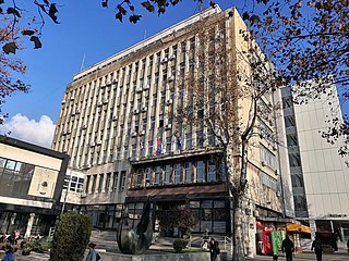
Voždovac is a municipality of the city of Belgrade. According to the 2022 census results, the municipality has a population of 174,864 inhabitants.

<span class="mw-page-title-main">Zvezdara</span> Municipality in Belgrade, Serbia

Zvezdara is a municipality of the city of Belgrade. The municipality is geographically hilly and with many forests. According to the 2022 census results, the municipality has a population of 172,625 inhabitants.

<span class="mw-page-title-main">Grocka</span> Municipality in Belgrade, Serbia

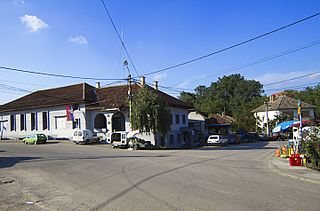
Grocka or Grocka na Dunavu is a municipality of the city of Belgrade. According to the 2022 census results, the municipality has 82,810 inhabitants.

Mali Mokri Lug is an urban neighborhood of Belgrade, Serbia. It is located in the south-eastern section of Belgrade's municipality of Zvezdara. It marks the border with the municipality of Grocka. It mostly stretches between Bulevar kralja Aleksandra and the Highway Belgrade–Niš, but also north of the boulevard. It extends into the neighborhoods of Mirijevo on the north, Konjarnik on the west, Medaković III on the south-west, Veliki Mokri Lug on the south and Kaluđerica on the east.

Bubanj Potok is a non-residential suburban settlement of Belgrade, the capital of Serbia. It is located in Belgrade's municipality of Voždovac.

<span class="mw-page-title-main">Begaljica</span> Rural settlement in Belgrade, Serbia

Begaljica ) is a rural settlement in the Grocka municipality of eastern Belgrade, Serbia. It is one of 15 settlements of Grocka, situated in its centre, with a population of 8,233 according to the 2011 preliminary census. The village is located at the water source of the Begaljica river, a tributary of the Danube, thus in the southern half of Podunavlje, as well as in the fertile Šumadija region of central Serbia.

<span class="mw-page-title-main">Brestovik</span> Suburban settlement in Serbia

Brestovik is a suburban settlement of Belgrade, the capital of Serbia. It is located in the municipality of Grocka.

<span class="mw-page-title-main">Kamendol</span> Suburban settlement in Serbia

Kamendol is a suburban settlement of Belgrade, the capital of Serbia. It is located in the Belgrade's municipality of Grocka.

<span class="mw-page-title-main">Pudarci</span> Suburban settlement in Serbia

Pudarci is a suburban settlement of Belgrade, the capital of Serbia. It is located in the Belgrade's municipality of Grocka.

Ritopek is a suburban settlement of Belgrade, Serbia. It is located in the municipality of Grocka, 20 km east of Belgrade and 19 km west of the municipal seat, on the right bank of the Danube, across from the village of Ivanovo in Banat region of the Vojvodina province.

<span class="mw-page-title-main">Umčari</span> Suburban settlement in Serbia

Umčari is a suburban settlement of Belgrade, the capital of Serbia. It is located in Belgrade's municipality of Grocka.

<span class="mw-page-title-main">Zaklopača (Grocka)</span> Suburban settlement of Belgrade, Serbia

Zaklopača is a suburban settlement of Belgrade, Serbia. It is located in Belgrade's municipality of Grocka.

<span class="mw-page-title-main">Živkovac</span>

Živkovac is a suburban settlement of Belgrade, the capital of Serbia. It is located in Belgrade's municipality of Grocka.

<span class="mw-page-title-main">Beli Potok (Belgrade)</span> Town in City of Belgrade, Serbia

Beli Potok is a small town and a suburban settlement of Belgrade, Serbia. It is located in Belgrade's municipality of Voždovac.

<span class="mw-page-title-main">Subdivisions of Belgrade</span> Administrative divisions of the City of Belgrade

Serbia's capital city of Belgrade is divided into 17 municipalities.

<span class="mw-page-title-main">Bolečica</span> River in Serbia

The Bolečica is a short river in north-central Serbia, a 12 km-long right tributary to the Danube. During its entire flow it runs through the suburban section of Belgrade and despite being short it flows through the three Belgrade's municipalities, next to the half dozen of suburbs of Belgrade with a total population of 35,000 and is a route to important roads.

Mala Pruga is an urban neighborhood of Belgrade, the capital of Serbia. It is located in Belgrade's municipality of Zemun.

References

  1. Dragan Stanković (17 October 2020). О називима појединих насеља око Београда[About names of some settlements around Belgrade]. Politika (in Serbian). p. 23.
  2. Uporedni pregled broja stanovnika 1948, 1953, 1961, 1971, 1981, 1991 i 2002 - podaci po naseljima (in Serbian). Belgrade: Republički zavod za statistiku. 2004. ISBN   86-84433-14-9.

Sources