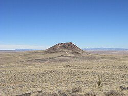
Vulcan (inactive volcano)

Last updated
Vulcan
Vulcan Volcano, Albuquerque NM.jpg
Highest point
Elevation 6,033 ft (1,839 m)
Prominence 600 ft (180 m)
Geography
Location Petroglyph National Monument Bernalillo County, New Mexico, U.S.
Geology
Age of rock > 10,000 years
Mountain type Spatter cone
Last eruption 150,000+ years ago

Vulcan, named after the Roman god of fire, is an inactive volcano on the West Mesa near Albuquerque, New Mexico. It is the largest of six volcanoes in the Albuquerque volcanic field within Petroglyph National Monument. Vulcan is a spatter cone volcano, formed primarily by lava fountains that were active in the central vent and in smaller vents on flanks of the cone. These flank vents formed the arches and caves seen today. It is believed to have last erupted around 150,000 years ago.

Contents

Description

Vulcan rises 600 feet (180 m) above the valley floor. From that vantage point, the alignment of the five-mile (8.0 km) long chain of vents is particularly noticeable. [1] Splatter forms when blobs of lava are emitted from a vent and cool as they fly through the air, and the partially molten blobs then land on the side of the cone to weld together to form a hard crust. Fragmented cinder and spatter material and lava flows dip at angles as high as 55° away from the central vent on the eastern and southern side of Vulcan. The spatter material is thickest on the southeastern side of Vulcan, indicating that it was blown by the wind toward the south and east during the fountaining events. A solidified lava pond that consists of a massive gray basalt with weakly developed columnar jointing occupies the crater of Vulcan. Radial, sinuous lava tubes 8 to 20 inches (200 to 510 mm) across and 300 feet (91 m) long are preserved on the northeast and northwest flanks of Vulcan. [2] [3]

Location

35°8′29.0″N106°46′19.1″W / 35.141389°N 106.771972°W / 35.141389; -106.771972

Vulcan lies in a large geological zone known as the Rio Grande rift, which follows the Rio Grande from southern Colorado through El Paso, Texas, after which it becomes indistinguishable from the Range and Basin province of northern Mexico. This rent in the Earth's surface, where two land masses are pulling away from one another, is responsible for much of the volcanic activity and mountain-building that occurs throughout the area.

Vulcan lies in Petroglyph National Monument, with access to the volcanoes during business hours, after which any vehicles are locked in and subject to fines and impound. It rests in a volcanic field approximately seven miles (11 km). northwest of Albuquerque. To the south are the volcanoes Black, followed by JA volcano. To the north lie Bond and Butte volcanoes and the Jemez Mountains. To the west is the giant stratovolcano Mount Taylor (Navajo: Tsoodził, The Turquoise Mountain), and to the east are the cities of Rio Rancho, Albuquerque, the village of Corrales, and the Sandia Mountains.

History

Vulcan is believed to have last erupted around 150,000 years ago. The volcanoes of the field are classified as inactive (or dormant). Earth and space-based geodetic measurements indicate ongoing surface uplift above the Socorro Magma Body at approximately two millimetres (0.1 in)/year. [4]

From 1951 to 1973, a large letter J representing the College of St. Joseph on the Rio Grande (later renamed the University of Albuquerque) was painted on the eastern slope of the volcano. Because of this, Vulcan was also sometimes referred to as the "J Volcano" or "J Cone." [5] The J was repainted each fall by the college's incoming freshman class. [6] In 1973, the J was "erased" by painting over the whitewash with a dark-colored stain, [5] though it is still faintly visible.

Related Research Articles

<span class="mw-page-title-main">Volcano</span> Rupture in the crust of a planet that allows lava, ash, and gases to escape from below the surface

A volcano is a rupture in the crust of a planetary-mass object, such as Earth, that allows hot lava, volcanic ash, and gases to escape from a magma chamber below the surface.

<span class="mw-page-title-main">Lava Beds National Monument</span> National monument in California, United States

Lava Beds National Monument is located in northeastern California, in Siskiyou and Modoc counties. The monument lies on the northeastern flank of Medicine Lake Volcano, which is the largest volcano by area in the Cascade Range.

<span class="mw-page-title-main">Volcanic cone</span> Landform of ejecta from a volcanic vent piled up in a conical shape

Volcanic cones are among the simplest volcanic landforms. They are built by ejecta from a volcanic vent, piling up around the vent in the shape of a cone with a central crater. Volcanic cones are of different types, depending upon the nature and size of the fragments ejected during the eruption. Types of volcanic cones include stratocones, spatter cones, tuff cones, and cinder cones.

<span class="mw-page-title-main">Geology of the Lassen volcanic area</span> Geology of a U.S. national park in California

The Lassen volcanic area presents a geological record of sedimentation and volcanic activity in and around Lassen Volcanic National Park in Northern California, U.S. The park is located in the southernmost part of the Cascade Mountain Range in the Pacific Northwest region of the United States. Pacific Oceanic tectonic plates have plunged below the North American Plate in this part of North America for hundreds of millions of years. Heat and molten rock from these subducting plates has fed scores of volcanoes in California, Oregon, Washington and British Columbia over at least the past 30 million years, including these in the Lassen volcanic areas.

<span class="mw-page-title-main">Medicine Lake Volcano</span> Shield volcano in northeastern California, United States

Medicine Lake Volcano is a large shield volcano in northeastern California about 30 mi (50 km) northeast of Mount Shasta. The volcano is located in a zone of east-west crustal extension east of the main axis of the Cascade Volcanic Arc and the Cascade Range. The 0.6 mi (1 km) thick shield is 22 mi (35 km) from east to west and 28 to 31 mi from north to south, and covers more than 770 sq mi (2,000 km2). The underlying rock has downwarped by 0.3 mi (0.5 km) under the center of the volcano. The volcano is primarily composed of basalt and basaltic andesite lava flows, and has a 4.3 by 7.5 mi caldera at the center.

<span class="mw-page-title-main">Petroglyph National Monument</span> United States National Monument and archeological site in New Mexico

Petroglyph National Monument stretches 17 miles (27 km) along Albuquerque, New Mexico's West Mesa, a volcanic basalt escarpment that dominates the city's western horizon. Authorized June 27, 1990, the 7,236 acres (2,928 ha) monument is cooperatively managed by the National Park Service and the City of Albuquerque. The western boundary of the monument features a chain of dormant fissure volcanoes. Beginning in the northwest corner, Butte volcano is followed to its south by Bond, Vulcan, Black and JA volcanoes.

<span class="mw-page-title-main">Anahim Volcanic Belt</span> Chain of volcanoes and related magmatic features in British Columbia, Canada

The Anahim Volcanic Belt (AVB) is a west–east trending chain of volcanoes and related magmatic features in British Columbia, Canada. It extends from Athlone Island on the Central Coast, running eastward through the strongly uplifted and deeply dissected Coast Mountains to near the community of Nazko on the Interior Plateau. The AVB is delineated as three west-to-east segments that differ in age and structure. A wide variety of igneous rocks with differing compositions occur throughout these segments, comprising landforms such as volcanic cones, volcanic plugs, lava domes, shield volcanoes and intrusions.

<span class="mw-page-title-main">Taos Plateau volcanic field</span> Volcanic field in New Mexico and Colorado

The Taos Plateau volcanic field is an area of extensive volcanism in Taos County, New Mexico, United States. It is the largest volcanic field in the Rio Grande Rift, spreading over 7,000 square kilometers (2,700 sq mi). The total erupted volume is estimated at 420 cubic kilometers (100 cu mi). The age of most of the vents and associated lava flows in the field is estimated to be between 1.8 and 4 million years, with a few 22-million-year-old vents. The composition of the lavas varies from tholeiitic basalt to rhyolite. Landforms include sheet flows, cinder cones, and shield volcanoes. The sheet flows of the Servilleta Basalt are well-exposed in the Rio Grande Gorge carved by the Rio Grande. The highest point of the field is San Antonio Mountain at 10,908 feet (3,325 m).

<span class="mw-page-title-main">Fissure vent</span> Linear volcanic vent through which lava erupts

A fissure vent, also known as a volcanic fissure, eruption fissure or simply a fissure, is a linear volcanic vent through which lava erupts, usually without any explosive activity. The vent is often a few metres wide and may be many kilometres long. Fissure vents can cause large flood basalts which run first in lava channels and later in lava tubes. After some time, the eruption tends to become focused at one or more spatter cones. Small fissure vents may not be easily discernible from the air, but the crater rows or the canyons built up by some of them are.

<span class="mw-page-title-main">Jornada del Muerto Volcano</span> Volcano in New Mexico, United States

The Jornada del Muerto Volcano is a small shield volcano and lava field in central New Mexico, about 10 by 15 miles in size and reaching an elevation of 5,136 feet (1,565 m). Jornada del Muerto means "Dead Man's Route" in Spanish, referring to the desolate colonial era trail from New Spain through this Malpaís region.

<span class="mw-page-title-main">Cinder cone</span> Steep hill of pyroclastic fragments around a volcanic vent

A cinder cone is a steep conical hill of loose pyroclastic fragments, such as volcanic clinkers, volcanic ash, or scoria that has been built around a volcanic vent. The pyroclastic fragments are formed by explosive eruptions or lava fountains from a single, typically cylindrical, vent. As the gas-charged lava is blown violently into the air, it breaks into small fragments that solidify and fall as either cinders, clinkers, or scoria around the vent to form a cone that often is symmetrical; with slopes between 30 and 40°; and a nearly circular ground plan. Most cinder cones have a bowl-shaped crater at the summit.

<span class="mw-page-title-main">Zuni-Bandera volcanic field</span> Volcanic field in New Mexico, United States

Zuni-Bandera volcanic field is a volcanic field located in the state of New Mexico, United States.

<span class="mw-page-title-main">Raton-Clayton volcanic field</span> Volcanic field in New Mexico, United States

The Raton-Clayton volcanic field is a volcanic field located in the state of New Mexico, United States. Capulin Volcano National Monument is located in the volcanic field. It is the northeasternmost volcanic field of the Jemez Lineament and the easternmost Cenozoic volcanic field of North America.

<span class="mw-page-title-main">San Felipe volcanic field</span> Volcanic field in northern New Mexico, US

San Felipe volcanic field is a monogenetic volcanic field located just north of the confluence of the Jemez River and the Rio Grande in New Mexico, US.

<span class="mw-page-title-main">Albuquerque volcanic field</span> Volcanic field in the Albuquerque Basin in New Mexico, United States

The Albuquerque volcanic field is a monogenetic volcanic field in the Albuquerque Basin in New Mexico, United States. It is located about 7 miles (11 km) west of the city of Albuquerque, and is contained within the borders of Petroglyph National Monument. The field was active from 190,000 to 155,000 years ago and includes lava flows, cinder cones, and spatter cones. The oldest lava flows cover about 23 square miles (60 km2). The cones are aligned and possibly formed above two roughly north-south trending fissures. Vulcan is the highest feature. Its base is made of cinder, but the crater contains a lava dome that was cut by an explosive eruption.

<span class="mw-page-title-main">Potrillo volcanic field</span> Volcanic field in United States and Mexico

The Potrillo volcanic field is a monogenetic volcanic field located on the Rio Grande Rift in southern New Mexico, United States and northern Chihuahua, Mexico. The volcanic field lies 22 miles (35 km) southwest of Las Cruces, and occupies about 4,600 square kilometers (1,800 sq mi) near the U.S. border with Mexico.

Caja del Rio is a dissected plateau, of volcanic origin, which covers approximately 84,000 acres of land in northern Santa Fe County, New Mexico, United States. The region is also known as the Caja, Caja del Rio Plateau, and Cerros del Rio. The center of the area is approximately 15 miles (23 km) west of Santa Fe, New Mexico. Most of the Caja is owned by the United States Forest Service and managed by the Santa Fe National Forest. Access is through New Mexico Highway 599, Santa Fe County Road 62, and Forest Service Road 24.

<span class="mw-page-title-main">JA volcano</span> Volcano in New Mexico, United States

JA Volcano is an inactive volcano located near Albuquerque, New Mexico. JA Volcano is the southernmost of 5 volcanoes in a 5-mile chain within the western boundary of Petroglyph National Monument.

<span class="mw-page-title-main">Black Volcano</span> A small volcano near Albuquerque, New Mexico, US

Black Volcano is an inactive volcano located near Albuquerque, New Mexico, and is part of the Albuquerque volcanic field. Black Volcano is located directly north of JA volcano. Black Volcano is the second of five volcanoes within the western boundary of Petroglyph National Monument. North of Black Volcano are Vulcan, Bond and Butte volcanoes. JA, Black, and Vulcan Volcanoes are located along a single fissure through which the lava erupted. The volcanoes are a rare example of a series of vents associated with a fissure eruption.

<span class="mw-page-title-main">Aden Crater</span> Volcano in New Mexico, United States

Aden Crater is a small shield volcano located in Doña Ana County, about 25 miles (40 km) southwest of Las Cruces, New Mexico. It is located in the northwest part of the Aden-Afton basalt field, which is part of the central area of the Potrillo volcanic field.

References

  1. US National Monuments.
  2. Smith, G.A., Florence, P.S., Castounis, A.D., Luongo, M., Moore, J.D., Throne, J., Zelley, K., 1999, Basaltic near-vent faces of Vulcan Cone, Albuquerque volcanoes, New Mexico New Mexico Geological Society Guidebook 50, p. 211-219.
  3. New Mexico Bureau of Geology and Mineral Resources
  4. Magma Uplift in New Mexico
  5. 1 2 Compton, K. C. (August 13, 1985). "'The Volcanoes' Have Names, But You Have To Dig". Albuquerque Journal. Retrieved July 31, 2021 via Newspapers.com.
  6. "UofA Freshmen Trek to Vulcan to Repaint 'J'". Albuquerque Journal. September 18, 1968. Retrieved July 31, 2021 via Newspapers.com.

Commons-logo.svg Media related to Vulcan (inactive volcano) at Wikimedia Commons