
Ivanovo Oblast is a federal subject of Russia. It had a population of 927,828 as of the 2021 Russian Census.

Volgograd Oblast is a federal subject of Russia, located in the lower Volga region of Southern Russia. Its administrative center is Volgograd. The population of the oblast was 2,500,781 in the 2021 Census.

Lipetsk Oblast is a federal subject of Russia. Its administrative center is the city of Lipetsk. As of the 2021 Census, its population was 1,143,224.

Tambov Oblast is a federal subject of Russia. Its administrative center is the city of Tambov. As of the 2010 Census, its population was 1,091,994.

Smolensk Oblast, informally also called Smolenschina (Смоленщина), is a federal subject of Russia. Its administrative centre is the city of Smolensk. As of the 2021 Census, its population was 888,421.
Syzran is the third largest city in Samara Oblast, Russia, located on the right bank of Saratov Reservoir of the Volga River. Population: 165,725 (2021 Census); 178,750 (2010 Census); 188,107 (2002 Census); 174,335 (1989 Census).

Lipetsk, also romanized as Lipeck, is a city and the administrative center of Lipetsk Oblast, Russia, located on the banks of the Voronezh River in the Don basin, 438 kilometers (272 mi) southeast of Moscow. Population: 496,403 (2021 Census); 508,887 (2010 Census); 506,114 (2002 Census); 449,635 (1989 Census).

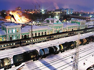
Megion is a town in Khanty-Mansi Autonomous Okrug–Yugra, Russia, located at the altitude of 45 meters (148 ft) above sea level, on the right bank of the Ob River, 380 kilometers (240 mi) east of Khanty-Mansiysk and 760 kilometers (470 mi) northeast of Tyumen. The area of the town is 50.51 square kilometers (19.50 sq mi) and the nearest airport is in Nizhnevartovsk. Population: 49,449 (2010 Census); 46,566 ; 39,783 (1989 Census).
Roza is an urban locality in Korkinsky District of Chelyabinsk Oblast, Russia. Population: 13,099 (2010 Census); 14,597 (2002 Census); 15,588 (1989 Census).

Ferzikovsky District is an administrative and municipal district (raion), one of the twenty-four in Kaluga Oblast, Russia. It is located in the east of the oblast. The area of the district is 1,249.9 square kilometers (482.6 sq mi). Its administrative center is the urban locality of Ferzikovo. As of the 2021 Census, the total population of the district was 17,557, with the population of Ferzikovo accounting for 25.5% of that number.

Sayansky District is an administrative and municipal district (raion), one of the forty-three in Krasnoyarsk Krai, Russia. It is located in the southeast of the krai and borders Rybinsky District in the north, Irbeysky District in the east, Irkutsk Oblast in the southeast, Kuraginsky District in the south, and Partizansky District in the west. The area of the district is 8,031 square kilometers (3,101 sq mi). Its administrative center is the rural locality of Aginskoye. As of the 2010 Census, the total population of the district was 12,002, with the population of Aginskoye accounting for 46.5% of that number.
Filyovsky Park District is a district of Western Administrative Okrug of the federal city of Moscow, Russia. The district is 6.5 km west of the center of the city, and its northern and eastern borders are the Moskva River. Located in the area are the Khrunichev State Research and Production Space Center, Church of the Intercession at Fili, Gorbunov Palace of Culture and Filevsky Park. The area of the district is 9.624 square kilometres (3.716 sq mi). Population: 89,513 (2010 Census);, 66,775 (2002 Census).

Khvastovichsky District is an administrative and municipal district (raion), one of the twenty-four in Kaluga Oblast, Russia. It is located in the south of the oblast. The area of the district is 1,410 square kilometers (540 sq mi). Its administrative center is the rural locality of Khvastovichi. As of the 2021 Census, the total population of the district was 9,888, with the population of Khvastovichi accounting for 44.8% of that number.

Kozelsky District is an administrative and municipal district (raion), one of the twenty-four in Kaluga Oblast, Russia. It is located in the southeast of the oblast. The area of the district is 1,523 square kilometers (588 sq mi). Its administrative center is the town of Kozelsk. Population: 38,596 (2021 Census); 41,802 (2010 Census); 44,775 ; 47,822 (1989 Census). The population of Kozelsk accounts for 43.4% of the district's total population.

Maloyaroslavetsky District is an administrative and municipal district (raion), one of the twenty-four in Kaluga Oblast, Russia. It is located in the northeast of the oblast. The area of the district is 1,547 square kilometers (597 sq mi). Its administrative center is the town of Maloyaroslavets. Population: 68,702 (2021 Census); 54,269 (2010 Census); 55,910 (2002 Census); 51,377 (1989 Census). The population of Maloyaroslavets accounts for 60.9% of the district's total population.

Mosalsky District is an administrative and municipal district (raion), one of the twenty-four in Kaluga Oblast, Russia. It is located in the west of the oblast. The area of the district is 1,320 square kilometers (510 sq mi). Its administrative center is the town of Mosalsk. Population: 9,131 (2021 Census); 9,094 (2010 Census); 10,357 ; 11,537 (1989 Census). The population of Mosalsk accounts for 46.4% of the district's total population.

Spas-Demensky District is an administrative and municipal district (raion), one of the twenty-four in Kaluga Oblast, Russia. It is located in the west of the oblast. The area of the district is 1,369 square kilometers (529 sq mi). Its administrative center is the town of Spas-Demensk. As of the 2021 Census, the total population of the district was 7,369, with the population of Spas-Demensk accounting for 62.0% of that number.
Belye Berega is an urban locality under the administrative jurisdiction of the town of oblast significance of Bryansk of Bryansk Oblast, Russia. Population: 7,412 (2021 Census); 9,642 (2010 Census); 10,637 (2002 Census); 10,759 (1989 Census).
Bolshoye Polpino is an urban locality under the administrative jurisdiction of the town of oblast significance of Bryansk of Bryansk Oblast, Russia. Population: 5,859 (2021 Census); 6,356 (2010 Census); 4,613 (2002 Census); 6,374 (1989 Census).
Raditsa-Krylovka is an urban locality under the administrative jurisdiction of the town of oblast significance of Bryansk of Bryansk Oblast, Russia. Population: 3,151 (2021 Census); 3,526 (2010 Census); 3,513 (2002 Census); 3,818 (1989 Census).


