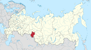
Oktyabrsky District, Khanty-Mansi Autonomous Okrug

Last updated
Oktyabrsky District
Октябрьский район(Russian)
RUS Oktiabr'skii raion location map.png
Location of Oktyabrsky District in Khanty–Mansi Autonomous Okrug
Coordinates: 62°27′N66°04′E / 62.450°N 66.067°E / 62.450; 66.067 Coordinates: 62°27′N66°04′E / 62.450°N 66.067°E / 62.450; 66.067
Oktyabrsky District - landscape.jpg
Landscape in Oktyabrsky District
Coat of Arms of Oktyabrsky rayon (Khanty-Mansyisky AO).png
Flag of Oktyabrsky rayon (Khanty-Mansia).png
Coat of arms
Flag
Location
Country Russia
Federal subject Khanty–Mansi Autonomous Okrug [1]
Administrative structure (as of December 2015)
Administrative center urban-type settlement of  Oktyabrskoye [1]
Inhabited localities: [1]
Urban-type settlements [2] 4
Rural localities 19
Municipal structure (as of December 2015)
Municipally incorporated asOktyabrsky Municipal District [3]
Municipal divisions: [3]
Urban settlements4
Rural settlements7
Statistics
Area (administrative district) 24,500 km2 (9,500 sq mi) [4]
Population (2010 Census) 32,224 inhabitants [5]
 Urban52.2%
 Rural47.8%
Population (January 2016 est.) 29,302 inhabitants [4]
Density 1.32/km2 (3.4/sq mi) [6]
Time zone YEKT (UTC+05:00) [7]
Established1937 [8]
Previous names Mikoyanovsky District (until November 28, 1957) [8]
Official website
Oktyabrsky District on WikiCommons
Population of Oktyabrsky District
2010 Census 32,224 [5]
2002 Census 29,283 [9]
1989 Census 34,739 [10]
1979 Census 27,182 [11]

Oktyabrsky District (Russian : Октя́брьский райо́н) is an administrative [1] and municipal [3] district (raion), one of the nine in Khanty-Mansi Autonomous Okrug of Tyumen Oblast, Russia. It is located in the western central part of the autonomous okrug. The area of the district is 24,500 square kilometers (9,500 sq mi). [4] Its administrative center is the urban locality (an urban-type settlement) of Oktyabrskoye. [1] As of the 2010 Census, the total population of the district was 32,224, with the population of Oktyabrskoye accounting for 11.3% of that number. [5]

Russian language East Slavic language

Russian is an East Slavic language, which is official in the Russian Federation, Belarus, Kazakhstan and Kyrgyzstan, as well as being widely used throughout Eastern Europe, the Baltic states, the Caucasus and Central Asia. It was the de facto language of the Soviet Union until its dissolution on 25 December 1991. Although nearly three decades have passed since the breakup of the Soviet Union, Russian is used in official capacity or in public life in all the post-Soviet nation-states, as well as in Israel and Mongolia.

A raion is a type of administrative unit of several post-Soviet states. The term is from the French "rayon", which is both a type of a subnational entity and a division of a city, and is commonly translated in English as "district".

Khanty-Mansi Autonomous Okrug First-level administrative division of Russia

Khanty-Mansi Autonomous Okrug – Yugra or Khanty-Mansiysk Autonomous Okrug – Yugra, is a federal subject of Russia. Population: 1,532,243.

Contents

History

The district was established as Mikoyanovsky District (Микояновский район) in 1937 within Ostyak–Vogul National Okrug of Omsk Oblast from parts of Beryozovsky and Kondinsky Districts. [8] It was given its present name on November 28, 1957. [8]

Omsk Oblast First-level administrative division of Russia

Omsk Oblast is a federal subject of Russia, located in southwestern Siberia. The oblast has an area of 139,700 square kilometers (53,900 sq mi). Its population is 1,977,665 with the majority, 1.15 million, living in Omsk, the administrative center.

Beryozovsky District, Khanty-Mansi Autonomous Okrug District in Khanty-Mansi Autonomous Okrug, Russia

Beryozovsky District is an administrative and municipal district (raion), one of the nine in Khanty-Mansi Autonomous Okrug of Tyumen Oblast, Russia. It is located in the northwest of the autonomous okrug on the left bank of meridional part of the Ob River within the limits of North Sosva altitudes and the east slope of the North and Pre-Polar Ural and borders with the Komi Republic in the west and with Shuryshkarsky District of Yamalo-Nenets Autonomous Okrug in the north. The area of the district is 90,000 square kilometers (35,000 sq mi). Its administrative center is the urban locality of Beryozovo. Population: 25,744 ; 27,170 (2002 Census); 28,256 (1989 Census). The population of Beryozovo accounts for 28.3% of the district's total population.

Kondinsky District District in Khanty–Mansi Autonomous Okrug, Russia

Kondinsky District is an administrative and municipal district (raion), one of the nine in Khanty-Mansi Autonomous Okrug of Tyumen Oblast, Russia. It is located in the south of the autonomous okrug. The area of the district is 55,170 square kilometers (21,300 sq mi). Its administrative center is the urban locality of Mezhdurechensky. Population: 34,494 ; 35,018 (2002 Census); 36,640 (1989 Census). The population of Mezhdurechensky accounts for 32.1% of the district's total population.

Related Research Articles

Nizhnevartovsk City in Khanty-Mansi Autonomous Okrug, Russia

Nizhnevartovsk is a city in Khanty-Mansi Autonomous Okrug, Russia. Since the 1960s, the Western Siberian oil boom led to Nizhnevartovsk's rapid growth from a small settlement to a city due to its location beside the Samotlor oil field along the right bank of the Ob River, 30 kilometers (19 mi) from the border with Tomsk Oblast, and the presence of the petroleum industry has made it one of the wealthiest cities in Russia.

Nyagan Town in Khanty-Mansi Autonomous Okrug, Russia

Nyagan is a town in the northwest of Khanty–Mansi Autonomous Okrug, Russia, located near the Ob River and 230 kilometers (140 mi) northwest of Khanty-Mansiysk. It is named after the Nyagan-Yugan River, a tributary of the Ob River. Population: 54,890 (2010 Census); 52,610 (2002 Census); 54,061 (1989 Census).

Yugorsk Town in Khanty-Mansi Autonomous Okrug, Russia

Yugorsk is a town in Khanty–Mansi Autonomous Okrug, Russia, located in the northwestern part of the East-West lowland, 420 kilometers (260 mi) from Khanty-Mansiysk. Population: 34,067 (2010 Census); 30,285 (2002 Census); 24,928 (1989 Census).

Sovetsky, Khanty-Mansi Autonomous Okrug Town in Khanty-Mansi Autonomous Okrug, Russia

Sovetsky is a town and the administrative center of Sovetsky District in Khanty-Mansi Autonomous Okrug, Russia, located 470 kilometers (290 mi) west of Khanty-Mansiysk, the administrative center of the autonomous okrug. Population: 26,495 (2010 Census); 23,230 (2002 Census); 21,123 (1989 Census).

Lyantor Town in Khanty-Mansi Autonomous Okrug, Russia

Lyantor is a town in Surgutsky District of Khanty–Mansi Autonomous Okrug, Russia, located on the Pim River, 625 kilometers (388 mi) northeast of Khanty-Mansiysk, the administrative center of the autonomous okrug. Population: 38,992 (2010 Census); 33,011 (2002 Census); 22,071 (1989 Census).

Langepas Town in Khanty-Mansi Autonomous Okrug, Russia

Langepas is a town in Khanty-Mansi Autonomous Okrug, Russia, located on the Kayukovskaya River 15 kilometers (9.3 mi) north of the right bank of the Ob River, 545 kilometers (339 mi) east of Khanty-Mansiysk, and 875 kilometers (544 mi) northeast of Tyumen. Population: 41,670 (2010 Census); 37,182 (2002 Census); 25,618 (1989 Census).

Pokachi Town in Khanty-Mansi Autonomous Okrug, Russia

Pokachi is a town in Khanty–Mansi Autonomous Okrug, Russia, located on the right bank of the Vatyegan River, 350 kilometers (220 mi) east of Khanty-Mansiysk and 800 kilometers (500 mi) northeast of Tyumen. Population: 17,171 (2010 Census); 17,017 (2002 Census); 11,536 (1989 Census).

Kogalym Town in Khanty-Mansi Autonomous Okrug, Russia

Kogalym is a town in Khanty-Mansi Autonomous Okrug, Russia, located on the Inguyagun River 325 kilometres (202 mi) northeast of Khanty-Mansiysk. Population: 58,181 (2010 Census); 55,367 (2002 Census); 44,297 (1989 Census).

Beloyarsky, Khanty-Mansi Autonomous Okrug Town in Khanty-Mansi Autonomous Okrug, Russia

Beloyarsky is a town and the administrative center of Beloyarsky District in Khanty-Mansi Autonomous Okrug, Russia, located on the Kazim River, northwest of Khanty-Mansiysk, the administrative center of the autonomous okrug. Population: 20,283 (2010 Census); 18,721 (2002 Census); 20,534 (1989 Census).

Raduzhny, Khanty-Mansi Autonomous Okrug Town in Khanty-Mansi Autonomous Okrug, Russia

Raduzhny is a town in Khanty-Mansi Autonomous Okrug, Russia, located on the Agan River, 475 kilometers (295 mi) northeast of Khanty-Mansiysk and 975 kilometers (606 mi) northeast of Tyumen. Population: 43,399 (2010 Census); 47,060 ; 43,726.

Pyt-Yakh Town in Khanty-Mansi Autonomous Okrug, Russia

Pyt-Yakh is a town in Khanty–Mansi Autonomous Okrug, Russia, located on the east bank of the Bolshoy Balyk River, southeast of Khanty-Mansiysk. Population: 41,488 (2010 Census); 41,813 (2002 Census); 17,101 (1989 Census).

Beloyarsky District, Khanty-Mansi Autonomous Okrug District in Khanty-Mansi Autonomous Okrug, Russia

Beloyarsky District is an administrative and municipal district (raion), one of the nine in Khanty-Mansi Autonomous Okrug of Tyumen Oblast, Russia. It is located in the north of the autonomous okrug. The area of the district is 41,574 square kilometers (16,052 sq mi). Its administrative center is the town of Beloyarsky. Population: 9,766 ; 9,493 (2002 Census); 8,927 (1989 Census).

Khanty-Mansiysky District District in Khanty-Mansi Autonomous Okrug, Russia

Khanty-Mansiysky District is an administrative and municipal district (raion), one of the nine in Khanty-Mansi Autonomous Okrug, Russia. It is located in the center of the autonomous okrug. The area of the district is 46,400 square kilometers (17,900 sq mi). Its administrative center is the town of Khanty-Mansiysk. As of the 2010 Census, the total population of the district was 19,362.

Nefteyugansky District District in Khanty-Mansi Autonomous Okrug, Russia

Nefteyugansky District is an administrative and municipal district (raion), one of the nine in Khanty-Mansi Autonomous Okrug, Russia. It is located in the south of the autonomous okrug. The area of the district is 24,550 square kilometers (9,480 sq mi). Its administrative center is the city of Nefteyugansk. Population: 44,815 ; 45,354 (2002 Census); 61,161 (1989 Census).

Nizhnevartovsky District District in Khanty-Mansi Autonomous Okrug, Russia

Nizhnevartovsky District is an administrative and municipal district (raion), one of the nine in Khanty-Mansi Autonomous Okrug, Russia. The area of the district is 118,500 square kilometers (45,800 sq mi). Its administrative center is the city of Nizhnevartovsk. Population: 35,745 ; 33,508 (2002 Census); 28,288 (1989 Census).

Sovetsky District, Khanty-Mansi Autonomous Okrug District in Khanty–Mansi Autonomous Okrug, Russia

Sovetsky District is an administrative and municipal district (raion), one of the nine in Khanty-Mansi Autonomous Okrug of Tyumen Oblast, Russia. It is located in the southwest of the autonomous okrug. The area of the district is 29,768.74 square kilometers (11,493.77 sq mi). Its administrative center is the town of Sovetsky. Population: 48,059 ; 44,720 (2002 Census); 73,247 (1989 Census). The population of the administrative center accounts for 55.1% of the district's total population.

Surgutsky District District in Khanty-Mansi Autonomous Okrug, Russia

Surgutsky District is an administrative and municipal district (raion), one of the nine in Khanty-Mansi Autonomous Okrug, Russia. It is located in the center of the autonomous okrug. The area of the district is 105,190 square kilometers (40,610 sq mi). Its administrative center is the city of Surgut. Population: 113,515 ; 106,624 (2002 Census); 74,685 (1989 Census).

Uray Town in Khanty-Mansi Autonomous Okrug, Russia

Uray is a town in Khanty–Mansi Autonomous Okrug, located on the Konda River 350 kilometers (220 mi) from Khanty-Mansiysk. Population: 39,457 (2010 Census); 38,872 (2002 Census); 37,198 (1989 Census).

Agirish Urban-type settlement in Khanty-Mansi Autonomous Okrug, Russia

Agirish is an urban-type settlement in Sovetsky District of Khanty-Mansi Autonomous Okrug, Russia. Population: 2,856 (2010 Census); 2,831 (2002 Census); 3,592 (1989 Census).

References

Notes

  1. 1 2 3 4 5 Law #43-oz
  2. The count of urban-type settlements may include the work settlements, the resort settlements, the suburban (dacha) settlements, as well as urban-type settlements proper.
  3. 1 2 3 Law #63-oz
  4. 1 2 3 Official website of Oktyabrsky District. General Information (in Russian)
  5. 1 2 3 Russian Federal State Statistics Service (2011). "Всероссийская перепись населения 2010 года. Том 1" [2010 All-Russian Population Census, vol. 1]. Всероссийская перепись населения 2010 года (2010 All-Russia Population Census) (in Russian). Federal State Statistics Service . Retrieved June 29, 2012.
  6. The value of density was calculated automatically by dividing the 2010 Census population by the area specified in the infobox. Please note that this value is only approximate as the area specified in the infobox does not necessarily correspond to the area of the entity proper or is reported for the same year as the population.
  7. Правительство Российской Федерации. Федеральный закон №107-ФЗ от 3 июня 2011 г. «Об исчислении времени», в ред. Федерального закона №271-ФЗ от 03 июля 2016 г. «О внесении изменений в Федеральный закон "Об исчислении времени"». Вступил в силу по истечении шестидесяти дней после дня официального опубликования (6 августа 2011 г.). Опубликован: "Российская газета", №120, 6 июня 2011 г. (Government of the Russian Federation. Federal Law #107-FZ of June 31, 2011 On Calculating Time , as amended by the Federal Law #271-FZ of July 03, 2016 On Amending Federal Law "On Calculating Time". Effective as of after sixty days following the day of the official publication.).
  8. 1 2 3 4 Official website of Oktyabrsky District. Historical Reference (in Russian)
  9. Russian Federal State Statistics Service (May 21, 2004). "Численность населения России, субъектов Российской Федерации в составе федеральных округов, районов, городских поселений, сельских населённых пунктов – районных центров и сельских населённых пунктов с населением 3 тысячи и более человек" [Population of Russia, Its Federal Districts, Federal Subjects, Districts, Urban Localities, Rural Localities—Administrative Centers, and Rural Localities with Population of Over 3,000](XLS). Всероссийская перепись населения 2002 года [All-Russia Population Census of 2002] (in Russian). Retrieved August 9, 2014.
  10. Demoscope Weekly (1989). "Всесоюзная перепись населения 1989 г. Численность наличного населения союзных и автономных республик, автономных областей и округов, краёв, областей, районов, городских поселений и сёл-райцентров" [All Union Population Census of 1989: Present Population of Union and Autonomous Republics, Autonomous Oblasts and Okrugs, Krais, Oblasts, Districts, Urban Settlements, and Villages Serving as District Administrative Centers]. Всесоюзная перепись населения 1989 года [All-Union Population Census of 1989] (in Russian). Институт демографии Национального исследовательского университета: Высшая школа экономики [Institute of Demography at the National Research University: Higher School of Economics]. Retrieved August 9, 2014.
  11. "Всесоюзная перепись населения 1979 г. Национальный состав населения по регионам России. (All Union Population Census of 1979. Ethnic composition of the population by regions of Russia.)". Всесоюзная перепись населения 1979 года (All-Union Population Census of 1979) (in Russian). Demoscope Weekly (website of the Institute of Demographics of the State University—Higher School of Economics. 1979. Retrieved 2008-11-25.

Sources