
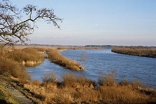
The river Warta rises in central Poland and meanders greatly north-west to flow into the Oder, against the German border. About 808.2 kilometres (502.2 mi) long, it is Poland's second-longest river within its borders after the Vistula, and third-longest including the Oder, that flows also across Czech Republic and Germany. Its drainage basin covers 54,529 square kilometers (21,054 sq mi) and it is navigable from Kostrzyn nad Odrą to Konin, approximately half of its length. It is connected to the Vistula by the Noteć and the Bydgoszcz Canal near the city of Bydgoszcz.

The Songhua or Sunghwa River is one of the primary rivers of China, and the longest tributary of the Amur. It flows about 1,434 kilometers (891 mi) from the Changbai Mountains on the China–North Korea border through China's northeastern Jilin and Heilongjiang provinces.

The Nemunas,Nioman, Neman or Memel is a river in Europe that rises in central Belarus and flows through Lithuania then forms the northern border of Kaliningrad Oblast, Russia's western exclave, which specifically follows its southern channel. It drains into the Curonian Lagoon, narrowly connected to the Baltic Sea. It flows about 937 km (582 mi), so is considered a major Eastern European river. It flows generally west to Grodno within 12 kilometres (7.5 mi) of the Polish border, north to Kaunas, then westward again to the sea.

The Kura is an east-flowing river south of the Greater Caucasus Mountains which drains the southern slopes of the Greater Caucasus east into the Caspian Sea. It also drains the north side of the Lesser Caucasus while its main tributary, the Aras, drains the south side of those mountains. Starting in northeastern Turkey, it flows through Turkey to Georgia, then to Azerbaijan, where it receives the Aras as a right tributary, and enters the Caspian Sea at Neftçala. The total length of the river is 1,515 kilometres (941 mi).

Polesia, Polesie or Polesye is a natural and historical region that starts from the farthest edge of Central Europe and encompasses Eastern Europe, including Eastern Poland, the Belarus–Ukraine border region and Western Russia.

The Pripyat or Prypiat is a river in Eastern Europe, approximately 761 km (473 mi) long. It flows east through Ukraine, Belarus, and Ukraine again, draining into the Dnieper.

Kaluga Oblast is a federal subject of Russia. Its administrative center is the city of Kaluga. The 2010 Russian Census found a population of 1,010,930.

Oryol Oblast, also known as Orlovshchina is a federal subject of Russia. Its administrative center is the city of Oryol. Population: 724,686.
The Bug or Western Bug is a major river mostly located in Eastern Europe, which flows through three countries with a total length of 774 kilometres (481 mi).
The Mukhavets is a river in western Belarus, a tributary to the Bug.
There are currently 64 national parks in Russia, a list of 48 of which is given below. Together they cover approximately 155,672 square kilometers (60,105 sq mi).
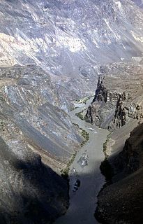
The Bartang is a river of Central Asia, tributary to the Panj and consequently to the Amu Darya. In its upper reaches, it is also known as the Murghab and Aksu; it flows through the Wakhan in Afghanistan, then through the Rushon District of the Gorno-Badakhshan autonomous region, Tajikistan. The river is 528 kilometres (328 mi) long and has a basin area of 24,700 square kilometres (9,500 sq mi).

The Zhizdra is a river in Kaluga Oblast in Russia, Oka's left tributary. The length of the river is 223 kilometres (139 mi). The area of its basin is 9,170 square kilometres (3,540 sq mi). The Zhizdra freezes up in late November and stays icebound until early April. Its main tributaries are the Resseta, Vytebet, and Seryona. The towns of Kozelsk and Zhizdra are located on the shores of the Zhizdra. The name is of Lithuanian origin. In Lithuanian, žizdras means 'thick sand, gravel'.
The Ubort is a river in the Zhytomyr Oblast (Ukraine) and the Homiel Voblast (Belarus), a right tributary to the Pripyat in the Dnieper river basin. It is 292 kilometres (181 mi) long, and has a drainage basin of 5,820 square kilometres (2,250 sq mi).

The Orlovskoye Polesye national park is a protected area in Russia.

The Pina is a river in Ivanava and Pinsk Raions in Belarus. The length of the river is 40 kilometers. The river flows into the city of Pinsk and is a left tributary of the Pripyat. The average gradient of Pina is 0.1 ‰. The largest tributaries are the Struha and Njaslucha. It forms part of the Dnieper-Bug Canal.

Znamensky District is an administrative and municipal district (raion), one of the twenty-four in Oryol Oblast, Russia. It is located in the northwest of the oblast. The area of the district is 817.1 square kilometers (315.5 sq mi). Its administrative center is the rural locality of Znamenskoye. Population: 5,016 ; 6,458 (2002 Census); 6,510 (1989 Census). The population of Znamenskoye accounts for 33.9% of the district's total population.

Khotynetsky District is an administrative and municipal district (raion), one of the twenty-four in Oryol Oblast, Russia.

Pasvik Nature Reserve is a bilateral nature reserve located in the valley of Pasvikdalen in Norway and Russia. The nature reserve was established in 1992 (Russia) and 1993 (Norway), and covers an area of 166.4 square kilometers (64.2 sq mi). The Norwegian part, in the municipality of Sør-Varanger, covers 19.1 square kilometers (7.4 sq mi), while the Russian part, in Pechengsky District, Murmansk Oblast, covers 147.3 square kilometers (56.9 sq mi). The nature reserve includes unexploited parts of Pasvikelva and has a rich birdlife.

Kaluzhskiye Zaseki Nature Reserve is a Russian zapovednik. Zaseki in Russian means abatises, field fortifications made of felled trees. In medieval times, the Kaluga region was part of the defensive line between the Russian forests to the north and potential invaders from the south. The reserve has been protected in some form for a thousand years, and remains old-growth forest. The reserve is situated in the Ulyanovsky District, Kaluga Oblast. It was formally established in 1992 and has an area of 18,533 hectares (71.56 sq mi).
