Aardenburg is a small city close to the Dutch border with Belgium. It is part of the Sluis Municipality, located in the province of Zeeland in the Netherlands. Its medieval name was Rodenburgh.

Atka Island is the largest island in the Andreanof Islands of the Aleutian Islands of Alaska. The island is 50 miles (80 km) east of Adak Island. It is 65 miles (105 km) long and 2–20 miles (3–30 km) wide with a land area of 404.6 square miles (1,048 km2), making it the 22nd largest island in the United States. The northeast of Atka Island contains the Korovin volcano which reaches a peak of 5,030 feet (1,533 m). Oglodak Island is located 3.4 miles off Cape Kigun, Atka's westernmost point.
Kiranipura is a census town in Ajmer district in the Indian state of Rajasthan.

Borzęcin is a village in the administrative district of Gmina Żmigród, within Trzebnica County, Lower Silesian Voivodeship, in south-western Poland. Prior to 1945 it was in Germany.
Massawa Subregion is a subregion in the Northern Red Sea region of Eritrea. Its capital lies at Massawa.
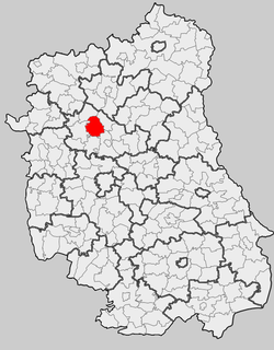
Poczekajka is a village in the administrative district of Gmina Żmudź, within Chełm County, Lublin Voivodeship, in eastern Poland.
Sierbowce is a village in the administrative district of Gmina Sokółka, within Sokółka County, Podlaskie Voivodeship, in north-eastern Poland, close to the border with Belarus. It lies approximately 6 kilometres (4 mi) north-west of Sokółka and 40 km (25 mi) north-east of the regional capital Białystok.
Sterpejki is a settlement in the administrative district of Gmina Kuźnica, within Sokółka County, Podlaskie Voivodeship, in north-eastern Poland, close to the border with Belarus. It lies approximately 7 kilometres (4 mi) north-west of Kuźnica, 20 km (12 mi) north of Sokółka, and 58 km (36 mi) north-east of the regional capital Białystok.
Bieliny is a village in the administrative district of Gmina Ulanów, within Nisko County, Subcarpathian Voivodeship, in south-eastern Poland. It lies approximately 7 kilometres (4 mi) south of Ulanów, 15 km (9 mi) south-east of Nisko, and 51 km (32 mi) north-east of the regional capital Rzeszów.
Dąbrowa Goszczewicka is a village in the administrative district of Gmina Potworów, within Przysucha County, Masovian Voivodeship, in east-central Poland.

Hang Mei Tsuen is an MTR Light Rail stop. It is located at ground level at Ping Ha Road near Hang Mei Tsuen in Ping Shan, Yuen Long District. It began service on 10 January 1993 and belongs to Zone 4.
Trojanówka is a village in the administrative district of Gmina Brzeźnica, within Żagań County, Lubusz Voivodeship, in western Poland.
Melanowo is a settlement in the administrative district of Gmina Chojnice, within Chojnice County, Pomeranian Voivodeship, in northern Poland. It lies approximately 11 kilometres (7 mi) south of Chojnice and 111 km (69 mi) south-west of the regional capital Gdańsk.
Osieki Słupskie is a village in the administrative district of Gmina Ustka, within Słupsk County, Pomeranian Voivodeship, in northern Poland. It lies approximately 16 kilometres (10 mi) east of Ustka, 16 km (10 mi) north of Słupsk, and 104 km (65 mi) west of the regional capital Gdańsk.
The Kampala Northern Bypass Highway, often referred to as the Northern Bypass, is a road in Uganda. It forms a semicircle across the northern suburbs of Kampala, Uganda's capital and largest city. The road was constructed to relieve traffic congestion within the city center, allowing cross-country traffic to bypass the city's downtown area.

Donji Vratari is a village in the municipality of Aleksandrovac, Serbia. According to the 2002 census, the village has a population of 297 people.
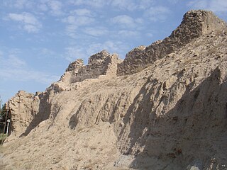
Rashkan Castle was a castle in Tehran Province in northern Iran. It was located near Cheshmeh Ali, Shah-Abdol-Azim shrine and Fath Ali shah inscription (Cheshmeh-Ali). The castle was intended to hold Rey, Iran. Rashkan castle was erected with plaster of lime and ashes or sand with stones. It was built during the Parthian rule of Persia.

The Oude molen does mean ''Old Mill'' in Dutch. Is a windmill in Kruiningen in the Dutch province of Zeeland.
Esbu is a village in Sajjadrud Rural District, Bandpey-ye Sharqi District, Babol County, Mazandaran Province, Iran. At the 2006 census, its population was 161, in 39 families.
Prisad is a village in Municipality of Prilep. The village, alongside with 3 other villages, are known for being the name of an Antarctic Island.