Skrzeszew is a village in the administrative district of Gmina Repki, within Sokołów County, Masovian Voivodeship, in east-central Poland. The village has a population of 460. It lies approximately 10 kilometres (6 mi) east of Repki, 19 km (12 mi) east of Sokołów Podlaski, and 106 km (66 mi) east of Warsaw.

Kożuchów is a village in the administrative district of Gmina Bielany, within Sokołów County, Masovian Voivodeship, in east-central Poland. It lies approximately 7 kilometres (4 mi) east of Bielany, 9 km (6 mi) south-east of Sokołów Podlaski, and 92 km (57 mi) east of Warsaw.
Kożuchówek is a village in the administrative district of Gmina Bielany, within Sokołów County, Masovian Voivodeship, in east-central Poland. It lies approximately 8 kilometres (5 mi) east of Bielany, 10 km (6 mi) south-east of Sokołów Podlaski, and 94 km (58 mi) east of Warsaw.
Kudelczyn is a village in the administrative district of Gmina Bielany, within Sokołów County, Masovian Voivodeship, in east-central Poland. It lies approximately 4 kilometres (2 mi) west of Bielany, 8 km (5 mi) south-west of Sokołów Podlaski, and 84 km (52 mi) east of Warsaw.
Baczki is a village in the administrative district of Gmina Repki, within Sokołów County, Masovian Voivodeship, in east-central Poland. It lies approximately 5 kilometres (3 mi) east of Repki, 15 km (9 mi) east of Sokołów Podlaski, and 101 km (63 mi) east of Warsaw.

Borychów is a village in the administrative district of Gmina Repki, within Sokołów County, Masovian Voivodeship, in east-central Poland. It lies approximately 12 kilometres (7 mi) south-east of Sokołów Podlaski and 97 km (60 mi) east of Warsaw.
Kamianka is a village in the administrative district of Gmina Repki, within Sokołów County, Masovian Voivodeship, in east-central Poland. It lies approximately 4 kilometres (2 mi) north of Repki, 11 km (7 mi) east of Sokołów Podlaski, and 98 km (61 mi) east of Warsaw.
Kanabród is a village in the administrative district of Gmina Repki, within Sokołów County, Masovian Voivodeship, in east-central Poland. It lies approximately 6 kilometres (4 mi) north-east of Repki, 13 km (8 mi) east of Sokołów Podlaski, and 101 km (63 mi) east of Warsaw.
Karskie is a village in the administrative district of Gmina Repki, within Sokołów County, Masovian Voivodeship, in east-central Poland. It lies approximately 7 kilometres (4 mi) east of Repki, 17 km (11 mi) east of Sokołów Podlaski, and 103 km (64 mi) east of Warsaw.
Kobylany Górne is a village in the administrative district of Gmina Repki, within Sokołów County, Masovian Voivodeship, in east-central Poland. It lies approximately 6 kilometres (4 mi) south of Repki, 12 km (7 mi) south-east of Sokołów Podlaski, and 94 km (58 mi) east of Warsaw.

Liszki is a village in the administrative district of Gmina Repki, within Sokołów County, Masovian Voivodeship, in east-central Poland. It lies approximately 8 kilometres (5 mi) east of Repki, 18 km (11 mi) east of Sokołów Podlaski, and 104 km (65 mi) east of Warsaw.
Ostrowiec is a village in the administrative district of Gmina Repki, within Sokołów County, Masovian Voivodeship, in east-central Poland. It lies approximately 8 kilometres (5 mi) east of Repki, 17 km (11 mi) east of Sokołów Podlaski, and 103 km (64 mi) east of Warsaw.
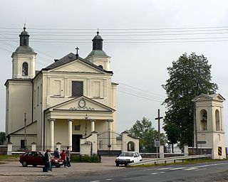
Repki is a village in Sokołów County, Masovian Voivodeship, in east-central Poland. It is the seat of the gmina called Gmina Repki. It lies approximately 10 kilometres (6 mi) east of Sokołów Podlaski and 96 km (60 mi) east of Warsaw.
Rogów is a village in the administrative district of Gmina Repki, within Sokołów County, Masovian Voivodeship, in east-central Poland. It lies approximately 5 kilometres (3 mi) north-west of Repki, 8 km (5 mi) east of Sokołów Podlaski, and 95 km (59 mi) east of Warsaw.
Rudniki is a village in the administrative district of Gmina Repki, within Sokołów County, Masovian Voivodeship, in east-central Poland. It lies approximately 12 kilometres (7 mi) east of Repki, 21 km (13 mi) east of Sokołów Podlaski, and 108 km (67 mi) east of Warsaw.
Skorupki is a village in the administrative district of Gmina Repki, within Sokołów County, Masovian Voivodeship, in east-central Poland. It lies approximately 3 kilometres (2 mi) south-west of Repki, 9 km (6 mi) south-east of Sokołów Podlaski, and 94 km (58 mi) east of Warsaw.
Wyrozęby-Podawce is a village in the administrative district of Gmina Repki, within Sokołów County, Masovian Voivodeship, in east-central Poland. It lies approximately 6 kilometres (4 mi) south-east of Repki, 15 km (9 mi) south-east of Sokołów Podlaski, and 99 km (62 mi) east of Warsaw.
Dolne Pole is a village in the administrative district of Gmina Sokołów Podlaski, within Sokołów County, Masovian Voivodeship, in east-central Poland. It lies approximately 8 kilometres (5 mi) south-west of Sokołów Podlaski and 81 km (50 mi) east of Warsaw.
Kosierady Wielkie is a village in the administrative district of Gmina Sokołów Podlaski, within Sokołów County, Masovian Voivodeship, in east-central Poland. It lies approximately 7 kilometres (4 mi) south-west of Sokołów Podlaski and 83 km (52 mi) east of Warsaw.


