
Anson County is a county located in the U.S. state of North Carolina. As of the 2020 census, the population was 22,055. Its county seat is Wadesboro.

Calloway County is a county located in the southwest portion of the U.S. Commonwealth of Kentucky. As of the 2020 census, the population was 37,103. Its county seat is Murray. The county was founded in November 1822 and named for Colonel Richard Callaway, one of the founders of Boonesborough. Calloway County comprises the Murray, KY Micropolitan Statistical Area. As of July 18, 2012 Calloway County is a moist county: the sale of alcohol in the county is prohibited, with the exception of the city of Murray.
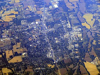
Murray is a home rule-class city in Calloway County, Kentucky, United States. It is the seat of Calloway County and the 19th-largest city in Kentucky. The city's population was 17,741 during the 2010 U.S. census, and its micropolitan area's population is 37,191. Murray is a college town and is the home of Murray State University.

Wadesboro is a town and the county seat of Anson County, North Carolina, United States. The population was 5,049 at the 2020 census. The town was originally found in 1783 as New Town but changed by the North Carolina General Assembly to Wadesboro in 1787 to honor Colonel Thomas Wade, a native son, state legislator, and Revolutionary War commander of the Anson County Regiment.
Fort Donelson National Battlefield preserves Fort Donelson and Fort Heiman, two sites of the American Civil War Forts Henry and Donelson Campaign, in which Union Army Brigadier General Ulysses S. Grant and Flag Officer Andrew Hull Foote captured three Confederate forts and opened two rivers, the Tennessee River and the Cumberland River, to control by the Union Navy. The commanders received national recognition for their victories in February 1862, as they were the first major Union successes of the war. The capture of Fort Donelson and its garrison by the Union led to the capture of Tennessee's capital and industrial center, Nashville, which remained in Union hands from February 25, 1862 until the end of the war, and gave the Union effective control over much of Tennessee. This struck a major blow to the Confederacy early in the war.

Linn Boyd was a prominent US politician of the 1840s and 1850s, and served as Speaker of the United States House of Representatives from 1851 to 1855. Boyd was elected to the House as a Jacksonian from Kentucky from 1835 to 1837 and again as a Democrat from 1839 to 1855, serving seven terms in the House. Boyd County, Kentucky is named in his honor.

Kentucky Route 80 (KY 80) is a 483.55-mile-long (778.20 km) state highway in the southern part of the U.S. state of Kentucky. The route originates on the state's western border at Columbus in Hickman County and stretches across the southern portion of the state, terminating southeast of Elkhorn City on the Virginia state line. It is the longest Kentucky State Highway, though the official distance as listed in route logs is much less due to multiple concurrencies with U.S. Route 68 (US 68) and US 23.
The United States District Court for the Western District of Kentucky is the federal district court for the western part of the state of Kentucky.
Calloway County High School is a public high school located in Murray, Kentucky, United States. The school was formed from the consolidation of six high schools from across the county: Hazel High School, Lynn Grove High School, Kirksey High School, Almo High School, New Concord High School, and Faxon High School.
The Calloway County School District is located in Calloway County, Kentucky, United States and is the educational home to over 3,000 students. The district operates Calloway County Preschool, three elementary schools, Calloway County Middle School, and Calloway County High School. Calloway County students and teams are referred to as "Lakers."

The Confederate Monument in Murray is a statue located in the northeast corner of the Calloway County Courthouse in Murray, Kentucky. It commemorates the 800 citizens of the county who served in the Confederate Army during the American Civil War, and is one of several Confederate monuments in Kentucky featuring Robert E. Lee. There is another one in Bardstown KY. Despite recent controversy, the Calloway County Fiscal Court voted to keep the statue on its grounds in July 2020.
This is a list of the National Register of Historic Places listings in Calloway County, Kentucky. It is intended to be a complete list of the properties and districts on the National Register of Historic Places in Calloway County, Kentucky, United States. The locations of National Register properties and districts for which the latitude and longitude coordinates are included below, may be seen in a map.

The 1996 United States presidential election in Kentucky took place on November 5, 1996, as part of the 1996 United States presidential election. Voters chose 8 representatives, or electors to the Electoral College, who voted for president and vice president.
The Backusburg Mounds (15-CW-64) are an archaeological site in the Jackson Purchase region of the U.S. state of Kentucky. Located near the tiny community of Backusburg in northwestern Calloway County, the mounds are one of the region's premier archaeological sites. Since at least the early years of the twentieth century, the mounds have been well known locally, due partially to their large size; the largest mound measures 150 by 75 feet at the base. Located on a ridgeline above a fork of the Clarks River, the mound bears a peculiar shape; its size and shape have caused observers to suggest that it might actually be the remnants of a series of smaller mounds placed next to each other. As late as the 1930s, this largest mound had never been plowed; it lay in dense woodland, and among the trees growing upon it were some of considerable size. Nevertheless, the mound has not been preserved entirely without damage; various parts of the mound have been dug into at various times and have yielded numerous artifacts. Such findings are not unprecedented in the area; a field close to Backusburg has long produced skeletons, projectile points, and pottery when plowed, leading to its identification as a former village site.

Kentucky Route 94 is a 79.816-mile-long (128.451 km) state highway in Kentucky that runs from Tennessee State Route 78 at the Tennessee state line to KY 80 southwest of the unincorporated community of Aurora via Hickman, Water Valley, and Murray.

Kentucky Route 299 (KY 299) is a 12.3-mile-long (19.8 km) state highway in the U.S. state of Kentucky. The highway connects mostly rural areas of Calloway and Marshall counties.
The 1972 United States presidential election in Kentucky took place on November 7, 1972, as part of the 1972 United States presidential election. Kentucky voters chose 9 representatives, or electors, to the Electoral College, who voted for president and vice president. These electors at the time were Frank Stubblefield (D), Romano L. Mazzoli (D), Gene Snyder (R), Tim Lee Carter (R), William P. Curlin Jr. (D), Carl D. Perkins (D), John Sherman Cooper (R), Marlow W. Cook (R).
Penny is an unincorporated community in Calloway County, Kentucky, United States.
Midway is an unincorporated community in Calloway County, Kentucky, United States.
Josh Calloway is an American politician serving as a member of the Kentucky House of Representatives from the 10th district. Elected in November 2020, he assumed office on January 1, 2021.


