Agastihal is a small village in the southern state of Karnataka, India. Administratively Agastihal is under Gundgurthi panchayat village, Wadgera Taluka of Yadgir district in Karnataka. Agastihal is 2.7 km by road southwest of Gundgurthi, and 7 km by road northeast of Hattigudur.
Agnihal is a village in the southern state of Karnataka, India. Administratively, it is under Gonal panchayat village, Wadgera Taluka of Yadgir district in Karnataka.
Hoskera is a panchayat village in Shahapur taluka of Yadgir district in Karnataka state, India. Hoskera is four kilometres by road north-northwest of Wanadurga, and just over eight kilometres south-southwest of Gogikona. The nearest railhead is in Yadgir.
Marnal (Maranal) is a panchayat village in Shorapur taluka of Yadgir district in Karnataka state, India. Marnal is 4 km southwest of Bardevanhal. The nearest railhead is in Yadgir.
Gundgurthi is a gram panchayat village in the southern state of Karnataka, India. Administratively, Gundgurthi is under Wadgera Taluka of Yadgir district in Karnataka. Gundgurthi is nine kilometers by road northeast of Hattigudur. The nearest railhead is in Yadgir.
Kachakanoor is a panchayat village in the southern state of Karnataka, India. Administratively, Kachakanoor is under Shorapur Taluka of Yadgir District in Karnataka. The village of Kachakanoor is 5 km by road east of the village of Yedhalli and 13 km by road west of the village of Peth Ammapur. The nearest railhead is in Yadgir.
Rastapur is a panchayat village in the southern state of Karnataka, India. Administratively, Rastapur is under Shahapur Taluka of Yadgir district in Karnataka. Rastapur is 6 km by road east of the village of Sagar and 6.5 km by road northwest of the village of Hattigudur. The nearest railhead is in Yadgir.
Ramasamudra is a panchayat village in the southern state of Karnataka, India. Administratively, Ramasamudra is under Yadgir Taluka of Yadgir District in Karnataka. The village of Ramasamudra is 6 km by road east of the village of Munderga, and 8.6 km by road west of the village of Paspool. The nearest railhead is in Yadgir.
Munderga is a panchayat village in the southern state of Karnataka, India. Administratively, Munderga is under Yadgir Taluka of Yadgir District in Karnataka. The village of Munderga is 6 km by road west of the village of Ramasamudra, and 5 km by road east of the town of Yadgir. The nearest railhead is in Yadgir.
Putpak is a panchayat village in the southern state of Karnataka, India. Administratively, Putpak is under Yadgir Taluka of Yadgir District in Karnataka. The village of Putpak is on the eastern edge of Yadgir District and Karnataka and is only 6 km by road west of the village of Damaragidda in Telangana. It is 10.5 km by road southeast of the town of Gurmatkal. The nearest railhead is in Yadgir.
Thangunda is a panchayat village in the southern state of Karnataka, India. Administratively, Thangunda is under Yadgir Taluka of Yadgir District in Karnataka. The village of Thangunda is 12 km by road northwest of the town of Yadgir. The nearest rail station is Thangunda Railway Station two kilometres to the east, while the nearest railhead is in Yadgir.
Bendebembli, is a panchayat village in the southern state of Karnataka, India. Administratively, Bendebembli is under the Wadgera, Taluka of Yadgir district in Karnataka. It lies on the left (east) bank of the Krishna River. Bendebembli is 10 km by road southeast of the village of Tumkur and 40 km by road south of the town of Yadgir. The nearest rail station is Chegunda Station and the nearest railhead is in Yadgir.
Gonal is a panchayat village in the southern state of Karnataka, India. Administratively since 2017, Gonal has been under the Wadgera Taluka of Yadgir district in Karnataka. It lies on the left (east) bank of the Krishna River. Gonal is nine kilometers by road southeast of the village of Bendebembli and thirteen kiolmeters by road southwest of the village of Badiyal. The nearest rail station is Chegunda Station and the nearest railhead is in Yadgir.
Badiyal is a panchayat village in the southern state of Karnataka, India. Administratively, Badiyal is under the Yadgir Taluka of Yadgir district in Karnataka. Badiyal is 13.5 km by road east of the village of Bendebembli and 41 km by road south of the town of Yadgir. The nearest rail station is Chegunda Station, and the nearest railhead is in Yadgir.
Tumkur is a gram panchayat village in the southern state of Karnataka, India. Administratively, it is under Wadgera Taluka of Yadgir district in Karnataka. It lies on the left (east) bank of the Krishna River. Tumkur is 10 km by road northwest of the village of Bendebembli and 31 km by road south of the town of Yadgir. The nearest rail station is Chegunda Station and the nearest railhead is in Yadgir. As a gram panchayat it oversees the villages of Itga Simt Wadgera and Habshihal.
Aldhal, is a panchayat village in the southern state of Karnataka, India. Administratively, Aldhal is under Shorapur Taluka of Yadgir District in Karnataka. The village of Aldhal is 12 km by road southwest of the town of Shorapur and 27 km by road east of the village of Wajjal. The nearest railhead is in Yadgir.
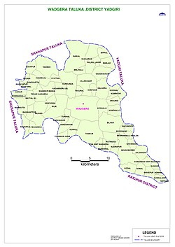
Wadgera is a panchayat village in the southern state of Karnataka, India. Administratively, Wadgera is under the Wadgera Taluka of Yadgir district in Karnataka. Wadgera is 23 km by road south of the town of Yadgir and 39 km by road southeast of the town of Shahapur. The nearest rail station is Narayanpet Road Station and the nearest railhead is in Yadgir.
Hayyal (B) is a panchayat village in the southern state of Karnataka, India. Administratively since 2017, Hayyal (B) has been under the Wadgera Taluka of Yadgir district in Karnataka. It lies on the left (east) bank of the Krishna River. Hayyal (B) is 26 kilometers by road southeast of the village of Bendebembli and 23 kiolmeters by road northwest of the City of Shahapur, Karnataka.and 18 kiolmeters by road northeast of the Taluka of Wadgera Taluka.and 39 kiolmeters by road northeast of the District of Yadgir. The nearest rail station is Yadgir Station and the nearest railhead is in Yadgir.
Madarkal,Wadgera is a village in the southern state of Karnataka, India. Administratively since 2017, Madarkal,Wadgera has been under the Wadgera Taluka of Yadgir district in Karnataka. It lies on the left (east) bank of the Krishna River. Madarkal is 4 kilometers by road southwest of the village of Hayyal (B), Wadgera and 24 kiolmeters by road northwest of the City of Shahapur, Karnataka.and 20 kiolmeters by road northeast of the Taluka of Wadgera Taluka.and 45 kiolmeters by road northeast of the District of Yadgir. The nearest rail station is Yadgir railway station and the nearest railhead is in Yadgir.
Ekchinti,Wadgera is a village in the southern state of Karnataka, India. Administratively since 2017, Ekchinti,Wadgera has been under the Wadgera Taluka of Yadgir district in Karnataka. It lies on the left (east) bank of the Krishna River. Ekchinti is 8 kilometers by road southwest of the village of Hayyal (B), Wadgera and 28 kiolmeters by road northwest of the City of Shahapur, Karnataka.and 24 kiolmeters by road northeast of the Taluka of Wadgera Taluka.and 49 kiolmeters by road northeast of the District of Yadgir. The nearest rail station is Yadgir railway station and the nearest railhead is in Yadgir.
