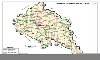
Shahapur is a city and taluka headquarter located in the Yadgir district of Indian state of Karnataka. Shahapur is 597 km north of Bangalore and well connected by road to Gulbarga (70 km), Hyderabad (240 km), Bidar (160 km), Raichur (90 km) and Yadgir (32 km).
Gogikona is a village in the southern state of Karnataka, India. It is located in the Shahapur taluka of Yadgir district in Karnataka. Gogikona is a companion village to Gogipeth which lies less than half a kilometre to the northwest, across a small stream, and together the two are often known as "Gogi".

Wadgera is a taluka panchayat in the southern state of Karnataka, India. Administratively, Wadgera is in the Yadgir district in Karnataka. It was created 2017 out of the southern portion of Shahapur Taluka. The administrative center is the village of Wadgera, 23 km by road south of the City of Yadgir and 39 km by road southeast of the town of Shahapur. The nearest rail station and the nearest railhead are in Yadgir.
Agastihal is a small village in the southern state of Karnataka, India. Administratively Agastihal is under Gundgurthi panchayat village, Wadgera Taluka of Yadgir district in Karnataka. Agastihal is 2.7 km by road southwest of Gundgurthi, and 7 km by road northeast of Hattigudur.
Agnihal is a village in the southern state of Karnataka, India. Administratively, it is under Gonal panchayat village, Wadgera Taluka of Yadgir district in Karnataka.
Wagingera is a village in the Shorapur taluka of Yadgir district in Karnataka state, India. Wagingera is famous for its fort that played decisive role during the Siege of Wagingera. Wagingera Fort is 5 km west of Shorapur city.
Hoskera is a panchayat village in Shahapur taluka of Yadgir district in Karnataka state, India. Hoskera is four kilometres by road north-northwest of Wanadurga, and just over eight kilometres south-southwest of Gogikona. The nearest railhead is in Yadgir.
Marnal (Maranal) is a panchayat village in Shorapur taluka of Yadgir district in Karnataka state, India. Marnal is 4 km southwest of Bardevanhal. The nearest railhead is in Yadgir.
Gundgurthi is a gram panchayat village in the southern state of Karnataka, India. Administratively, Gundgurthi is under Wadgera Taluka of Yadgir district in Karnataka. Gundgurthi is nine kilometers by road northeast of Hattigudur. The nearest railhead is in Yadgir.
Hattigudur is a panchayat village in the southern state of Karnataka, India. Administratively, Hattigudur is under Shahapur taluka of Yadgir district in Karnataka. Hattigudur is 12 km by road south of the town of Shahapur and 9 km by road southwest of Gundgurthi. The nearest railhead is in Yadgir.
Paspool is a panchayat village in the southern state of Karnataka, India. Administratively, it is under Yadgir taluka of Yadgir district in Karnataka. Paspool is twenty kilometres by road from the city of Yadgir. The nearest railhead is in Yadgir.
Rastapur is a panchayat village in the southern state of Karnataka, India. Administratively, Rastapur is under Shahapur Taluka of Yadgir district in Karnataka. Rastapur is 6 km by road east of the village of Sagar and 6.5 km by road northwest of the village of Hattigudur. The nearest railhead is in Yadgir.
Bendebembli, is a panchayat village in the southern state of Karnataka, India. Administratively, Bendebembli is under the Wadgera, Taluka of Yadgir district in Karnataka. It lies on the left (east) bank of the Krishna River. Bendebembli is 10 km by road southeast of the village of Tumkur and 40 km by road south of the town of Yadgir. The nearest rail station is Chegunda Station and the nearest railhead is in Yadgir.
Gonal is a panchayat village in the southern state of Karnataka, India. Administratively since 2017, Gonal has been under the Wadgera Taluka of Yadgir district in Karnataka. It lies on the left (east) bank of the Krishna River. Gonal is nine kilometers by road southeast of the village of Bendebembli and thirteen kiolmeters by road southwest of the village of Badiyal. The nearest rail station is Chegunda Station and the nearest railhead is in Yadgir.
Tumkur is a gram panchayat village in the southern state of Karnataka, India. Administratively, it is under Wadgera Taluka of Yadgir district in Karnataka. It is on the east bank of the Krishna River. Tumkur is 10 km by road northwest of the village of Bendebembli and 31 km by road south of the town of Yadgir. The nearest rail station is Chegunda Station and the nearest railhead is in Yadgir. As a gram panchayat it oversees the villages of Itga Simt Wadgera and Habshihal.
Aldhal is a village in the southern state of Karnataka, India. Administratively, it is under Kakkasgera panchayat village, Shahpur Taluka of Yadgir district in Karnataka. Aldhal is 5 km by road west of the village of Wanadurga and 9.5 km by road southwest of the village of Hoskera. The nearest railhead is in Yadgir.
Wadgera is a panchayat village in the southern state of Karnataka, India. Administratively, Wadgera is under the Wadgera Taluka of Yadgir district in Karnataka. Wadgera is 23 km by road south of the town of Yadgir and 39 km by road southeast of the town of Shahapur. The nearest rail station is Narayanpet Road Station and the nearest railhead is in Yadgir.
Hayyal (B) is a panchayat village in the southern state of Karnataka, India. Administratively since 2017, Hayyal (B) has been under the Wadgera Taluka of Yadgir district in Karnataka. It lies on the left (east) bank of the Krishna River. Hayyal (B) is 26 kilometers by road southeast of the village of Bendebembli and 23 kiolmeters by road northwest of the City of Shahapur, Karnataka.and 18 kiolmeters by road northeast of the Taluka of Wadgera Taluka.and 39 kiolmeters by road northeast of the District of Yadgir. The nearest rail station is Yadgir Station and the nearest railhead is in Yadgir.
Madarkal,Wadgera is a village in the southern state of Karnataka, India. Administratively since 2017, Madarkal,Wadgera has been under the Wadgera Taluka of Yadgir district in Karnataka. It lies on the left (east) bank of the Krishna River. Madarkal is 4 kilometers by road southwest of the village of Hayyal (B), Wadgera and 24 kiolmeters by road northwest of the City of Shahapur, Karnataka.and 20 kiolmeters by road northeast of the Taluka of Wadgera Taluka.and 45 kiolmeters by road northeast of the District of Yadgir. The nearest rail station is Yadgir railway station and the nearest railhead is in Yadgir.
Ekchinti, Wadgera is a village in the southern state of Karnataka, India. Administratively since 2017, Ekchinti, Wadgera has been under the Wadgera Taluka of Yadgir district in Karnataka. It lies on the left (east) bank of the Krishna River. Ekchinti is 8 kilometers by road southwest of the village of Hayyal (B), Wadgera and 28 kiolmeters by road northwest of the City of Shahapur, Karnataka.and 24 kiolmeters by road northeast of the Taluka of Wadgera Taluka.and 49 kiolmeters by road northeast of the District of Yadgir. The nearest rail station is Yadgir railway station and the nearest railhead is in Yadgir.

