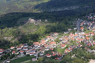
Flossenbürg is a municipality in the district of Neustadt an der Waldnaab in Bavaria in Germany. The state-approved leisure area is located in the Bavarian Forest and borders Bohemia in the east. During World War II, the Flossenbürg concentration camp was located here.

Hirschau is a municipality in the Amberg-Sulzbach district, Upper Palatinate, Bavaria, Germany.

Bayerisch Eisenstein, until 1951 just Eisenstein is a village and a municipality in the Regen district, in Bavaria, Germany.

Roding is a town in the district of Cham, in Bavaria, Germany, near the Czech border.

Georgenberg is a municipality in the district of Neustadt an der Waldnaab in Bavaria in Germany, on the border with the Czech Republic.

Schönsee is a town in the district of Schwandorf, in Bavaria, Germany. It is situated near the border with the Czech Republic, 38 km northeast of Schwandorf, and 34 km southeast of Weiden in der Oberpfalz.

Kümmersbruck is a municipality in the Amberg-Sulzbach district, in the state of Bavaria, Germany. It is situated 3 km southeast of Amberg. A division of the German Military is stationed here. Kümmersbruck is split up in 7 districts: Kümmersbruck, Haselmühl, Gärmersdorf, Moos, Haidweiher, Penkhof, Lengenfeld and Engelsdorf. The river Vils crosses the municipality.

Freyung is a town in Bavaria, Germany, capital of the Freyung-Grafenau district. It is situated in the Bavarian Forest mountain range, near the border with Austria and the Czech Republic.

Furth im Wald is a town in Bavaria, Germany, near the Czech border in the Bavarian Forest, 16 kilometres northeast of Cham, and 17 kilometres southwest of Domažlice. The city is known as Drachenstadt, a reference to Furth im Wald's annual Drachenstich play. The Drachenstich, originally part of a Corpus Christi procession, was first mentioned in 1590. As one of the oldest folk plays in the German language, each year actors re-enact the legend of Saint George slaying the dragon. In 2010, the play became notable for using the world's largest walking robot, an animatronic dragon called Tradinno.

Pfreimd is a town in the district of Schwandorf, in Bavaria, Germany. It is situated on the river Naab, 19 km north of Schwandorf, and 20 km south of Weiden in der Oberpfalz. It is also close to the border with the Czech Republic.

Pleystein is a municipality in the district of Neustadt an der Waldnaab, in Bavaria, Germany. It is situated 18 km east of Weiden in der Oberpfalz, and 11 km west of Rozvadov.

Schönwald is a town in the district of Wunsiedel, in Bavaria, Germany. It is situated near the border with the Czech Republic, five km northwest of Selb and 18 km southeast of Hof.

Waldmünchen, Czech: Lesní Mnichov, is a town in the district of Cham, in Bavaria, Germany. It is situated near the border with the Czech Republic, 18 km (11 mi) north of Cham, and 18 km (11 mi) southwest of Domažlice.

Eschlkam is a municipality in the district of Cham in Bavaria in Germany.
Haidmühle is a municipality in the district of Freyung-Grafenau in Bavaria in Germany.

Philippsreut is a municipality in the district of Freyung-Grafenau in Bavaria, Germany. It lies on the border with the Czech Republic.

Aschheim is a small town and municipality in the district of Munich in Bavaria in Germany. It lies beyond the northeastern outskirts of Munich.

Eslarn is a market town and municipality in the district of Neustadt an der Waldnaab in Bavaria in Germany.
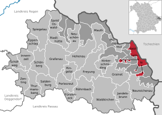
Breitenberg is a municipality in the district of Passau in Bavaria in Germany. It lies on the border with Austria, and is the easternmost municipality of Bavaria.

Salzweg is a municipality in the district of Passau in Bavaria in Germany. It is located near the German border with Austria.


