Parkstein

Last updated
Parkstein
Wappen Parkstein.png
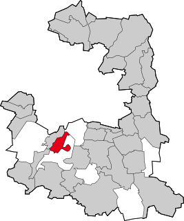
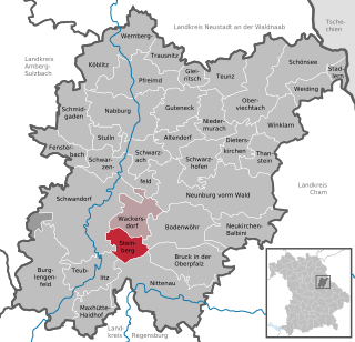
Location of Parkstein within Neustadt a.d.Waldnaab district
Parkstein in NEW.svg
Germany adm location map.svg
Red pog.svg
Parkstein
Bavaria location map.svg
Red pog.svg
Parkstein
Coordinates: 49°43′N12°4′E / 49.717°N 12.067°E / 49.717; 12.067 Coordinates: 49°43′N12°4′E / 49.717°N 12.067°E / 49.717; 12.067
Country Germany
State Bavaria
Admin. region Oberpfalz
District Neustadt a.d.Waldnaab
Municipal assoc. Neustadt an der Waldnaab
Subdivisions13 Ortsteile
Government
   Mayor (202026) Reinhard Sollfrank [1]
Area
  Total27.17 km2 (10.49 sq mi)
Elevation
547 m (1,795 ft)
Population
 (2020-12-31) [2]
  Total2,331
  Density86/km2 (220/sq mi)
Time zone UTC+01:00 (CET)
  Summer (DST) UTC+02:00 (CEST)
Postal codes
92711
Dialling codes 09602
Vehicle registration NEW
Website www.parkstein.de

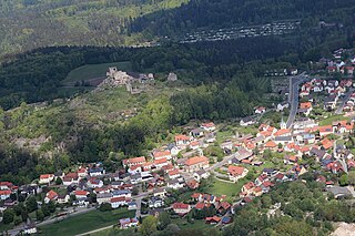
Parkstein (Northern Bavarian: Parkstoa) is a municipality in the district of Neustadt an der Waldnaab in Bavaria in Germany. In 2020, it counted approximately 2,300 inhabitants. The origins of its castle, built atop a conical shaped mountain, also called the Parkstein, date back to around the year 1000. A first written account of its existence can be traced back to the year 1053 in the documentations of the monks of Niederalteich of the Reichstag in Merseburg. Parkstein was chartered in 1435. [3]

Most likely in November 1796, Alexander von Humboldt called the 24-million-year-old basalt formation the most beautiful he had encountered in Europe. According to the Bavarian State Geology Office, during the Cenozoic, from Paleocene to the Pliocene epochs, a number of active volcanoes produced liquid magma in Northern Bavaria, mostly due to the continental collision of Europe and Africa. As a result, not only the Alps but a number of fissures and cracks began to form throughout central Europe where magma could rise. Most of the Parkstein's magma cooled below the surface, leading to the crystalline column formation that is now exposed as a result of erosion.

Related Research Articles

Flossenbürg, Bavaria Municipality in Bavaria, Germany

Flossenbürg is a municipality in the district of Neustadt an der Waldnaab in Bavaria in Germany. The state-approved leisure area is located in the Bavarian Forest and borders Bohemia in the east. During World War II, the Flossenbürg concentration camp was located here.

Pfaffenhofen an der Ilm Town in Bavaria, Germany

Pfaffenhofen an der Ilm is a municipality in Bavaria, Germany, capital of the district Pfaffenhofen. It is located on the river Ilm, and had a population of 23,282 in 2004.

Ostheim Town in Bavaria, Germany

Ostheim vor der Rhön is a town in Northern Bavaria in the district of Rhön-Grabfeld in Franconia. Though politically part of Bavaria since 1947, it was historically a part of Thuringia, and remains religiously, architecturally, and to some extent culturally distinct from its immediate surroundings.

Lauf an der Pegnitz Town in Bavaria, Germany

Lauf an der Pegnitz is a town to the East of Nuremberg, Germany. It is the capital of the district Nürnberger Land, in Bavaria. It is in the valley of the River Pegnitz, which flows through the town.

Tirschenreuth Town in Bavaria, Germany

Tirschenreuth is the capital city of the district of Tirschenreuth. It is located in the northeast of Bavaria, very close to the Czech-Bavarian border.

Ergolding Municipality in Bavaria, Germany

Ergolding is a municipality in the district of Landshut, in Bavaria, Germany. It is situated on the left bank of the Isar, 5 km northeast of Landshut.

Grünwald, Bavaria Municipality in Bavaria, Germany

Grünwald is a municipality in the district of Munich, in the state of Bavaria, Germany. It is located on the right bank of the Isar, 12 km southwest of Munich (centre). As of 31 December 2011 it had a population of 11,109.

Feldkirchen-Westerham Municipality in Bavaria, Germany

Feldkirchen-Westerham is a municipality in the district of Rosenheim, in Bavaria, Germany. It is situated 22 km west of Rosenheim.

Freystadt Town in Bavaria, Germany

Freystadt is a town in the district of Neumarkt in Bavaria. It is situated near the Rhine-Main-Danube Canal, 14 km southwest of Neumarkt in der Oberpfalz, and 33 km southeast of Nuremberg.

Mitterteich Town in Bavaria, Germany

Mitterteich is a municipality in the district of Tirschenreuth, in Bavaria, Germany. It is situated 10 km northwest of Tirschenreuth, and 17 km southwest of Cheb.

Lalling Municipality in Bavaria, Germany

Lalling is a municipality in the Lower Bavarian district of Deggendorf in Germany. It is a nationally recognized resort town.

Spiegelau Municipality in Bavaria, Germany

Spiegelau is a municipality in the district of Freyung-Grafenau in Bavaria in Germany. It lies in the heart of the Bavarian Forest.

Bad Steben Municipality in Bavaria, Germany

Bad Steben is a market town in the district of Hof in Bavaria in Germany. In 2007, Bad Steben celebrated its 175th anniversary as a Bavarian State Spa.

Altfraunhofen Municipality in Bavaria, Germany

Altfraunhofen is a municipality in the district of Landshut in Bavaria in Germany.

Kreuth Municipality in Bavaria, Germany

Kreuth is a municipality in the district of Miesbach in Bavaria in Germany.

Oberstaufen Municipality in Bavaria, Germany

Oberstaufen is a municipality in the district of Oberallgäu in Bavarian Swabia, Germany, situated on the B 308 road from Lindau to Immenstadt.

Westendorf (Allgäu) Municipality in Bavaria, Germany

Westendorf is a municipality in the district of Ostallgäu in Bavaria in Germany.

Schmidgaden Municipality in Bavaria, Germany

Schmidgaden is a municipality in the district of Schwandorf in Bavaria, Germany.

Giebelstadt Municipality in Bavaria, Germany

Giebelstadt is a municipality in the district of Würzburg in Bavaria in Germany.

Steinberg am See Municipality in Bavaria, Germany

Steinberg am See is a municipality in the district of Schwandorf in Bavaria, Germany.

References

  1. Liste der ersten Bürgermeister/Oberbürgermeister in kreisangehörigen Gemeinden, Bayerisches Landesamt für Statistik, 15 July 2021.
  2. "Tabellenblatt "Daten 2", Statistischer Bericht A1200C 202041 Einwohnerzahlen der Gemeinden, Kreise und Regierungsbezirke". Bayerisches Landesamt für Statistik (in German). June 2021.
  3. Columbia-Lippincott Gazetteer, p. 1432