Waikeria settlement and the prison are in two SA1 statistical areas which cover 55.80km2 (21.54sqmi).[1] The SA1 areas are part of the larger Puniu statistical area.
The SA1 areas had a population of 534 at the 2018 New Zealand census, an increase of 60 people (12.7%) since the 2013 census, and a decrease of 174 people (−24.6%) since the 2006 census. There were 84 households, comprising 435 males and 96 females, giving a sex ratio of 4.53 males per female, with 48 people (9.0%) aged under 15 years, 165 (30.9%) aged 15 to 29, 294 (55.1%) aged 30 to 64, and 21 (3.9%) aged 65 or older.
Ethnicities were 55.6% European/Pākehā, 47.2% Māori, 5.6% Pacific peoples, 2.8% Asian, and 1.1% other ethnicities. People may identify with more than one ethnicity.
Although some people chose not to answer the census's question about religious affiliation, 54.5% had no religion, 26.4% were Christian, 7.3% had Māori religious beliefs, 1.7% were Muslim, 0.6% were Buddhist and 5.1% had other religions.
Of those at least 15 years old, 30 (6.2%) people had a bachelor's or higher degree, and 72 (14.8%) people had no formal qualifications. 45 people (9.3%) earned over $70,000 compared to 17.2% nationally. The employment status of those at least 15 was that 183 (37.7%) people were employed full-time, 54 (11.1%) were part-time, and 24 (4.9%) were unemployed.[2]
Puniu statistical area
Puniu statistical area covers 674.02km2 (260.24sqmi)[1] and had an estimated population of 1,580 as of June 2023,[8] with a population density of 2.3 people per km2.
Puniu had a population of 1,488 at the 2018 New Zealand census, an increase of 81 people (5.8%) since the 2013 census, and a decrease of 12 people (−0.8%) since the 2006 census. There were 408 households, comprising 933 males and 555 females, giving a sex ratio of 1.68 males per female. The median age was 33.4 years (compared with 37.4 years nationally), with 291 people (19.6%) aged under 15 years, 366 (24.6%) aged 15 to 29, 726 (48.8%) aged 30 to 64, and 108 (7.3%) aged 65 or older.
Ethnicities were 76.2% European/Pākehā, 27.4% Māori, 2.8% Pacific peoples, 4.2% Asian, and 1.6% other ethnicities. People may identify with more than one ethnicity.
The percentage of people born overseas was 10.9, compared with 27.1% nationally.
Although some people chose not to answer the census's question about religious affiliation, 58.7% had no religion, 27.0% were Christian, 2.6% had Māori religious beliefs, 0.8% were Hindu, 0.6% were Muslim, 0.4% were Buddhist and 3.6% had other religions.
Of those at least 15 years old, 135 (11.3%) people had a bachelor's or higher degree, and 225 (18.8%) people had no formal qualifications. The median income was $28,300, compared with $31,800 nationally. 165 people (13.8%) earned over $70,000 compared to 17.2% nationally. The employment status of those at least 15 was that 642 (53.6%) people were employed full-time, 171 (14.3%) were part-time, and 42 (3.5%) were unemployed.[9]
Education
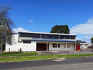
Korakonui School is a Year 1–8 co-educational state primary school.[10][11] It has a roll of 147 as of February 2024.[12][13] The school opened in 1911.[14]
Cape Runaway is the eastern extremity of the Bay of Plenty in New Zealand's North Island. It is located 157 kilometres northeast off Whakatāne and 65 kilometres west of East Cape.
Te Poi is a small village in rural Waikato, New Zealand, established in 1912 at the base of the Kaimai Range. Te Poi is part of a thriving farming area, particularly for dairying, thoroughbred horse breeding and cropping.
Matauri Bay is a bay in New Zealand, situated 30 km north of Kerikeri, in Whangaroa county, just north of the Bay of Islands. It has over a kilometre of white sand and crystal clear water, making it a popular summer destinations for surfers, divers, fishers and holidaymakers.
Reporoa is a rural community in Rotorua Lakes within the Waikato region of New Zealand's North Island.
Paterangi is a settlement in the Waikato region of New Zealand's North Island. It is located 10 km northwest of Te Awamutu. It is close to the site of one of the most strongly fortified pā built during the New Zealand wars of the late 19th century.
Pukepoto is a town in Northland, New Zealand. It lies south west of Kaitaia and north east of Ahipara. The Herekino Forest lies to the south east.
Panguru is a community in the northern Hokianga harbour, in Northland, New Zealand. The Whakarapa Stream flows from the Panguru Range in the Warawara Forest to the west, through Panguru and into the Hokianga.
Rawhiti is a small beachfront town about 27km from Russell in the Bay of Islands of New Zealand.
Karetu is a community in the Northland Region of the North Island of New Zealand. Kawakawa is to the west, and Waikare is northeast. The Karetu River flows from the Russell Forest in the southeast through Karetu, and joins the Kawakawa River shortly before it flows into the Bay of Islands.
Motatau or Mōtatau is a locality in the Northland Region of the North Island of New Zealand. Maromaku is to the east. The Taikirau Stream flows from east through Motatau and then runs northwest to join the Waiharakeke Stream. The North Auckland Line runs through Motatau.
Rawhitiroa is a locality situated in South Taranaki, New Zealand. It is positioned approximately 6.5 km east of Eltham.
Onewhero is a village and rural community in the Waikato District and Waikato region of New Zealand's North Island.
Mokai is a rural community in the Taupō District and Waikato region of New Zealand's North Island.
Te Kawa is a rural community in the Ōtorohanga District and Waikato region of New Zealand's North Island. It lies just to the south of the volcanic hills of Kakepuku and Te Kawa. Until the swamp was drained in the 1900s, Te Kawa was well known for its eels.
Rangiuru is a rural community in the Bay of Plenty of New Zealand's North Island.
Poukawa is a rural community in the Hastings District and Hawke's Bay Region of New Zealand's North Island.
Pokuru is a rural community in the Waipa District and Waikato region of New Zealand's North Island.
Oruanui is a rural community in the Taupō District and Waikato region of New Zealand's North Island, located northwest of Wairakei on State Highway 1.
Takahue is a rural community in the Far North District and Northland Region of New Zealand's North Island, south of Kaitaia.
Hexton is a village and rural area in the Gisborne District of New Zealand's North Island. It is located north-west of Gisborne City, and includes the settlements of Makauri and Waerengaahika.
This page is based on this Wikipedia article Text is available under the CC BY-SA 4.0 license; additional terms may apply. Images, videos and audio are available under their respective licenses.