Waikato is a local government region of the upper North Island of New Zealand. It covers the Waikato District, Waipa District, Matamata-Piako District, South Waikato District and Hamilton City, as well as Hauraki, Coromandel Peninsula, the northern King Country, much of the Taupō District, and parts of Rotorua District. It is governed by the Waikato Regional Council.

Matamata-Piako District is a local government area in the Waikato region of New Zealand. It lies to the east of the city of Hamilton.
Morrinsville is a provincial town in the Waikato region of New Zealand's North Island, with a population of approximately 7,000 in the 2013 Census. The town is located at the northern base of the Pakaroa Range, and on the south-western fringe of the Hauraki Plains. Morrinsville is around 33 kilometres east of Hamilton and 22 kilometres west of Te Aroha. The town is bordered by the Piako River to the east and the Waitakaruru Stream to the south.

The Waipā River is in the Waikato region of the North Island of New Zealand. The headwaters are in the Rangitoto Range east of Te Kuiti. It flows north for 115 kilometres (71 mi), passing through Ōtorohanga and Pirongia, before flowing into the Waikato River at Ngāruawāhia. It is the Waikato's largest tributary. The Waipā's main tributary is the Puniu River.

The Piako River is a lowland river system that drains into the Firth of Thames on the North Island of New Zealand. Together with the Waihou River, it is one of the two main rivers systems which drains the Hauraki Plains. It is the dominant river system in the Matamata-Piako District, and on its journey it passes through the towns of Morrinsville and Ngatea.

The Hauraki Plains are a geographical feature and non-administrative area located in the northern North Island of New Zealand, at the lower (northern) end of the Thames Valley. They are located 75 kilometres south-east of Auckland, at the foot of the Coromandel Peninsula and occupy the southern portion of a rift valley bounded on the north-west by the Hunua Ranges, to the east by the Coromandel and Kaimai ranges and the west by a series of undulating hills which separate the plains from the much larger plains of the Waikato River. Broadly, the northern and southern parts of the Hauraki Plains are administered by the Hauraki District and the Matamata-Piako District respectively.
Mangateparu is a farming service community located close to the west bank of the Piako River, eight kilometres north of Morrinsville in the Waikato region of New Zealand. It has a population of about 400 people. The local school was forced to close in 2004.
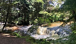
The Waitakaruru River is a river of the Waikato Region of New Zealand's North Island. It flows initially north before turning northwest across the northwestern corner of the Hauraki Plains, reaching the southwestern corner of the Firth of Thames close to the settlement of Waitakaruru.
The Whangamarino River is a lowland river of the Waikato Region of New Zealand's North Island, draining the Whangamarino Wetland and associated farmland catchment. The river converges with the Waikato River just north of Meremere. The main tributary is the Maramarua River, which starts in the Hunua Ranges and forms the northern catchment of the Whangamarino River.
The Awaroa River is a short river in the Waikato District of New Zealand's North Island. It flows east from its source in the dunes near Karioitahi Beach and Lake Puketi, then south from Waiuku joining with the Aka Aka Stream before reaching the Waikato River in its tidal reaches close to Motutieke Island.
The Mangatangi River, or Mangatangi Stream, originates on the eastern slopes of the Hunua Ranges in New Zealand and flows roughly southwards until it is joined by the Ruaotehuia Stream just north of State Highway 2 between Mangatawhiri and Maramarua, where it becomes the Maramarua River. Mangatangi can be translated as manga tangi to stream of weeping, or as rippling stream, or babbling brook.

Tauwhare is a small rural community in the Waikato District on the outskirts of Hamilton. The Waitakaruru Arboretum and Sculpture Park is located here.

Whitikahu is a settlement scattered along Whitikahu Rd in the Waikato District and Waikato region of New Zealand's North Island.

Hapuakohe Range of hills is aligned north-south, between the Waikato River and the Hauraki Plains in the Waikato region of New Zealand. It is separated from the Taupiri Range by an air-gap at Mangawara, where the Waikato flowed about 20,000 years ago.
Glen Murray is a rural community in the Waikato District and Waikato region of New Zealand's North Island, on Highway 22, about 6 km (3.7 mi) up the Tikotiko Stream from Lake Whangape. In 2013 the population of meshblock 0846601, which includes Glen Murray, was 42. It has a garage and a War Memorial Hall, which opened in 1952. It is named after William Murray, who moved from Piako in 1885.
Tatuanui is a settlement and rural community in the Matamata-Piako District and Waikato region of New Zealand's North Island.
Kiwitahi is a rural community in the Matamata-Piako District and Waikato region of New Zealand's North Island, located directly south of Morrinsville.
Ngarua is a rural community in the Matamata-Piako District and Waikato region of New Zealand's North Island.

Eureka is a rural settlement in the Waikato District and Waikato region of New Zealand's North Island. It is located on State Highway 26, and is surrounded by dairy farmland on a flat plain.

Motumaoho is a small village in the Waikato region of New Zealand's North Island, just to the west of the Pakaroa Range. It is on SH26, 25 km (16 mi) east of Hamilton and 7 km (4.3 mi) west of Morrinsville. The village is bordered by the Waitakaruru Stream to the east. Motumaoho can be translated as an intruding clump of trees.