Te Miro

Last updated

Te Miro
Village
Te Miro Hall2.jpg
Te Miro Settlers Hall
New Zealand (location map).svg
Disc Plain red.svg
Te Miro
Coordinates: 37°48′27″S175°32′44″E / 37.80750°S 175.54556°E / -37.80750; 175.54556
Country New Zealand
Region Waikato
Territorial authority Waipa District
Area
  Total27 km2 (10 sq mi)
Population
 (June 2023) [1]
  Total500
  Density19/km2 (48/sq mi)
Postcode
3496
Te Miro welcome sign Te Miro sign.jpg
Te Miro welcome sign

Te Miro is an area in the Waipa District of the Waikato Region of the North Island of New Zealand. Te Miro is situated 31 kilometres east southeast of Hamilton, and 24 kilometres northeast of Cambridge. Te Miro has a population of approximately 500.

Contents

History

The name Te Miro for the area first became used in 1916, when it was surveyed [2] and developed for European settlement. Translations of the Maori word miro are a twist, or alternatively a torrent of water, which may have originated from the many streams that twist through the hills of the area. [3] Prior to that, the area was known as Maungakawa. [4] The first Maori settlement in the Te Miro area was by the Ngāti Hauā people at Te Kawehitiki (37 49 20; 175 34 50), located on the lower reaches of the Maungakawa volcanic cone, which is on the present day Hopehill farm, [5] at 789 Te Miro Road. There is a history of large Maori gatherings beginning at the site in the 1880s, [6] [7] with a notable large gathering in 1893. [8] Maungakawa became a focal point for the Waikato King movement led by King Tawhiao. A Maori Parliament meeting house was established at the pā site in 1891, [9] but was only used for large formal meetings a few times. The structure was badly damaged by fire in 1898. The damaged structure was still physically present but abandoned in 1902 [10] before it was dismantled shortly after. Original access from Cambridge to the Maungakawa pā area before 1920 was by Maungakawa Road up what is now known as Sanatorium Hill.

The arrival of the first missionaries in New Zealand in 1814 eventually led to European settlers arriving in the Waikato. [11] In the 1850s missionaries and farmers from Britain settled in the Te Miro area and introduced modern farming practices to local Maori, helping them set up two flour mills and importing grinding wheels from England and France. During this time, wheat was a profitable crop, but when merchants in Auckland began purchasing cheaper grain from Australia the market went into decline. In 1868, Daniel Thornton was the first settler to buy land near Te Miro, [11] and around 1894, his widow established a large residence at what is now known as Sanatorium Hill.

In 1916, the government purchased [12] most of the 12,000 acre farm of James Taylor, which was surveyed, named the Te Miro Settlement, [13] and opened up to settlement after the First World War. 72 newly surveyed sections, ranging in size from 1 to 323 acres, were balloted to returning servicemen. The new settlement initially used Maungakawa Road (south of the village and formerly called Taylor Road) to access Cambridge via Sanitorium Hill, but eventually Te Miro Road (west of the village, and formerly known as Valley Road) was linked at the bottom of the hill to Flume Road, and that route has now become the main access road. The focal village of Te Miro (37 48 35; 175 32 50) township was surveyed at the intersection of present day Te Miro and upper Maungakawa roads, with an initial 20 small lots and a designated school reserve site. A school was built on the designated school reserve in 1920, and a post office started operating out of a back room in a local residence in 1921. The first industry was a Rimu sawmill, located in the bush above the school, which was supported by a bush tramway. A community hall was built in 1956. [14] Much of the original balloted farmland required scrub clearing, and for the new settlers, there was little financial support from the government for the settlers. [11] A plague of rabbits, and the depression of 1921 caused many of the initial soldier-settlers to abandon their allotments. However, some persisted, and established farms which have survived and prospered, and passed down through the generations.

In 2020, Te Miro celebrated its centennial, and a history [15] of the school and district was published. It is presently a community of approximately 280 properties, made up of several dozen dairy and drystock farms over 50 acres in size, around 40 lifestyle blocks of between 2 and 50 acres, and the balance residences on less than 2 acres. [16]

Geography

The area shown as Te Miro when retrieved from Google maps at present includes a southern lobe that is usually referred to locally as Whitehall. The remainder, excluding the Whitehall lobe and locally referred to as Te Miro, is about 27 square kilometres in size, approximately the same area as nearby Cambridge. The population of Te Miro is approximately 500 persons. The most visible point in the Te Miro district is the extinct volcanic cone known as Ruru (37 47 45; 175 34 50), which is 482 metres high. A 59-metre telecommunications tower is situated on the top of Ruru. [17] From Ruru, two other extinct volcanic cones, Maungakawa (496 metres) (37 48 50; 175 36 40), and Te Tapui (495 metres) (37 50 30; 175 34 50) extend in a south easterly direction for approximately 10 kilometres. The contour of the district is gently rolling hills, from 40 to 496 metres above sea level. Land use is mainly pastoral and dairy farming, some areas of native bush and reserves, and some small blocks of Radiata pine forestry plantations. There is negligible industrial or commercial land use.

Geology

There are three main rock types in the Te Miro area, which are Greywacke (sediments deposited on the ocean floor about 140 million years ago); Andesite (lava flow from volcanic cones such as Mt Ruru, which erupted 6.2 million years ago); and Ignimbrite (consolidated volcanic ash from the Mangakino caldera complex, from about 1 million years ago). The soil on top of the rock is largely yellow brown earth, a clay rich soil with coverings of volcanic ash. The bush regions are rich in fertile black loam. [5]

Governance

Te Miro is administered by the Waipa District Council, [18] which has its seat at Te Awamutu. Te Miro is part of the Taupō general parliamentary electorate and the Hauraki-Waikato Māori electorate.

Economy

Te Miro's main sources of local employment and income today come from dairy and drystock farming. Most other residents commute to jobs in Cambridge and Hamilton.

Transport

The main access to Te Miro is from Te Miro Road, which provides access through Cambridge to the Waikato Expressway, a 4 lane motorway to Auckland. State Highway 1 south of Cambridge connects to Tauranga, Rotorua and Taupō in the southeast. Hamilton Airport, 25 minutes drive from Te Miro, is the nearest airport and provides daily flights to all New Zealand's main centres. Auckland International Airport is about a 2-hour drive from Te Miro.

Media

Cambridge has two local newspapers, the Cambridge News [19] and the Cambridge Edition. [20] There is a Facebook page that is used to share and request information and resources. [21]

Sport

Te Miro is the home of the Te Miro Mountain Bike Park [22] which provides 7 kilometres of mountain bike and jogging trails of various levels of difficulty.

Education

Te Miro School Te Miro School.jpg
Te Miro School

Te Miro School is a co-educational state primary school located in Te Miro Village. [23] [24]

The school was built in 1920. [25] It currently has three classes: a junior class (years 0–2 named "Rata"), an intermediate class (years 3-4 named "Kowhai") and a senior class (years 5–8 named "Rimu"). The combined roll is 49 as of February 2024. [26]

Two secondary schools are located in Cambridge, serviced by school buses from Te Miro.

The University of Waikato and Wintec are major tertiary institutions in nearby Hamilton.

Notable residents

Past or present residents include:

Related Research Articles

<span class="mw-page-title-main">Waikato</span> Region of New Zealand

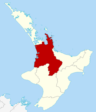
Waikato is a region of the upper North Island of New Zealand. It covers the Waikato District, Waipa District, Matamata-Piako District, South Waikato District and Hamilton City, as well as Hauraki, Coromandel Peninsula, the northern King Country, much of the Taupō District, and parts of the Rotorua Lakes District. It is governed by the Waikato Regional Council.

<span class="mw-page-title-main">Ngāruawāhia</span> Town in Waikato, New Zealand

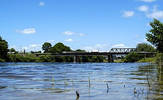
Ngāruawāhia is a town in the Waikato region of the North Island of New Zealand. It is located 20 kilometres (12 mi) north-west of Hamilton at the confluence of the Waikato and Waipā Rivers, adjacent to the Hakarimata Range. Ngāruawāhia is in the Hamilton Urban Area, the fourth largest urban area in New Zealand. The location was once considered as a potential capital of New Zealand.

<span class="mw-page-title-main">Te Awamutu</span> Town in Waikato, New Zealand

Te Awamutu is a town in the Waikato region in the North Island of New Zealand. It is the council seat of the Waipa District and serves as a service town for the farming communities which surround it. Te Awamutu is located some 30 kilometres (19 mi) south of Hamilton on State Highway 3, one of the two main routes south from Auckland and Hamilton.

<span class="mw-page-title-main">Waipā River</span> River in New Zealand

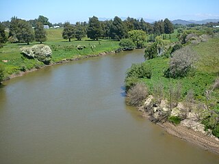
The Waipā River is in the Waikato region of the North Island of New Zealand. The headwaters are in the Rangitoto Range east of Te Kūiti. It flows north for 115 kilometres (71 mi), passing through Ōtorohanga and Pirongia, before flowing into the Waikato River at Ngāruawāhia. It is the Waikato's largest tributary. The Waipā's main tributary is the Puniu River.

<span class="mw-page-title-main">Waikato District</span> Territorial authority district in Waikato, New Zealand

Waikato District is a territorial authority of New Zealand, in the northern part of Waikato region, North Island. Waikato District is administered by the Waikato District Council, with headquarters in Ngāruawāhia.

<span class="mw-page-title-main">Waipā District</span> Territorial authority district in Waikato, New Zealand

Waipa District is a municipality in the Waikato region of New Zealand that is administered by the Waipa District Council. Its most populous town is Cambridge. The seat of the council is at the second most populous town, Te Awamutu. The district is south and south-east of the city of Hamilton. It has five wards: Te Awamutu, Cambridge, Pirongia, Maungatautari and Kakepuku.

<span class="mw-page-title-main">Kawhia Harbour</span> Harbour and settlement in Waikato, New Zealand

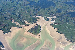
Kawhia Harbour is one of three large natural inlets in the Tasman Sea coast of the Waikato region of New Zealand's North Island. It is located to the south of Raglan Harbour, Ruapuke and Aotea Harbour, 40 kilometres southwest of Hamilton. Kawhia is part of the Ōtorohanga District and is in the King Country. It has a high-tide area of 68 km2 (26 sq mi) and a low-tide area of 18 km2 (6.9 sq mi). Te Motu Island is located in the harbour.

<span class="mw-page-title-main">Putāruru</span> Town in Waikato, New Zealand

Putāruru is a small town in the South Waikato District and the Waikato region of New Zealand's North Island. It lies on the western side of the Mamaku Ranges and in the upper basin of the Waihou River. It is on the Oraka Stream 65 kilometres south-east of Hamilton. State Highway 1 and the Kinleith Branch railway run through the town.

<span class="mw-page-title-main">Mount Pirongia</span> Extinct volcano in Waikato district of New Zealand

Mount Pirongia is an extinct stratovolcano located in the Waikato region of New Zealand's North Island. It rises to 959 m (3,146 ft) and is the highest peak around the Waikato plains. Pirongia's many peaks are basaltic cones created by successive volcanic eruptions between the late Pliocene and early Pleistocene, about 2.5 million years ago. In the adjacent picture, the characteristic profile of the mountain can be seen, along with a prominent accessory cone to the right.

<span class="mw-page-title-main">Flagstaff, Hamilton</span> Suburb of Hamilton, New Zealand

Flagstaff is a suburb in north-east Hamilton, New Zealand. It was originally called Dulverton on council plans, but it was officially named Flagstaff in 1986 when it was declared as a suburb. The area was heavily developed in the 1990s.

<span class="mw-page-title-main">Te Pahu</span> Settlement in Waikato, New Zealand

Te Pahu is a rural community in the Waipa District and Waikato region of New Zealand's North Island, located just north of Cambridge across State Highway 1.

<span class="mw-page-title-main">Maungakawa</span>

Maungakawa is located in the Waipa District, in the present day Te Miro settlement, northeast of the town of Cambridge, New Zealand. It was once the meeting place of the Kauhanganui, the parliament of the Kīngitanga and Waikato Tainui government. During the 1860s it had a population of several hundred. King Tawhiao opened a parliament building in 1891.

<span class="mw-page-title-main">Hamilton City Council (New Zealand)</span>

Hamilton City Council is the territorial authority for the New Zealand city of Hamilton.

<span class="mw-page-title-main">Whatawhata</span> Town in Waikato, New Zealand

Whatawhata, previously also spelt Whata Whata, is a small town in the Waikato region on the east bank of the Waipā River, at the junction of State Highways 23 and 39, 12 km (7.5 mi) from Hamilton. Te Araroa tramping route passes through Whatawhata.

<span class="mw-page-title-main">Te Kawa</span> Settlement in Waikato, New Zealand

Te Kawa is a rural community in the Ōtorohanga District and Waikato region of New Zealand's North Island. It lies just to the south of the volcanic hills of Kakepuku and Te Kawa. Until the swamp was drained in the 1900s, Te Kawa was well known for its eels.

<span class="mw-page-title-main">Rangiaowhia</span> Former Village in Waikato region, New Zealand

Rangiaowhia was, for over 20 years, a thriving village on a ridge between two streams in the Waikato region, about 4 km (2.5 mi) east of Te Awamutu. From 1841 it was the site of a very productive Māori mission station until the Invasion of the Waikato in 1864. The station served Ngāti Hinetu and Ngāti Apakura. Only a church remains from those days, the second oldest Waikato building.

Horotiu is a small township on the west bank of the Waikato River in the Waikato District of New Zealand. It is on the Waikato Plains 13 km (8.1 mi) north of Hamilton and 5 km (3.1 mi) south of Ngāruawāhia. From early in the 20th century it developed around a freezing works and other industries.

Glen Murray is a rural community in the Waikato District and Waikato region of New Zealand's North Island, on Highway 22, about 6 km (3.7 mi) up the Tikotiko Stream from Lake Whangape. In 2013 the population of meshblock 0846601, which includes Glen Murray, was 42. It has a garage and a War Memorial Hall, which opened in 1952. It is named after William Murray, who moved from Piako in 1885.

Hauturu is a village near the eastern shores of the Kawhia Harbour, in the Otorohanga District and Waikato region of New Zealand's North Island.

<span class="mw-page-title-main">Te Rore</span> Locality in Waikato region, New Zealand

Te Rore was in the 1850s an important transhipment point on New Zealand's Waipā River, between the agriculture of the Waikato basin and its Auckland market. That was ended in 1864 by the Invasion of the Waikato, when Te Rore was, for a few months, part of the supply route to four redoubts set up nearby. It is now a rural community in the Waipa District, 6 km (3.7 mi) north of Pirongia and roughly the same distance south of Ngāhinapōuri on State Highway 39.

References

  1. "Subnational population estimates (RC, SA2), by age and sex, at 30 June 1996-2023 (2023 boundaries)". Statistics New Zealand . Retrieved 25 October 2023. (regional councils); "Subnational population estimates (TA, SA2), by age and sex, at 30 June 1996-2023 (2023 boundaries)". Statistics New Zealand . Retrieved 25 October 2023. (territorial authorities); "Subnational population estimates (urban rural), by age and sex, at 30 June 1996-2023 (2023 boundaries)". Statistics New Zealand . Retrieved 25 October 2023. (urban areas)
  2. Te Miro Settlement, Survey map, Auckland Land District No. 1331
  3. Williams, H.W. (1975). A Dictionary of the Maori Language. Page 203
  4. One translation of Maungakawa is bitter mountain, but another is a place of formal ceremonies. Williams, H.W. (1975). A Dictionary of the Maori Language. Page 109
  5. 1 2 Hewitt, Joslyn (1995). Te Miro a history book to commemorate the 75th school and district reunion 1975. Te Miro.
  6. Waikato Times, Volume XXVI, Issue 2127, 25 February 1886, retrieved from https://paperspast.natlib.govt.nz/newspapers on 15 February 2020
  7. New Zealand Herald, Volume XXVI, Issue 9536, 30 November 1889, retrieved from https://paperspast.natlib.govt.nz/newspapers on 15 February 2020
  8. Waikato Independent, Volume XLI, Issue 3866, 16 June 1941, retrieved from https://paperspast.natlib.govt.nz/newspapers on 15 February 2020
  9. The Oxford handbook of wetland archaeology. Edited by Francesco Menotti, Aidan O’Sullivan. Pages 207–208
  10. New Zealand Herald Volume XXXIX, Issue 12046, 16 August 1902, retrieved from https://paperspast.natlib.govt.nz/newspapers on 15 February 2020
  11. 1 2 3 Parker, Sally K. (1986). Cambridge An illustrated history 1886–1986, p. 4. Cambridge Borough Council, Cambridge New Zealand. ISBN   0473003341.
  12. Parker, Eris. (2003). World War One Te Miro soldier settlement. Note on the Cambridge Museum website. Retrieved 1 February 2020.
  13. It is unclear whether the settlement was named for the Miro trees which grew in the area, or possibly from the meaning of the Maori word miro which has twisted thread and whirling current of water (for the streams in the area) as two of its meanings. Williams, H.W. (1975). A Dictionary of the Maori Language. Page 203
  14. Waipa District Council (2008). Waipa heritage trail. Page 18. ISBN   978-0-473-14254-4. Retrieved 1 February 2020.
  15. Pierce, N.J. (2020). "Te Miro School & District Centenary, 1920-2020" . Retrieved 3 September 2022.
  16. Te Miro Community Phone Book 2019
  17. New tower delivers clearer radio for Waikato audiences. 9 December 2019 Waikato Times/Stuff. Retrieved 17 January 2020.
  18. Waipa District Council
  19. "Local News and Sports - Cambridge News". www.cambridgenews.nz. Retrieved 17 April 2018.
  20. "Community Newspapers".
  21. "The Te Miro NZ Grapevine - Info Sharing Group". www.facebook.com. Retrieved 26 July 2024.
  22. Te Miro Mountain Bike Club, Retrieved 1 February 2020
  23. "Te Miro School Website".
  24. "Ministry of Education School Profile". educationcounts.govt.nz. Ministry of Education.
  25. Te Miro Jubilee Committee (1970). 1920–1970 Te Miro school and district jubilee 11 & 12 April Te Miro, NZ Te Miro Jubilee Committee
  26. "Education Review Office Report". ero.govt.nz. Education Review Office.