Tokanui, Waikato

Last updated

Tokanui
Village
Tokanui1-1834.jpg
Tokanui Hospital in the centre left, Tokanui Settlement in the foreground and Mount Kakepuku in the background
Tokanui, Waikato
Coordinates: 38°03′47″S175°19′55″E / 38.063°S 175.332°E / -38.063; 175.332 Coordinates: 38°03′47″S175°19′55″E / 38.063°S 175.332°E / -38.063; 175.332
CountryNew Zealand
Region Waikato
District Waipa District
WardKakepuku Ward
CommunityTe Awamutu Community
Government
  Territorial Authority Waipa District Council
  Regional council Waikato Regional Council
Area
[1]
  Territorial7.90 km2 (3.05 sq mi)
Population
 (2018 Census) [2]
  Territorial144
  Density18/km2 (47/sq mi)
Time zone UTC+12 (NZST)
  Summer (DST) UTC+13 (NZDT)

Tokanui is a rural locality in the Waipa District and Waikato region of New Zealand's North Island.

Contents

It is located southwest of Te Awamutu. State Highway 3 runs to the east of the locality.

History

Te Mawhai railway station operated from 1887 to 1962, originally as Te Puhi railway station. [3]

Tokanui is the site of the former Tokanui Psychiatric Hospital, which operated from 1912 to 1997. [4] The closure of the hospital resulted in the loss of 600 jobs, and there was little alternative employment available in the area. [5]

Tokanui Crossroads Hall

The hall, at 4 Te Kawa Road, [6] about 4 km (2.5 mi) south of Tokanui, [7] opened on 18 January 1928. [8] It is a converted casein factory, [9] which had been working since at least 1919. [10]

Demographics

Tokanui settlement is in an SA1 statistical area which covers 7.90 km2 (3.05 sq mi). [1] The SA1 area is part of the larger Tokanui statistical area.

Historical population of Tokanui settlement and surrounds
YearPop.±% p.a.
2006153    
2013162+0.82%
2018144−2.33%
Source: [2]

The SA1 area had a population of 144 at the 2018 New Zealand census, a decrease of 18 people (−11.1%) since the 2013 census, and a decrease of 9 people (−5.9%) since the 2006 census. There were 48 households, comprising 75 males and 69 females, giving a sex ratio of 1.09 males per female. The median age was 26.5 years (compared with 37.4 years nationally), with 39 people (27.1%) aged under 15 years, 36 (25.0%) aged 15 to 29, 57 (39.6%) aged 30 to 64, and 12 (8.3%) aged 65 or older.

Ethnicities were 66.7% European/Pākehā and 54.2% Māori. People may identify with more than one ethnicity.

Although some people chose not to answer the census's question about religious affiliation, 56.2% had no religion, 25.0% were Christian, 2.1% had Māori religious beliefs and 2.1% had other religions.

Of those at least 15 years old, 9 (8.6%) people had a bachelor's or higher degree, and 27 (25.7%) people had no formal qualifications. The median income was $26,500, compared with $31,800 nationally. 12 people (11.4%) earned over $70,000 compared to 17.2% nationally. The employment status of those at least 15 was that 54 (51.4%) people were employed full-time, 12 (11.4%) were part-time, and 9 (8.6%) were unemployed. [2]

Tokanui statistical area

Tokanui statistical area covers 23.70 km2 (9.15 sq mi) [1] and had an estimated population of 480 as of June 2022, [11] with a population density of 20 people per km2.

Historical population of the statistical area
YearPop.±% p.a.
2006426    
2013441+0.50%
2018435−0.27%
Source: [12]

The statistical area had a population of 435 at the 2018 New Zealand census, a decrease of 6 people (−1.4%) since the 2013 census, and an increase of 9 people (2.1%) since the 2006 census. There were 144 households, comprising 231 males and 207 females, giving a sex ratio of 1.12 males per female. The median age was 31.6 years (compared with 37.4 years nationally), with 105 people (24.1%) aged under 15 years, 102 (23.4%) aged 15 to 29, 195 (44.8%) aged 30 to 64, and 33 (7.6%) aged 65 or older.

Ethnicities were 66.2% European/Pākehā, 54.5% Māori, 2.8% Pacific peoples, 3.4% Asian, and 1.4% other ethnicities. People may identify with more than one ethnicity.

The percentage of people born overseas was 11.0, compared with 27.1% nationally.

Although some people chose not to answer the census's question about religious affiliation, 51.7% had no religion, 28.3% were Christian, 7.6% had Māori religious beliefs, 0.7% were Hindu and 2.1% had other religions.

Of those at least 15 years old, 33 (10.0%) people had a bachelor's or higher degree, and 81 (24.5%) people had no formal qualifications. The median income was $28,700, compared with $31,800 nationally. 45 people (13.6%) earned over $70,000 compared to 17.2% nationally. The employment status of those at least 15 was that 165 (50.0%) people were employed full-time, 54 (16.4%) were part-time, and 21 (6.4%) were unemployed. [12]

Tokanui hill

Tokanui hill is 165 m (541 ft) high [7] and an extinct arc basalt Alexandra Volcanic Group volcano. [13] It rises about 30 m (98 ft) from the surrounding hills, formed of Puketoka (3.1m year old pumice sandstone, including peat) and Karapiro (younger pumice sandstone of silt, sand and clay) Formations, [14] and about 100 m (330 ft) above the surrounding land and lies about 5 km (3.1 mi) south of the village, just to the west of SH3. [7] The hill has been quarried since 1925, [15] as Osterns, Te Kawa or McFalls Quarry. Argillitic greywacke, one of the Manaia Hill group of rocks, of Late Jurassic to Early Cretaceous age, is used for aggregate. There are three sites on the hill, Whiti Te Marama, Tokonui and Pukerimu, which are linked to Ngāti Whakatere and Ngāti Maniapoto. [16] [17]

See also

Related Research Articles

<span class="mw-page-title-main">Waikato</span> Region of New Zealand

Waikato is a local government region of the upper North Island of New Zealand. It covers the Waikato District, Waipa District, Matamata-Piako District, South Waikato District and Hamilton City, as well as Hauraki, Coromandel Peninsula, the northern King Country, much of the Taupō District, and parts of Rotorua District. It is governed by the Waikato Regional Council.

<span class="mw-page-title-main">Ngāruawāhia</span> Town in Waikato, New Zealand

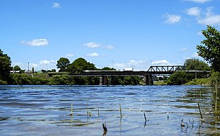
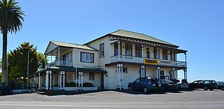
Ngāruawāhia is a town in the Waikato region of the North Island of New Zealand. It is located 20 kilometres (12 mi) north-west of Hamilton at the confluence of the Waikato and Waipā Rivers, adjacent to the Hakarimata Range. Ngāruawāhia is in the Hamilton Urban Area, the fourth largest urban area in New Zealand. The location was once considered as a potential capital of New Zealand.

<span class="mw-page-title-main">Te Awamutu</span> Town in Waikato, New Zealand

Te Awamutu is a town in the Waikato region in the North Island of New Zealand. It is the council seat of the Waipa District and serves as a service town for the farming communities which surround it. Te Awamutu is located some 30 kilometres (19 mi) south of Hamilton on State Highway 3, one of the two main routes south from Auckland and Hamilton.

<span class="mw-page-title-main">Waipā River</span> River in New Zealand

The Waipā River is in the Waikato region of the North Island of New Zealand. The headwaters are in the Rangitoto Range east of Te Kuiti. It flows north for 115 kilometres (71 mi), passing through Ōtorohanga and Pirongia, before flowing into the Waikato River at Ngāruawāhia. It is the Waikato's largest tributary. The Waipā's main tributary is the Puniu River.

<span class="mw-page-title-main">Waipa District</span> Territorial authority district in Waikato, New Zealand

Waipa District is a municipality in the Waikato region of New Zealand that is administered by the Waipa District Council. Its most populous town is Cambridge. The seat of the council is at the second most populous town, Te Awamutu. The district is south and south-east of the city of Hamilton. It has five wards: Te Awamutu, Cambridge, Pirongia, Maungatautari and Kakepuku.

<span class="mw-page-title-main">Ōtorohanga</span> Town in Waikato, New Zealand

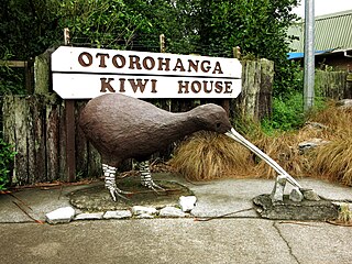
Ōtorohanga is a north King Country town in the Waikato region in the North Island of New Zealand. It is located 53 kilometres (33 mi) south of Hamilton and 18 kilometres (11 mi) north of Te Kūiti, on the Waipā River. It is a service town for the surrounding dairy-farming district. It is recognised as the "gateway" to the Waitomo Caves and as the "Kiwiana Town" of New Zealand. Until 2007, Ōtorohanga held a yearly 'Kiwiana Festival.'

<span class="mw-page-title-main">Kawhia Harbour</span> Harbour and settlement in Waikato, New Zealand

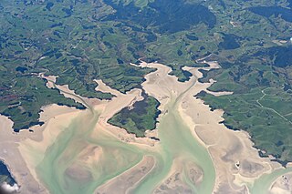
Kawhia Harbour is one of three large natural inlets in the Tasman Sea coast of the Waikato region of New Zealand's North Island. It is located to the south of Raglan Harbour, Ruapuke and Aotea Harbour, 40 kilometres southwest of Hamilton. Kawhia is part of the Ōtorohanga District and is in the King Country. It has a high-tide area of 68 km2 (26 sq mi) and a low-tide area of 18 km2 (6.9 sq mi). Te Motu Island is located in the harbour.

<span class="mw-page-title-main">Pirongia</span> Settlement in Waikato, New Zealand

Pirongia is a small town in the Waipa District of the Waikato region of New Zealand's North Island. It is 12 kilometres to the west of Te Awamutu, on the banks of the Waipā River, close to the foot of the 962 metre Mount Pirongia, which lies in Pirongia Forest Park to the west of the town.

<span class="mw-page-title-main">Flagstaff, Hamilton</span> Suburb of Hamilton, New Zealand

Flagstaff is a suburb in north-east Hamilton, New Zealand. It was originally called Dulverton on council plans, but it was officially named Flagstaff in 1986 when it was declared as a suburb. The area was heavily developed in the 1990s.

<span class="mw-page-title-main">Matatoki</span> Place in Waikato, New Zealand

Matatoki is a locality on the Hauraki Plains of New Zealand. It lies on State Highway 26, south east of Thames and north of Paeroa. The Matatoki Stream runs from the Coromandel Range through the area to join the Waihou River.

<span class="mw-page-title-main">Hinuera</span> Settlement in Waikato, New Zealand

Hinuera is a settlement in the Waikato Region of New Zealand's North Island. It is located along State Highway 29, approximately halfway between the cities of Hamilton and Tauranga. It also contains the Hinuera cliffs along State Highway 29.

<span class="mw-page-title-main">Te Pahu</span> Settlement in Waikato, New Zealand

Te Pahu is a rural community in the Waipa District and Waikato region of New Zealand's North Island, located just north of Cambridge across State Highway 1.

<span class="mw-page-title-main">Whatawhata</span> Town in Waikato, New Zealand

Whatawhata, previously also spelt Whata Whata, is a small town in the Waikato region on the east bank of the Waipā River, at the junction of State Highways 23 and 39, 12 km (7.5 mi) from Hamilton. Te Araroa tramping route passes through Whatawhata.

<span class="mw-page-title-main">Te Kawa</span> Settlement in Waikato, New Zealand

Te Kawa is a rural community in the Ōtorohanga District and Waikato region of New Zealand's North Island. It lies just to the south of the volcanic hills of Kakepuku and Te Kawa. Until the swamp was drained in the 1900s, Te Kawa was well known for its eels.

Horotiu is a small township on the west bank of the Waikato River in the Waikato District of New Zealand. It is on the Waikato Plains 13 km (8.1 mi) north of Hamilton and 5 km (3.1 mi) south of Ngāruawāhia. From early in the 20th century it developed around a freezing works and other industries.

<span class="mw-page-title-main">Whitikahu</span> Locality in Waikato, New Zealand

Whitikahu is a settlement scattered along Whitikahu Rd in the Waikato District and Waikato region of New Zealand's North Island.

Āria is a rural community in the Waitomo District and Waikato region of New Zealand's North Island.

<span class="mw-page-title-main">Ngāhinapōuri</span> Settlement in Waikato, New Zealand

Ngāhinapōuri is a rural community in the Waipa District and Waikato region of New Zealand's North Island. It is located on State Highway 39, between Whatawhata and Pirongia.

<span class="mw-page-title-main">Motumaoho</span> Village in Waikato, New Zealand

Motumaoho is a small village in the Waikato region of New Zealand's North Island, just to the west of the Pakaroa Range. It is on SH26, 25 km (16 mi) east of Hamilton and 7 km (4.3 mi) west of Morrinsville. The village is bordered by the Waitakaruru Stream to the east. Motumaoho can be translated as an intruding clump of trees.

<span class="mw-page-title-main">Te Rore</span> Locality in Waikato region, New Zealand

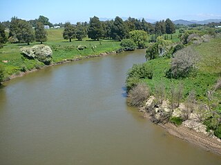
Te Rore was in the 1850s an important transhipment point on New Zealand's Waipā River, between the agriculture of the Waikato basin and its Auckland market. That was ended in 1864 by the Invasion of the Waikato, when Te Rore was, for a few months, part of the supply route to four redoubts set up nearby. It is now a rural community in the Waipa District, 6 km (3.7 mi) north of Pirongia and roughly the same distance south of Ngāhinapōuri on State Highway 39.

References

  1. 1 2 3 "ArcGIS Web Application". statsnz.maps.arcgis.com. Retrieved 31 October 2022.
  2. 1 2 3 "Statistical area 1 dataset for 2018 Census". Statistics New Zealand. March 2020. 7012940.
  3. Scoble, Juliet. "Names & Opening & Closing Dates of Railway Stations in New Zealand" (PDF). Archived from the original (PDF) on 17 January 2020.
  4. Swarbrick, Nancy (1 July 2015). "Tokanui Hospital". Te Ara: The Encyclopedia of New Zealand .
  5. Knight, David B; Joseph, Alun E (1999). "1. Social Sciences and Public Policy in Restructuring Societies". Restructuring Societies: Insights from the Social Sciences. Carleton University Press. pp. 11–13. ISBN   0-88629-344-8.
  6. "Tokanui Crossroads Hall » Ōtorohanga District Council". www.otodc.govt.nz. Retrieved 30 July 2021.
  7. 1 2 3 "Tokanui, Waikato". NZ Topo Map. Retrieved 30 July 2021.
  8. "WAIPA POST". paperspast.natlib.govt.nz. 17 January 1928. Retrieved 30 July 2021.
  9. "NEW HALL. WAIKATO TIMES". paperspast.natlib.govt.nz. 21 January 1928. Retrieved 30 July 2021.
  10. "MEETING OF THE WHAREPAPA BOARD. WAIPA POST". paperspast.natlib.govt.nz. 4 November 1919. Retrieved 30 July 2021.
  11. "Population estimate tables - NZ.Stat". Statistics New Zealand . Retrieved 25 October 2022.
  12. 1 2 "Statistical area 1 dataset for 2018 Census". Statistics New Zealand. March 2020. Tokanui (184700). 2018 Census place summary: Tokanui
  13. Edbrooke, S.W. (2005). Geology of the Waikato area. GNS. p. 34.
  14. Peter J.J. Kamp, Kirsty A. Vincent and Michael J.S. Tayler (2015). "Cenozoic sedimentary and volcanic rocks of New Zealand": 133 via School of Science, University of Waikato.{{cite journal}}: Cite journal requires |journal= (help)
  15. "TE KAWA QUARRIES, WAIKATO TIMES". paperspast.natlib.govt.nz. 19 August 1925. Retrieved 7 May 2019.
  16. "Ostern Quarries - Assessment of Effects on the Environment to support Resource Consent Applications to Waikato Regional Council and Otorohanga District Council" (PDF). 30 June 2016.
  17. "Assessment of Effects to Groundwater and Surface Water" (PDF). 29 May 2015.