Pokuru, New Zealand

Last updated

Pokuru
Village
Pokuru, New Zealand
Coordinates: 38°03′22″S175°14′07″E / 38.056049°S 175.235353°E / -38.056049; 175.235353
CountryNew Zealand
Region Waikato
District Waipa District
WardKakepuku Ward
CommunityTe Awamutu Community
Electorates
Government
  Territorial Authority Waipa District Council
  Regional council Waikato Regional Council
Area
[1]
  Territorial20.08 km2 (7.75 sq mi)
Population
 (2018 Census) [2]
  Territorial207
  Density10/km2 (27/sq mi)
Time zone UTC+12 (NZST)
  Summer (DST) UTC+13 (NZDT)

Pokuru is a rural community in the Waipa District and Waikato region of New Zealand's North Island.

Contents

It is located southwest of Te Awamutu, southeast of Pirongia and north of Ōtorohanga, between State Highway 39 and State Highway 1.

Marae

The community of Pokuru has two marae:

Demographics

Pokuru settlement is in an SA1 statistical area which covers 20.08 km2 (7.75 sq mi). [1] The SA1 area is part of the larger Pokuru statistical area.

Historical population for Pokuru and surrounds
YearPop.±% p.a.
2006171    
2013198+2.12%
2018207+0.89%
Source: [2]

The SA1 area had a population of 207 at the 2018 New Zealand census, an increase of 9 people (4.5%) since the 2013 census, and an increase of 36 people (21.1%) since the 2006 census. There were 72 households, comprising 105 males and 102 females, giving a sex ratio of 1.03 males per female. The median age was 34.3 years (compared with 37.4 years nationally), with 51 people (24.6%) aged under 15 years, 36 (17.4%) aged 15 to 29, 102 (49.3%) aged 30 to 64, and 18 (8.7%) aged 65 or older.

Ethnicities were 76.8% European/Pākehā, 11.6% Māori, 1.4% Pacific peoples, 1.4% Asian, and 15.9% other ethnicities. People may identify with more than one ethnicity.

Although some people chose not to answer the census's question about religious affiliation, 50.7% had no religion, 30.4% were Christian, 1.4% had Māori religious beliefs and 2.9% had other religions.

Of those at least 15 years old, 27 (17.3%) people had a bachelor's or higher degree, and 27 (17.3%) people had no formal qualifications. The median income was $42,900, compared with $31,800 nationally. 33 people (21.2%) earned over $70,000 compared to 17.2% nationally. The employment status of those at least 15 was that 87 (55.8%) people were employed full-time, 18 (11.5%) were part-time, and 3 (1.9%) were unemployed. [2]

Pokuru statistical area

Pokuru statistical area covers 108.79 km2 (42.00 sq mi) [1] and had an estimated population of 1,670 as of June 2023, [5] with a population density of 15 people per km2.

Historical population for the statistical area
YearPop.±% p.a.
20061,167    
20131,263+1.14%
20181,425+2.44%
Source: [6]

Before the 2023 census, the statistical area had a larger boundary, covering 109.20 km2 (42.16 sq mi). [1] Using that boundary, the statistical area had a population of 1,425 at the 2018 New Zealand census, an increase of 162 people (12.8%) since the 2013 census, and an increase of 258 people (22.1%) since the 2006 census. There were 489 households, comprising 714 males and 708 females, giving a sex ratio of 1.01 males per female. The median age was 37.7 years (compared with 37.4 years nationally), with 336 people (23.6%) aged under 15 years, 240 (16.8%) aged 15 to 29, 648 (45.5%) aged 30 to 64, and 195 (13.7%) aged 65 or older.

Ethnicities were 89.7% European/Pākehā, 12.8% Māori, 0.8% Pacific peoples, 1.9% Asian, and 4.0% other ethnicities. People may identify with more than one ethnicity.

The percentage of people born overseas was 11.8, compared with 27.1% nationally.

Although some people chose not to answer the census's question about religious affiliation, 50.9% had no religion, 37.1% were Christian, 0.6% had Māori religious beliefs, 0.2% were Hindu, 0.2% were Buddhist and 1.5% had other religions.

Of those at least 15 years old, 183 (16.8%) people had a bachelor's or higher degree, and 204 (18.7%) people had no formal qualifications. The median income was $41,200, compared with $31,800 nationally. 237 people (21.8%) earned over $70,000 compared to 17.2% nationally. The employment status of those at least 15 was that 612 (56.2%) people were employed full-time, 183 (16.8%) were part-time, and 30 (2.8%) were unemployed. [6]

Education

Pokuru School is a co-educational state primary school, [7] with a roll of 154 as of February 2024. [8] The school opened as Kakepuku School in 1907, and became Pokuru School in 1926. [9] [10]

Related Research Articles

<span class="mw-page-title-main">Waitomo</span> Settlement in Waikato, New Zealand

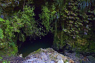
Waitomo is a rural community in the King Country region of New Zealand's North Island. There are several solutional cave systems in the area around the village, which are popular tourist attractions. Restaurants and accommodation are centred in the village to serve visiting tourists.

<span class="mw-page-title-main">Kawhia Harbour</span> Harbour and settlement in Waikato, New Zealand

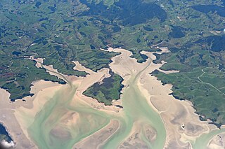
Kawhia Harbour is one of three large natural inlets in the Tasman Sea coast of the Waikato region of New Zealand's North Island. It is located to the south of Raglan Harbour, Ruapuke and Aotea Harbour, 40 kilometres southwest of Hamilton. Kawhia is part of the Ōtorohanga District and is in the King Country. It has a high-tide area of 68 km2 (26 sq mi) and a low-tide area of 18 km2 (6.9 sq mi). Te Motu Island is located in the harbour.

Taipa-Mangonui or Taipa Bay-Mangonui is a string of small resort settlements – Taipa, Cable Bay, Coopers Beach, and Mangōnui – that lie along the coast of Doubtless Bay and are so close together that they have run together to form one larger settlement.

<span class="mw-page-title-main">Te Poi</span> Settlement in Waikato, New Zealand

Te Poi is a small village in rural Waikato, New Zealand, established in 1912 at the base of the Kaimai Range. Te Poi is part of a thriving farming area, particularly for dairying, thoroughbred horse breeding and cropping.

<span class="mw-page-title-main">Matauri Bay</span> Locality in Far North District, Northland Region, New Zealand

Matauri Bay is a bay in New Zealand, situated 30 km north of Kerikeri, in Whangaroa county, just north of the Bay of Islands. It has over a kilometre of white sand and crystal clear water, making it a popular summer destinations for surfers, divers, fishers and holidaymakers.

Tautoro is a locality about 8 km south-southeast of Kaikohe in Northland, New Zealand. Further to the south is the Awarua rural community.

Pukepoto is a town in Northland, New Zealand. It lies south west of Kaitaia and north east of Ahipara. The Herekino Forest lies to the south east.

<span class="mw-page-title-main">Whangape Harbour</span> Harbor in Northland, New Zealand

Whangape Harbour is a harbour on the west coast of Northland, New Zealand. There is a settlement called Whangape on the northern side of the harbour. Another, called Pawarenga, is located on the southern side. Kaitaia is 42 km north east.

Waikare is a locality in Northland, New Zealand. The Waikare River flows from the Russell Forest past Waikare and into the Waikare Inlet, which leads into the Bay of Islands.

Panguru is a community in the northern Hokianga harbour, in Northland, New Zealand. The Whakarapa Stream flows from the Panguru Range in the Warawara Forest to the west, through Panguru and into the Hokianga.

Karetu is a community in the Northland Region of the North Island of New Zealand. Kawakawa is to the west, and Waikare is northeast. The Karetu River flows from the Russell Forest in the southeast through Karetu, and joins the Kawakawa River shortly before it flows into the Bay of Islands.

Motatau or Mōtatau is a locality in the Northland Region of the North Island of New Zealand. Maromaku is to the east. The Taikirau Stream flows from east through Motatau and then runs northwest to join the Waiharakeke Stream. The North Auckland Line runs through Motatau.

Pipiwai is a locality in the Te Horo valley in Northland, New Zealand. Whangārei is about 35 km to the southeast. Titoki is about 16 km to the south.

<span class="mw-page-title-main">Ngāti Paretekawa</span> Māori iwi in New Zealand

Ngāti Paretekawa (Paretekawa) are a very numerous hapū of the Ngāti Maniapoto confederation in New Zealand, whose ancestral tribal lands are located in both the northern King Country, including the areas around the Kakepuku, Pirongia, in the vicinity of Te Awamutu, Kihikihi, Pokuru, Kakepuku, and Kawhia, with sub-hapu interests in the southern King Country area of the Mokau and Kawhia, at the foothills of Kahuwera Mountain.

<span class="mw-page-title-main">Mokai</span> Settlement in Waikato, New Zealand

Mokai is a rural community in the Taupō District and Waikato region of New Zealand's North Island.

<span class="mw-page-title-main">Te Kawa</span> Settlement in Waikato, New Zealand

Te Kawa is a rural community in the Ōtorohanga District and Waikato region of New Zealand's North Island. It lies just to the south of the volcanic hills of Kakepuku and Te Kawa. Until the swamp was drained in the 1900s, Te Kawa was well known for its eels.

<span class="mw-page-title-main">Pirinoa</span> Rural locality in the Wellington Region, New Zealand

Pirinoa is a rural community east of Lake Wairarapa, in the South Wairarapa District and Wellington Region of New Zealand's North Island. It includes the rural settlement of Pirinoa, and the coastal settlement of Whāngaimoana.

Rangiuru is a rural community in the Bay of Plenty of New Zealand's North Island.

<span class="mw-page-title-main">Takahue</span> Rural community in New Zealand

Takahue is a rural community in the Far North District and Northland Region of New Zealand's North Island, south of Kaitaia.

Maungatautari is a rural community in Waipa District, Waikato Region, New Zealand. It is located between Maungatautari Mountain and Lake Karapiro on the Waikato River. Horohora township is to its north west. Pukeatua township is on the southern flank of the volcano overlooked by a south eastern peak called Te Akatarere.

References

  1. 1 2 3 4 "ArcGIS Web Application". statsnz.maps.arcgis.com. Retrieved 18 April 2024.
  2. 1 2 3 "Statistical area 1 dataset for 2018 Census". Statistics New Zealand. March 2020. 7012726.
  3. "Te Kāhui Māngai directory". tkm.govt.nz. Te Puni Kōkiri.
  4. "Māori Maps". maorimaps.com. Te Potiki National Trust.
  5. "Population estimate tables - NZ.Stat". Statistics New Zealand . Retrieved 25 October 2023.
  6. 1 2 "Statistical area 1 dataset for 2018 Census". Statistics New Zealand. March 2020. Pokuru (182100). 2018 Census place summary: Pokuru
  7. Education Counts: Pokuru School
  8. "Education Review Office Report". ero.govt.nz. Education Review Office.
  9. "Pokuru School". Te Awamutu Museum. Retrieved 3 November 2020.
  10. "Pokuru School and district diamond jubilee, 1907-1982 (collection record)". National Library. Retrieved 3 November 2020.