Hautapu

Last updated

Hautapu
Village
Hautapu
Coordinates: 37°51′43″S175°27′17″E / 37.861811°S 175.454812°E / -37.861811; 175.454812
CountryNew Zealand
Region Waikato
District Waipa District
Ward
  • Cambridge Ward
  • Maungatautari Ward
CommunityCambridge Community
Electorates
Government
  Territorial Authority Waipa District Council
  Regional council Waikato Regional Council
Area
[1]
  Territorial22.14 km2 (8.55 sq mi)
Population
 (June 2023) [2]
  Territorial1,380
  Density62/km2 (160/sq mi)
Time zone UTC+12 (NZST)
  Summer (DST) UTC+13 (NZDT)
Cambridge Co-operative Dairy Co, Hautapu, between 1923-1928 Cambridge Co-operative Dairy Co, Hautapu, between 1923-1928 (3057756510).jpg
Cambridge Co-operative Dairy Co, Hautapu, between 1923-1928

Hautapu is a township in the Waipa District and Waikato region of New Zealand's North Island, located just north of Cambridge across State Highway 1.

Contents

The area was identified as the Hautapu Parish on a militia farm map published in 1864 during the Waikato War, named after the Hautapu Rapids which previously occupied the site of the current Karapiro Power Station. The Hautapu Cemetery was established in June 1866. [3]

A Fonterra dairy factory is a key feature of the township. The factory was proposed in August 1884 and began processing milk on 20 December 1884 as the Cambridge Produce and Dairy Factory. In 1886, the factory was sold to new owners and was expanded to produce butter, cheese and bacon after running into problems with milk supplies. In 1901, it was sold to a new dairy co-operative which replaced the factory with a new brick factory in 1908. The factory began specialising in cheese in 1915, and came under the ownership of the new national dairy co-operative in 1919. [3] [4]

Jas Taylor was one of the first and most significant early settlers; several others followed as the area became more densely populated between the 1910s and 1930s. [5] This trend then reversed, as smaller farms consolidated into larger farms. [3] [6]

A 56.7-hectare (140-acre) industrial plant is being developed at Hautapu between 2019 and 2024, which is expected to employ 1150 jobs once completed. [7] Most of these jobs will be at a new 44m² ALP aluminium factory being constructed to replace a 1970s plant in Te Rapa, once of the largest factories ever built in New Zealand. [8]

The township has its own rugby, netball and hockey club. [9] [10] The rugby club plays in a local tournament with other local town clubs. [11] [12]

There is a Returned and Services' Association memorial in the town, listing people from Cambridge killed during the Boer War, World War I and World War II. [13] Ten World War I casualties and two World War II casualties are buried at the local cemetery. [14]

Demographics

Hautapu covers 22.14 km2 (8.55 sq mi) [1] and had an estimated population of 1,380 as of June 2023, [2] with a population density of 62 people per km2.

Historical population
YearPop.±% p.a.
2006990    
20131,206+2.86%
20181,173−0.55%
Source: [15]

Hautapu had a population of 1,173 at the 2018 New Zealand census, a decrease of 33 people (−2.7%) since the 2013 census, and an increase of 183 people (18.5%) since the 2006 census. There were 423 households, comprising 582 males and 594 females, giving a sex ratio of 0.98 males per female, with 216 people (18.4%) aged under 15 years, 243 (20.7%) aged 15 to 29, 564 (48.1%) aged 30 to 64, and 153 (13.0%) aged 65 or older.

Ethnicities were 92.6% European/Pākehā, 8.7% Māori, 2.6% Pacific peoples, 4.3% Asian, and 1.0% other ethnicities. People may identify with more than one ethnicity.

The percentage of people born overseas was 19.9, compared with 27.1% nationally.

Although some people chose not to answer the census's question about religious affiliation, 58.3% had no religion, 34.3% were Christian, 0.3% were Hindu, 0.5% were Buddhist and 0.5% had other religions.

Of those at least 15 years old, 201 (21.0%) people had a bachelor's or higher degree, and 144 (15.0%) people had no formal qualifications. 207 people (21.6%) earned over $70,000 compared to 17.2% nationally. The employment status of those at least 15 was that 543 (56.7%) people were employed full-time, 174 (18.2%) were part-time, and 30 (3.1%) were unemployed. [15]

Individual statistical areas
NameArea
(km2)
PopulationDensity
(per km2)
HouseholdsMedian ageMedian
income
Hautapu7.434746417133.8 years$34,600 [16]
Hautapu Rural14.716994825243.1 years$38,000 [17]
New Zealand37.4 years$31,800

Hautapu statistical area is within the Cambridge urban area and Hautapu Rural is outside it.

Education

Hautapu School is a co-educational state primary school for Year 1 to 8 students, [18] [19] with a roll of 182 as of February 2024. [20]

The school board was established in January 1876 and teacher Rev McLaurin began classes in March 1877. The school was relocated in 1884, and new school was built at another more central site in 1910. The school was enlarged again three times between 1918 and 1953. [3]

See also

Category:Burials at Hautapu Cemetery

Related Research Articles

<span class="mw-page-title-main">Waikato</span> Region of New Zealand

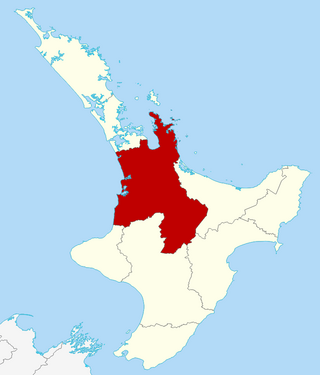
Waikato is a region of the upper North Island of New Zealand. It covers the Waikato District, Waipa District, Matamata-Piako District, South Waikato District and Hamilton City, as well as Hauraki, Coromandel Peninsula, the northern King Country, much of the Taupō District, and parts of the Rotorua Lakes District. It is governed by the Waikato Regional Council.

<span class="mw-page-title-main">Cambridge, New Zealand</span> Town in Waikato, New Zealand

Cambridge is a town in the Waipa District of the Waikato region of the North Island of New Zealand. Situated 24 kilometres (15 mi) southeast of Hamilton, on the banks of the Waikato River, Cambridge is known as "The Town of Trees & Champions". The town has a population of 21,800, making it the largest town in the Waipa District, and the third largest urban area in the Waikato.

<span class="mw-page-title-main">Ngāruawāhia</span> Town in Waikato, New Zealand

Ngāruawāhia is a town in the Waikato region of the North Island of New Zealand. It is located 20 kilometres (12 mi) north-west of Hamilton at the confluence of the Waikato and Waipā Rivers, adjacent to the Hakarimata Range. Ngāruawāhia is in the Hamilton Urban Area, the fourth largest urban area in New Zealand. The location was once considered as a potential capital of New Zealand.

<span class="mw-page-title-main">Te Awamutu</span> Town in Waikato, New Zealand

Te Awamutu is a town in the Waikato region in the North Island of New Zealand. It is the council seat of the Waipa District and serves as a service town for the farming communities which surround it. Te Awamutu is located some 30 kilometres (19 mi) south of Hamilton on State Highway 3, one of the two main routes south from Auckland and Hamilton.

<span class="mw-page-title-main">Morrinsville</span> Town in Waikato, New Zealand

Morrinsville is a provincial town in the Waikato region of New Zealand's North Island, with an estimated population of 8,960 as of June 2023. The town is located at the northern base of the Pakaroa Range, and on the south-western fringe of the Hauraki Plains. Morrinsville is around 33 kilometres east of Hamilton and 22 kilometres west of Te Aroha. The town is bordered by the Piako River to the east and the Waitakaruru Stream to the south.

Tokoroa is the fifth-largest town in the Waikato region of the North Island of New Zealand and largest settlement in the South Waikato District. Located 30 km southwest of Rotorua and 20 km south of Putāruru, close to the foot of the Mamaku Ranges, it is midway between Taupō and Hamilton on State Highway 1.

<span class="mw-page-title-main">Waipā District</span> Territorial authority district in Waikato, New Zealand

Waipa District is a municipality in the Waikato region of New Zealand that is administered by the Waipa District Council. Its most populous town is Cambridge. The seat of the council is at the second most populous town, Te Awamutu. The district is south and south-east of the city of Hamilton. It has five wards: Te Awamutu, Cambridge, Pirongia, Maungatautari and Kakepuku.

<span class="mw-page-title-main">Pirongia</span> Settlement in Waikato, New Zealand

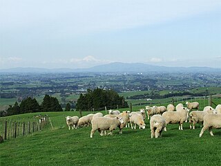
Pirongia is a small town in the Waipa District of the Waikato region of New Zealand's North Island. It is 12 kilometres to the west of Te Awamutu, on the banks of the Waipā River, close to the foot of the 962 metre Mount Pirongia, which lies in Pirongia Forest Park to the west of the town.

<span class="mw-page-title-main">Te Rapa</span> Suburb of Hamilton, New Zealand

Te Rapa is a mixed light industrial, large-scale retail and semi-rural suburb to the northwest of central Hamilton, New Zealand that is built on a flat area that was previously the bed of an ancient river, the forerunner to the present Waikato River.

<span class="mw-page-title-main">Hamilton East, New Zealand</span> Suburb of Hamilton, New Zealand

Hamilton East is a suburb in central Hamilton in New Zealand. The suburb's primary commercial and retail precinct is located along Grey Street. Hamilton East is characterised by villas and bungalows built early in the 20th century.

<span class="mw-page-title-main">Pōkeno</span> Town in Waikato, New Zealand

Pōkeno is a small town in the Waikato District of the Waikato region in New Zealand, 53 km (33 mi) southeast of Auckland, 9 km (5.6 mi) from Tuakau and 5 km (3.1 mi) from Mercer. State Highway 1 originally ran through the town, but the upgrading of the highway in 1992 to expressway standards mean that the town has been bypassed.

The Cambridge Branch is a rural railway line in the Waikato, New Zealand. The line stretches from Ruakura Junction for 15.08 kilometres (9.37 mi) to the settlement of Hautapu, having previously continued another 4.19 kilometres (2.60 mi) to the township of Cambridge. It had five stations along its length, at Newstead, Matangi (Tamahere), Bruntwood (Fencourt), Hautapu and the terminus at Cambridge.

<span class="mw-page-title-main">Te Pahu</span> Settlement in Waikato, New Zealand

Te Pahu is a rural community in the Waipa District and Waikato region of New Zealand's North Island, located just north of Cambridge across State Highway 1.

<span class="mw-page-title-main">Whatawhata</span> Town in Waikato, New Zealand

Whatawhata, previously also spelt Whata Whata, is a small town in the Waikato region on the east bank of the Waipā River, at the junction of State Highways 23 and 39, 12 km (7.5 mi) from Hamilton. Te Araroa tramping route passes through Whatawhata.

Horotiu is a small township on the west bank of the Waikato River in the Waikato District of New Zealand. It is on the Waikato Plains 13 km (8.1 mi) north of Hamilton and 5 km (3.1 mi) south of Ngāruawāhia. From early in the 20th century it developed around a freezing works and other industries.

Roto-o-Rangi or Rotoorangi is a rural community in the Waipa District and Waikato region of New Zealand's North Island, located south of Cambridge and north-east of Te Awamutu.

Tatuanui is a settlement and rural community in the Matamata-Piako District and Waikato region of New Zealand's North Island.

Newstead is a rural settlement on the outskirts of Hamilton, in the Waikato District and Waikato region of New Zealand's North Island.

<span class="mw-page-title-main">Motumaoho</span> Village in Waikato, New Zealand

Motumaoho is a small village in the Waikato region of New Zealand's North Island, just to the west of the Pakaroa Range. It is on SH26, 25 km (16 mi) east of Hamilton and 7 km (4.3 mi) west of Morrinsville. The village is bordered by the Waitakaruru Stream to the east. Motumaoho can be translated as an intruding clump of trees.

<span class="mw-page-title-main">Te Rore</span> Locality in Waikato region, New Zealand

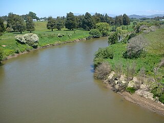
Te Rore was in the 1850s an important transhipment point on New Zealand's Waipā River, between the agriculture of the Waikato basin and its Auckland market. That was ended in 1864 by the Invasion of the Waikato, when Te Rore was, for a few months, part of the supply route to four redoubts set up nearby. It is now a rural community in the Waipa District, 6 km (3.7 mi) north of Pirongia and roughly the same distance south of Ngāhinapōuri on State Highway 39.

References

  1. 1 2 "ArcGIS Web Application". statsnz.maps.arcgis.com. Retrieved 27 October 2022.
  2. 1 2 "Population estimate tables - NZ.Stat". Statistics New Zealand . Retrieved 25 October 2023.
  3. 1 2 3 4 Parker, Eris. "Hautapu". cambridgemuseum.org.nz. Cambridge Museum.
  4. Tourist Department album 2 (circa 1905 to 1912). National Library of New Zealand: New Zealand Tourist and Publicity Department.
  5. "Hautaphu". The News and Theatre Courier. 12 August 1936.
  6. Hautapu Mosaic aerial negatives, prints, transparencies, and index. National Library of New Zealand: NZ Aerial Mapping Ltd. 19 April 1950.
  7. Smallman, Elton Rikihana (14 December 2018). "Hautapu the new home of Waipā's largest industrial estate". Stuff. Waikato Times.
  8. Iremonger, Sophie (7 September 2019). "Huge factory taking shape". Good Local Media. Cambridge News.
  9. "Hautapu Sports". sporty.co.nz. Hautapu Sports.
  10. "Hautapu Sports and Recreation Club". sportwaikato.org.nz. Sport Waikato.
  11. Iremonger, Sophie (19 July 2019). "Hautapu to play season finale". Good Local Media. Cambridge News.
  12. Miezenbeek, Justin (4 May 2019). "Sports no match for undefeated Hautapu". Te Awamutu Rugby Sports & Recreation Club. tasports.co.nz.
  13. "Hautapu RSA memorial". nzhistory.govt.nz. Ministry for Culture and Heritage.
  14. "Cambridge (Hautapu) Public Cemetery". nzwargraves.org.nz. War Graves Project.
  15. 1 2 "Statistical area 1 dataset for 2018 Census". Statistics New Zealand. March 2020. Hautapu Rural (182000) and Hautapu (182400).
  16. 2018 Census place summary: Hautapu
  17. 2018 Census place summary: Hautapu Rural
  18. "Hautapu School Official School Website". hautapu.school.nz.
  19. Education Counts: Hautapu School
  20. "Hautapu School Education Review Office Report". ero.govt.nz. Education Review Office.