
Argyll and Bute is one of 32 unitary authority council areas in Scotland and a lieutenancy area. The current lord-lieutenant for Argyll and Bute is Jane Margaret MacLeod. The administrative centre for the council area is in Lochgilphead at Kilmory Castle, a 19th-century Gothic Revival building and estate. The current council leader is Robin Currie, a councillor for Kintyre and the Islands.

Loch Lomond is a freshwater Scottish loch which crosses the Highland Boundary Fault, often considered the boundary between the lowlands of Central Scotland and the Highlands. Traditionally forming part of the boundary between the counties of Stirlingshire and Dunbartonshire, Loch Lomond is split between the council areas of Stirling, Argyll and Bute and West Dunbartonshire. Its southern shores are about 23 kilometres (14 mi) northwest of the centre of Glasgow, Scotland's largest city. The Loch forms part of the Loch Lomond and The Trossachs National Park which was established in 2002.

Dunbartonshire or the County of Dumbarton is a historic county, lieutenancy area and registration county in the west central Lowlands of Scotland lying to the north of the River Clyde. Dunbartonshire borders Perthshire to the north, Stirlingshire to the east, Lanarkshire and Renfrewshire to the south, and Argyllshire to the west. The boundaries with Lanarkshire and Stirlingshire are split in two owing to the existence of an exclave around Cumbernauld.
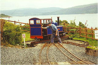
The Isle of Mull Railway was a 10+1⁄4 in gauge line, 1+1⁄4 miles (2.0 km) long, which ran from the ferry terminal at Craignure to Torosay Castle, on the Isle of Mull in the Scottish Inner Hebrides. Originally it was known as the Mull and West Highland Railway. The line was marketed as Scotland's original island passenger railway. The line opened in 1983 and closed in October 2010. A limited service operated over the 2011 Easter holiday and during summer 2011. The company's lease expired in October 2011. The track was lifted in October 2012.
Inchmurrin is an island in Loch Lomond in Scotland. It is the largest fresh water island in the British Isles.

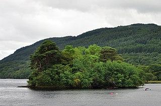
Inchcailloch is an islet on Loch Lomond in Scotland. It is 85 metres (279 ft) at its highest point. It is also known to some as Inchebroida.

Inchcruin is an island in Loch Lomond in Scotland. It is not to be confused with Creinch, which has occasionally been referred to as "Inchcroin".

Inchlonaig is an island in Loch Lomond in Scotland.
Inchtavannach, is one of the larger islands in Loch Lomond.
Inveruglas Isle is a small uninhabited island within Loch Lomond, and lies off the shore at Inveruglas opposite Inversnaid at the north end of the loch. It is opposite the Loch Sloy powerstation.

Eilean I Vow is a small island in Loch Lomond in west central Scotland. Other variants of the name include Ellan I Vow, Eilean a' Vow, Elanvow, Ellan Vhow and Island I Vow. The island is listed in 13th/14th century charters as "Elanvow".

Clairinsh or Clairinch is an island in Loch Lomond, central Scotland.

Fraoch Eilean is a small island in Loch Lomond, Scotland. Its name means "heather island" in Scottish Gaelic.

Aber Isle or Aber Inch is a small island in Loch Lomond, in west central Scotland. It is near the mouth of the River Endrick, by the abandoned village of Aber, and is 1⁄2 mile from Clairinch. Its name derives from the Celtic word for the mouth of a river, or Gaelic eabar meaning "mud, mire".

The Ross Isles are two small islands in Loch Lomond, in west central Scotland.

The Loch Lomond and Cowal Way is a waymarked footpath through the Cowal peninsula, in Argyll and Bute, between Portavadie on Cowal and Inveruglas on Loch Lomond side. It was formerly known as the Cowal Way, but was renamed in December 2018 to reflect the fact that half of the route lies with the Loch Lomond and The Trossachs National Park. The way is 92 kilometres (57 mi) long, and is suitable for both walkers and mountain bikers. Much of the route is also suitable for experienced horseriders, although in some places steps, narrow footbridges and gates may restrict access for horses. A review to identify these obstacles and suggest alternative routes and/or remedial measures was undertaken in 2016.
Inveruglas was a remote temporary private railway station near the hamlet of Inveruglas, Argyll and Bute, Scotland. Opened in 1945 by the LNER, it was built in connection with the construction of the Sloy Hydro-Electric facility and was located on the Ardlui side of the Inveruglas Viaduct and recorded to be out of use by around 1948.
Faslane Platform railway station or Faslane Junction Platform railway station was a temporary private railway station located near the Stuckendoff PoW camp, Shandon, Argyll and Bute, Scotland. Opened in 1945 by the LNER in connection with the construction of the Loch Sloy Hydro-Electric facility and was located on the Shandon side of the Chapel Burn and recorded to be out of use by around 1949 in the British Railways era.

The Great Trossachs Path is a 48-kilometre (30 mi) long-distance footpath through the Trossachs, in the Stirling council area of Scotland. It runs between Callander in the east and Inversnaid on the banks of Loch Lomond in the west, passing along the northern shores of Loch Katrine and Loch Arklet. The path is suitable for walkers and cyclists; much of the route is also suitable for experience horse riders, although the middle section along the shoreline of Loch Katrine is tarmacked and so may not be ideal for horses.

The Three Lochs Way is a 55-kilometre (34 mi) long-distance path in Argyll and Bute in Scotland that links Balloch and Inveruglas. The path crosses the Highland Boundary Fault, which divides the Scottish Highlands from the Lowlands, and is named for the three major lochs linked by the route: Loch Lomond, the Gare Loch and Loch Long. About 1,500 people use the path every year, of whom about 300 complete the entire route.