
Surrey is a ceremonial county in South East England and one of the home counties. It is bordered by Greater London to the northeast, Kent to the east, East and West Sussex to the south, and Hampshire and Berkshire to the west. The largest settlement is Woking.

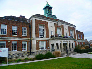
Reigate and Banstead is a local government district with borough status in Surrey, England. Its council is based in Reigate and the borough also includes the towns of Banstead, Horley and Redhill. Parts of the borough are within the Surrey Hills, a designated Area of Outstanding Natural Beauty. Northern parts of the borough, including Banstead, lie inside the M25 motorway which encircles London.

Tandridge is a local government district in east Surrey, England. Its council is based in Oxted, although the largest settlement is Caterham; other notable settlements include Warlingham, Godstone and Lingfield. In mid-2019, the district had an estimated population of 88,129.
The CR postcode area, also known as the Croydon postcode area, is a group of eight postcode districts in England, within ten post towns. These cover parts of southern Greater London and north-east Surrey.

East Surrey is a constituency represented in the House of Commons of the UK Parliament since 2019 by Claire Coutinho, a Conservative serving as Secretary of State for Energy Security and Net Zero. The seat covers an affluent area in the English county of Surrey.
Chaldon is a village and civil parish in the Tandridge District of Surrey, England. The village is situated high on the North Downs, immediately west of Caterham and 15.8 miles (25.4 km) south of Charing Cross, the traditional centre of London.

Banstead is a town in the borough of Reigate and Banstead in Surrey, England. It is 3 miles (5 km) south of Sutton, 5 miles (8 km) south-west of Croydon, 8 miles (13 km) south-east of Kingston-upon-Thames, and 13 miles (21 km) south of Central London.

Coulsdon and Purley Urban District was a local government district in northeast Surrey from 1915 to 1965. The local authority was Coulsdon and Purley Urban District Council. The former area of the district is now mostly part of the London Borough of Croydon in Greater London, with parts in the Tandridge District and the Borough of Reigate and Banstead in Surrey.

Penge was a civil parish and a local government district located to the southeast of London, England. It included the settlements of Penge, Anerley and part of Crystal Palace. It was part of the London postal district, Metropolitan Police District and, from 1933, the London Passenger Transport Area. In 1965 the urban district was abolished by the London Government Act 1963 and it became part of Greater London, being combined with other districts to form the London Borough of Bromley.

The London Borough of Croydon has over 120 parks and open spaces within its boundaries, ranging from the 200 acre (80ha) Selsdon Wood Nature Reserve to many recreation grounds and sports fields scattered throughout the Borough. Croydon covers an area of 86.52 km², the 256th largest district in England. Croydon's physical features consist of many hills and rivers that are spread out across the borough and into the North Downs, Surrey and the rest of South London. Some of the open spaces in Croydon form part of the well-known London LOOP walks where the first section was opened on 3 May 1996 with a ceremony on Farthing Downs in Coulsdon. As a borough in Outer London it also contains some open countryside in the form of country parks. Croydon Council is associated with several other boroughs who are taking part in the Downlands Countryside Management Project. These boroughs are Sutton; and by Surrey County Council; the City of London Corporation; the Surrey districts of Reigate and Banstead and Tandridge; and the Countryside Agency. An additional partner is Natural Britain.

Surrey County Council is the county council for the non-metropolitan county of Surrey, England. The council is composed of 81 elected councillors, and in all but one election since 1974 the Conservative Party has held the majority. The leader of the council is Tim Oliver.
Croydon was a rural district in north east Surrey, England, United Kingdom, from 1894 to 1915. It was created by the Local Government Act 1894 and replaced the Croydon Rural Sanitary District. The district surrounded the County Borough of Croydon to the south, east and west.

Sutton and Cheam was a local government district in northeast Surrey, England from 1882 to 1965.
Beddington and Wallington was, from 1915 to 1965, a local government district in north east Surrey, England. It formed part of the London suburbs, lying within the Metropolitan Police District and the London Passenger Transport Area. In 1965 it was abolished on the creation of Greater London.

Caterham and Warlingham was an Urban District of Surrey in England until 1974.
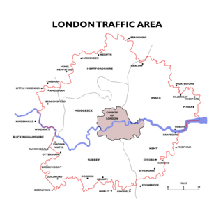
The London Traffic Area was established by the London Traffic Act 1924 to regulate the increasing amount of motor traffic in the London area. The LTA was abolished in 1965 on the establishment of the Greater London Council.

Woodmansterne is a village in the borough of Reigate and Banstead, Surrey, bordering Greater London, England. It sits on a small plateau of and a southern down slope of the North Downs and its ecclesiastical parish borders continue to span old boundaries and reach into Chipstead, Coulsdon and Wallington.
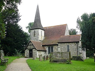
Chelsham and Farleigh is a civil parish in the Tandridge District of Surrey, England. The parish is high on the North Downs and centred 14 miles (23 km) south-southeast of central London and it adjoins the Greater London boundary; it is a predominantly rural/wooded parish aside from minority of land used for homes and gardens. Other than the villages of Chelsham and Farleigh, the parish also includes the hamlet of Fickleshole. The parish was created on 1 April 1969 as an amalgamation of its two named small villages.
Reigate was a hundred in what is now Surrey, England. It was geographically consonant with the southern two thirds of Borough of Reigate and Banstead together with two parishes in Tandridge and fractions of former parishes in the London Borough of Croydon and Borough of Crawley, West Sussex. Accordingly, it included the medieval-established town of Reigate with its motte castle and land which become the towns of Redhill and Horley.
Godstone Rural District was a rural district in Surrey, England from 1894 to 1974, covering an area in the south-east of the county.
