Watagans is a national park located in New South Wales, Australia, 99 kilometres (62 mi) north of Sydney.
Holderen is a lake on the border between Sweden and Norway. The 1.83-square-kilometre (0.71 sq mi) Norwegian part is located inside Blåfjella–Skjækerfjella National Park in the municipality of Snåsa in Trøndelag county. The 6.44-square-kilometre (2.49 sq mi) Swedish part is located in the municipality of Åre in Jämtland County. The lake lies about 3 kilometres (2 mi) south of the lake Grøningen.
Kingen is a lake on the border between Sweden and Norway. The Norwegian part is located in the municipality of Lierne in Trøndelag county, and the Swedish part is located in the municipality of Krokom in Jämtland County. It lies south of the larger lake Rengen.

Korea JoongAng Daily is the English edition of the South Korean national daily newspaper JoongAng Ilbo. The newspaper was first published on October 17, 2000, originally named as JoongAng Ilbo English Edition. It mainly carries news and feature stories by staff reporters, and some stories translated from the Korean language newspaper.
Polotsk Airport is a civilian airfield in Belarus, located 9 km south of Polotsk.

Edward River, or Kyalite River, an anabranch of the Murray River and part of the Murray–Darling basin, is located in the western Riverina region of south western New South Wales, Australia.
Foldsjøen is a reservoir located on the border of Møre og Romsdal and Trøndelag counties in Norway. It is located in the municipalities of Surnadal and Rindal. The lake is dammed from the Folda River and the water is used in the Trollheim power station. Slightly more elevated and directly to the south is the Gråsjøen reservoir, which is also behind a hydro-power dam.
Rounds Mountain, 2,257 feet (688 m), is a prominent peak in the Taconic Mountains of western Massachusetts and adjacent New York. The west side of the mountain and summit are located in New York; the east side is located within Massachusetts. The summit a bald; the slopes are wooded with northern hardwood tree species. It is notable for its views of the Hudson River Valley to the west and the Green River and Kinderhook Creek valleys of Hancock, Massachusetts to the east. The 35 mi (56 km) Taconic Crest Trail traverses the mountain. Much of the upper slopes and summit are within protected conservation land.
The Little Weir River, an anabranch of the Barwon River within the Murray–Darling basin, is located in the South Downs district of Queensland and the Orana district of New South Wales, Australia.

Pages River, a perennial river of the Hunter River catchment, is located in the Hunter region of New South Wales, Australia.
Wangat River, a perennial river of the Hunter River catchment, is located in the Hunter region of New South Wales, Australia.

South Carlsbad State Beach is a public beach located in Carlsbad, California.
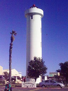
The Milnerton Lighthouse, commissioned on 1960-03-10, is located on Table Bay shore in Milnerton, South Africa. Its red sector covers Robben Island.

Wakool River, an anabranch of the Edward River that is part of the Murray River catchment within the Murray–Darling basin, is located in the western Riverina region of south western New South Wales, Australia.
Maria River, a watercourse of the Hastings River catchment, is located in the Mid North Coast region of New South Wales, Australia.
Richmond Mountain is a mountain located in the Catskill Mountains of New York east-northeast of Hunter. Richtmyer Peak is located northeast, Bump Mountain is located south, Steenburg Mountain is located north, and Ashland Pinnacle is located west-southwest of Richmond Mountain.
Ashland Pinnacle is a pillar in Greene County, New York. It is located in the Catskill Mountains north-northeast of Ashland. The Knob is located south, and Huntersfield Mountain is located west of Ashland Pinnacle.
Nausimachion was a coastal town of ancient Bithynia located on the Bosphorus.
Proochthoi or Brochthoi was a coastal town of ancient Bithynia located on the Bosphorus.
Lysinia or Lysinoe (Λυσινόη) was a town in the north of ancient Pisidia and later assigned to Pamphylia. Hierocles has the name as Lysenara (Λυσήναρα). It was located on the south of the Ascania Lacus, and west of Sagalassus.
