Wapta Mountain

Last updated
Wapta Mountain
Fossil Ridge.jpg
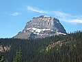
Wapta Mountain marks the end of Fossil Ridge
Highest point
Elevation 2,778 m (9,114 ft) [1] [2]
Listing Mountains of British Columbia
Coordinates 51°27′05″N116°28′39″W / 51.45139°N 116.47750°W / 51.45139; -116.47750 [3]
Geography
Canada British Columbia relief location map.jpg
Red triangle with thick white border.svg
Location in SE British Columbia
Country Canada
Province British Columbia
District Kootenay Land District
Protected area Yoho National Park
Parent range President Range
Topo map NTS 82N8 Lake Louise [3]
Climbing
First ascent 1901 [4]

Wapta Mountain is a mountain located in the Canadian Rockies between Emerald Lake and Yoho Valley in Yoho National Park, British Columbia, Canada. It stands just north of the ridge containing the Burgess Shale fossil beds. Along with The Vice President and Mount Burgess, Wapta Mountain forms the backdrop to Emerald Lake, and marks the southern end of the President Range.

In 1901, James Outram, J. H. Scattergood, and their guide C. Bohren, became the first people to ascend Wapta Mountain. [4] Wapta Mountain overlooks Takakkaw Falls (1,247 feet), the second tallest waterfall in western Canada. The word "Wapta" means "river" in the Stoney language. [3]

Related Research Articles

<span class="mw-page-title-main">Yoho National Park</span> National park in British Columbia, Canada

Yoho National Park is a national park of Canada. It is located within the Rocky Mountains along the western slope of the Continental Divide of the Americas in southeastern British Columbia, bordered by Kootenay National Park to the south and Banff National Park to the east in Alberta. The word Yoho is a Cree expression of amazement or awe, and it is an apt description for the park's spectacular landscape of massive ice fields and mountain peaks, which rank among the highest in the Canadian Rockies.

<span class="mw-page-title-main">Mount Collie</span> Mountain in Yoho NP, BC, Canada

Mount Collie is a mountain in Yoho National Park, located on the western boundary of the Wapta Icefield in Canada. The mountain was named in 1897 by Charles S. Thompson after J. Norman Collie, an accomplished mountaineer and early explorer of the Canadian Rockies.

<span class="mw-page-title-main">Emerald Lake (British Columbia)</span>

Emerald Lake is a freshwater lake located in Yoho National Park, British Columbia, Canada. Yoho National Park is one of the 4 contiguous National Parks in the heart of Canada's Rocky Mountains, along the boundary of British Columbia and Alberta Provinces, the other Parks are Kootenay, Jasper, and Banff.

<span class="mw-page-title-main">Kicking Horse River</span> River in British Columbia, Canada

The Kicking Horse River is in the Canadian Rockies of southeastern British Columbia, Canada. The river was named in 1858, when James Hector, a member of the Palliser Expedition, reported being kicked by his packhorse while exploring the river. Hector named the river and the associated pass as a result of the incident. The Kicking Horse Pass, which connects through the Rockies to the valley of the Bow River, was the route through the mountains subsequently taken by the Canadian Pacific Railway when it was constructed during the 1880s. The railway's Big Hill and associated Spiral Tunnels are in the Kicking Horse valley and were necessitated by the steep rate of descent of the river and its valley.

<span class="mw-page-title-main">Mount Field (British Columbia)</span>

Mount Field is a mountain located about 4 km (2 mi) northeast of the town of Field in Yoho National Park, Canada. The mountain was named in 1884 after Cyrus West Field, an American merchant who had laid the first Atlantic cable, 1858, a second in 1866; Mr. Field was visiting the Canadian Rockies the year as a guest of the CPR who were building the national railway, at the naming of a station and a mountain. Precipitation runoff from Mount Field drains into the Kicking Horse River. Topographic relief is significant as the summit rises 1,360 meters (4,462 feet) above the river in two kilometers (1.2 mile). The Trans-Canada Highway traverses the southern foot of the mountain.

<span class="mw-page-title-main">Saint Nicholas Peak (Canada)</span> Mountain in Canada

Saint Nicholas Peak is a 2,938-metre (9,639-foot) mountain summit in the Rocky Mountains of Canada. It is located on the Continental Divide, on the Alberta-British Columbia border, in both Banff National Park and Yoho National Park. It lies at the eastern edge of the Wapta Icefield, and is part of the Waputik Mountains which are a sub-range of the Canadian Rockies.

<span class="mw-page-title-main">Waputik Icefield</span> Glacier in Canada

The Waputik Icefield is located on the Continental divide in the Canadian Rocky Mountains, in the provinces of British Columbia and Alberta. It is developed on the heights of the Waputik Range in the Central Main Ranges.

<span class="mw-page-title-main">Wapta Icefield</span> Glacier in Alberta and British Columbia, Canada

The Wapta Icefield is a series of glaciers located on the Continental Divide in the Waputik Mountains of the Canadian Rockies, in the provinces of British Columbia and Alberta, in Yoho National Park in the Canadian Rockies. The icefield is shared by Banff and Yoho National Parks and numerous outlet glaciers extend from the icefield, including the Vulture, Bow and Peyto Glaciers. Runoff from the icefields and outlet glaciers supply water to both the Kicking Horse and Bow Rivers, as well as numerous streams and lakes.

The Stanley Mitchell hut is an alpine hut located at an altitude of 2,060 metres (6,759 ft) in the Little Yoho Valley in Yoho National Park, British Columbia, Canada. It sits in a small meadow not far from the base of a mountain called The President. It serves as a base for hiking, scrambling, ski-touring and climbing the nearby mountains. The hut is maintained by the Alpine Club of Canada.

<span class="mw-page-title-main">The President (mountain)</span>

The President is a mountain peak on The President/Vice-President Massif of the President Range, in eastern British Columbia. It is just north of Emerald Lake in Yoho National Park, near the Alpine Club of Canada's Stanley Mitchell hut.

<span class="mw-page-title-main">Mount Burgess</span> Mountain in Yoho NP, BC, Canada

Mount Burgess, 2,599 m (8,527 ft), is a mountain in Yoho National Park and is part of the Canadian Rockies. It is located in the southwest buttress of Burgess Pass in the Emerald River and Kicking Horse River Valleys.

<span class="mw-page-title-main">Mount Victoria (Bow Range)</span> Mountain in the country of Canada

Mount Victoria, 3,464 metres (11,365 ft), is a mountain on the border between British Columbia and Alberta in the Canadian Rockies. It is located just northeast of Lake O'Hara in Yoho National Park and is also part of Banff National Park and is on the Continental Divide. The mountain has two peaks, the south being the highest while the north peak is slightly lower at 3,388 metres (11,115 ft).

<span class="mw-page-title-main">Stephen Formation</span>

The Stephen Formation is a geologic formation exposed in the Canadian Rockies of British Columbia and Alberta, on the western edge of the Western Canada Sedimentary Basin. It consists of shale, thin-bedded limestone, and siltstone that was deposited during Middle Cambrian time. It is famous for the exceptional preservation of soft-bodied fossils: the Burgess Shale biota. The formation overlies the Cathedral escarpment, a submarine cliff; consequently it is divided into two quite separate parts, the 'thin' sequence deposited in the shallower waters atop the escarpment, and the 'thick' sequence deposited in the deeper waters beyond the cliff. Because the 'thick' Stephen Formation represents a distinct lithofacies, some authors suggest it warrants its own name, and dub it the Burgess Shale Formation. The stratigraphy of the Thin Stephen Formation has not been subject to extensive study, so except where explicitly mentioned this article applies mainly to the Thick Stephen Formation.

<span class="mw-page-title-main">Mount Olive (Canadian Rockies)</span> Mountain in Canada

Mount Olive is located on the Continental Divide, on the Alberta-British Columbia border, in both Banff National Park and Yoho National Park. It lies on the eastern edge of the Wapta Icefield, and is part of the Waputik Mountains. It was named in 1898 by H.B. Dixon after his wife Dixon, Olive.

<span class="mw-page-title-main">Waputik Mountains</span> Subrange of the Park Ranges in Alberta and British Columbia, Canada

The Waputik Mountains are a mountain range of the Canadian Rockies, located on the Continental Divide between Banff and Yoho National Park. Covering an area of 1,069 square kilometres (413 sq mi), the range is located west of the Howse, Blaeberry and Amiskwi Rivers and east of the Bow and Mistaya Rivers and south to Kicking Horse Pass. Named in 1884 by George M. Dawson, "waputik" is the Stoney Indian word for white goat.

<span class="mw-page-title-main">Paget Peak</span> Mountain in Yoho NP, British Columbia, Canada

Paget Peak is a mountain in Yoho National Park, British Columbia, Canada. It is readily accessible via a hiking trail.

<span class="mw-page-title-main">Michael Peak</span>

Michael Peak is a 2,701-metre (8,862-foot) mountain summit located in Yoho National Park, in the Canadian Rockies of British Columbia, Canada. Its nearest higher peak is The President, 4.0 km (2.5 mi) to the west-northwest. Both are part of the President Range which is a subset of the Waputik Mountains. Michael Peak is a landmark seen 4.5 kilometres north-northeast of Emerald Lake, three kilometres southwest of Takakkaw Falls, and 10 kilometres north of Field, British Columbia.

<span class="mw-page-title-main">Emerald Peak (Yoho)</span> Mountain in Yoho NP, British Columbia, Canada

Emerald Peak is a 2,701-metre (8,862-foot) mountain summit located in Yoho National Park, in the Canadian Rockies of British Columbia, Canada. Its nearest higher peak is Mount Carnarvon, 1.7 km (1.1 mi) to the northwest. Both are part of the President Range which is a subset of the Waputik Mountains. Emerald Peak is visible from Emerald Lake, rising 1,256-metre (4,121-foot) above the northwest shore. The mountain's name was officially adopted in 1924 when approved by the Geographical Names Board of Canada, in association with Emerald Lake, which in turn was named in 1900 on account of its color.

<span class="mw-page-title-main">Mount Carnarvon</span>

Mount Carnarvon is a 3,046-metre (9,993-foot) mountain summit located in the Kiwetinok River Valley of Yoho National Park, in the Canadian Rockies of British Columbia, Canada. Its nearest higher peak is The President, 3.9 km (2.4 mi) to the north-northeast. Both are part of the President Range which is a subset of the Waputik Mountains. Mount Carnarvon is situated five kilometers northwest of Emerald Lake, but is hidden from view behind Emerald Peak. However, Carnarvon is visible from Highway 1, the Trans-Canada Highway. The months July through September offer the most favorable weather for viewing or climbing Mount Carnarvon.

References

  1. "Wapta Mountain". cdnrockiesdatabases.ca. Retrieved 2019-08-17.
  2. Lake Louise & Yoho (Map). 1:50000. Cochrane, AB, CA: Gem Trek Publishing. 2001. § C2.
  3. 1 2 3 "Wapta Mountain". BC Geographical Names . Retrieved 2016-07-02.
  4. 1 2 "Wapta Mountain". Bivouac.com. Retrieved 2016-07-02.
Wapta Mountain Wapta Mountain.jpg
Wapta Mountain