Warragamba Dam - Haviland Park

Last updated

Warragamba Dam - Haviland Park
Australia New South Wales relief location map.png
Red pog.svg
Location of Warragamba Dam - Haviland Park in New South Wales
LocationWarragamba Dam, Warragamba, Wollondilly Shire, New South Wales, Australia
Coordinates 33°53′13″S150°35′55″E / 33.8869°S 150.5986°E / -33.8869; 150.5986 Coordinates: 33°53′13″S150°35′55″E / 33.8869°S 150.5986°E / -33.8869; 150.5986
OwnerWater NSW
Official nameWarragamba Dam - Haviland Park
TypeState heritage (landscape)
Designated18 November 1999
Reference no.1375
TypeReserve
CategoryParks, Gardens and Trees

Warragamba Dam - Haviland Park is a heritage-listed former farm, dam, timber getting, Gundungurra traditional lands and squatter's land and now parkland located at Warragamba Dam in the south-western Sydney settlement of Warragamba in the Wollondilly Shire local government area of New South Wales, Australia. The property is owned by Water NSW, an agency of the Government of New South Wales. It was added to the New South Wales State Heritage Register on 18 November 1999. [1]

Contents

History

One of the first places in the Gundungurra traditional homelands that most appealed to the Anglo-Celt settlers were the river flats of the Burragorang Valley (now flooded under Warragamba Dam). Even before the valley was officially surveyed in 1827-8, many early settlers were already squatting on blocks that they planned to officially occupy following the issue of freehold title grants. From the Burragorang Valley and using Aboriginal pathways, other valleys to the west were occupied and developed by the settlers with construction of outstations and stock routes. These cattle entrepreneurs were then followed by cedar-wood extractors and miners. [1]

The Gundungurra traditional owners resisted the taking of their lands, and, relying on various laws of the colony at the time, continually applied for official ownership. Although their individual claims failed, in some kind of recognition of the significance of the designated tracts of land claimed, six Aboriginal reserves (under the control of the NSW Aborigines Protection Board) were formally declared in the Burragorang Valley. Even after these reserves were revoked, many of the traditional owners remained, quietly refusing to leave their traditional homelands. [1]

Finally pushed into the "Gully", a fringe development in West Katoomba from about 1894, the Gully community stayed together for more than 60 years until dispossessed of the Gully by the then Blue Mountains Shire Council so a group of local businessmen could develop a speedway that became known as the Catalina Race Track. The Gully people kept talking about areas of land they had walked in as children - the nearby Megalong and Kanimbla Valleys and the Burragorang Valley. They knew of the profound significance of these valleys for their parents and grandparents. [2] [1]

Warragamba Dam

Warragamba Dam was constructed from 1947 to 1960, along with adjacent Warragamba township, by the Metropolitan Water Sewerage and Drainage Board; with its own forces with various items being let on contract. Constructed of mass concrete in block sections, a total of two point seven  billion tonnes ; two point seven billion long tons (three billion short tons ) of concrete was used to construct the straight gravity wall which featured a height of 137 metres (449 ft) from foundation to crest. [1]

During the 1960s the public facilities and picnic areas were developed and finalised. Haviland Park was formed out of the original dam construction site and platforms on the eastern bank of the dam, with development, part of the beautification program, essentially undertaken in the early 1960s. [1]

Haviland Park was officially opened by the president of the Metropolitan Water Sewerage and Drainage Board, E. J. Walder, in December 1965. The name commemorates the role of President Haviland, Associate Professor of Architecture at the University of Sydney, who was consulted on the design of the parks at Warragamba. Part of these beautification works involved the removal of much of the dam's construction and plant equipment and establishment of a planned landscape feature for use by the general public. In a design sense, Haviland Park is the most formal of the parks at Warragamba. [1]

Generally, landscaping as part of public facilities was provided at Cataract, Cordeaux and Avon, Nepean and Wornora dams and the Prospect Reservoir. They all contained similar features, e.g., the provision of picnic areas with hot water, barbeques and wood provided, seats and tables, lawns, shade trees, shelters, rubbish disposal points, and toilet facilities. The landscaping tended to mirror the construction phase of the Dam. Haviland Park for instance contains numerous archaeological, architectural and engineering remains, which show evidence of various construction phases. It is believed that several of the exotic species (Japonica, Weeping Wisteria, and Bauhinias) were transplanted from the maintenance area at the main weir because they were highly valued by the workers. [1]

The park area was once again used as a construction site, during the 1998-2004 construction of the auxiliary spillway to reduce the impacts of flooding, the required location and configuration of which has resulted in the reduction of the size of Haviland Park by about a third. [1]

The precinct has been closed since 1997 due to major construction works at the site – construction of the auxiliary spillway. [1] [3]

The provision of picnic areas, hot water, barbecues, seats and tables, lawns, shade trees, rubbish disposal points and toilet facilities was similar to that provided by the board at other dam sites in New South Wales. Some 10-hectare (25-acre) of picnic grounds were landscaped to include visitor facilities such as an oval, running tracks, tennis courts, picnic shelters, electric BBQs, boiling water outlets, group shelters and a kiosk. [1]

On completion the area, located to the south of the dam wall, consisted of a ridge between Lavender Creek and Folly Creek divided by a series of roadways and car parks which provided viewing access to the dam and a recreational park for visitors. [1]

The principal feature of the park was a double avenue of sweet gum ( Liquidambar styraciflua ) trees along the access of the ridge punctuated by cross roads and featuring a weather shelter and a fountain design by Spooner. Around the perimeter of the park several buildings and facilities original to the dam construction were retained. [1]

In June 2016 the NSW Government announced that it would allocate $58 million to raise the dam wall by 14 metres (46 ft) to prevent flooding disaster to downstream towns. [4] [1]

Description

Wraragamba Dam is located in a narrow gorge within the Warragamba River, approximately 65 kilometres (40 mi) south-west of Sydney and 15 kilometres (9.3 mi) south of Penrith. The south-eastern corner of the site connects to the Warragamba township established as part of the Warragamba Supply Scheme. The northern side of the dam is adjacent to the Blue Mountains National Park. East of the dam is a large entry precinct and picnic grounds, and Haviland Park is between this precinct and the dam itself and spillways. [1]

Haviland Park is to the dam's east and covers 4.0 hectares (10 acres) contains plantings and built features which are substantially intact from the time of establishment in the 1960s. There is remnant evidence of the construction apparatus, including rail tracks, building footings, concrete anchors, former aggregate conveyor tunnel, existing terraced road alignments, 17-tonne; 17-long-ton (19-short-ton) cableway and associated machinery. The existing timber and fibro systems office (former engineers office) and information centre (former staff mess) which constitute the only two remaining buildings from the original construction site. [1]

Haviland Park now comprises two open, relatively level grassed areas bounded by native and introduced trees and shrubs. The most prominent are two rows of sweet gums (Liquidambar styraciflua) planted during the 1960s. The areas are bounded by access roads with newly formed car parking areas and kerbs also provided. The precinct is the major open space recreation area of the dam but has been closed since 1997 due to construction works at the site. [3] [1]

Haviland Park covers an area of 10 acres contains plantings and built features which are substantially intact from the time of establishment. There is remnant evidence of the construction apparatus, including rail tracks, building footings, concrete anchors, former aggregate conveyor tunnel, existing terraced road alignments, 19 ton cableway and associated machinery. [1]

The tree lined avenue of exotic and indigenous plantings includes; coastal redwood (Sequoia sempervirens), Chinese tallow tree (Sapium sabiferum), brush box (Lophostemon confertus), sweet gum (Liquidambar styraciflua), paperbark (Melaleuca sp.), Jacaranda, camphor laurel (Cinnamomum camphora), plus major species of Monterey pine (Pinus radiata), Eucalypt, and she-oak (Casuarina sp.). [1]

The site is surrounded by a dry packed stone retaining wall. A landscaped exotic garden and steps adjacent to the existing picnic shelter to the north. This garden contains significant plantings, in this instance of Cacti, Agave, succulents, and Yuccas. Access is provided to the Folly Creek area. [1]

The facilities available for public use include, parking areas, viewing points, picnic areas with tables and seats, barbeque fireplaces, with wood provided, boiling water installations, children's playgrounds, shelter sheds, public toilets, and drinking fountains. The existing timber and fibro systems office (former engineers office) and information centre (former staff mess) which constitute the only two remaining buildings from the original construction site. [1]

Modifications and dates

A survey of the features in the park was carried out for the 2006 Conservation Management Plan (CMP). No features of note were recorded in the area proposed for the new Visitor Centre. [1]

To the west, down the side of the ridge, are the remains of two former roads, now truncated at their northern end. [1]

To the south of the site the principal site features are:

Towards the east side other trees, including Melaleucas and pines are extant. [6] [1]

Heritage listing

Haviland Park has a high level of state heritage significance for several reasons. It represents the pinnacle of quality visitor facilities provided by the Board at Dam sites. It contains numerous archaeological, architectural and engineering remnants from the dam's construction. The Park displays a high degree of formality and planning and is rich in both exotic and native botanical species which contribute to the landscape significance of the park. It commemorates the role of Haviland, without whom the numerous landscaped parks and reserves of the Dams would not have been established, nor executed with such high regard for design and formalism. It is highly valued by the community of New South Wales as a place for passive recreation, leisure activities and sightseeing pursuits. Sydney Water continues the role of maintaining Haviland Park and providing visitor facilities. [1]

Warragamba Dam - Haviland Park was listed on the New South Wales State Heritage Register on 18 November 1999 having satisfied the following criteria. [1]

The place possesses uncommon, rare or endangered aspects of the cultural or natural history of New South Wales.

This item is assessed as aesthetically rare statewide. This item is assessed as historically rare statewide. This item is assessed as scientifically rare statewide. This item is assessed as socially rare statewide. [1]

See also

Related Research Articles

Blue Mountains National Park Protected area in New South Wales, Australia

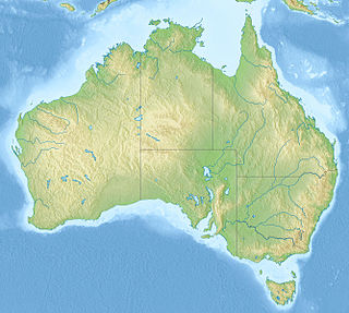
The Blue Mountains National Park is a protected national park that is located in the Blue Mountains region of New South Wales, in eastern Australia. The 267,954-hectare (662,130-acre) national park is situated approximately 80 kilometres (50 mi) west of Sydney, and the park boundary is quite irregular as it is broken up by roads, urban areas and inholdings. Despite the name mountains, the area is an uplifted plateau, dissected by a number of larger rivers. The highest point in the park is Mount Werong at 1,215 metres (3,986 ft) above sea level; while the low point is on the Nepean River at 20 metres (66 ft) above sea level as it leaves the park.

Nattai National Park Protected area in New South Wales, Australia

The Nattai National Park is a protected national park that is located in the Macarthur and Southern Highlands regions of New South Wales, in eastern Australia. 48,984-hectare (121,040-acre) It is situated approximately 150 kilometres (93 mi) southwest of the Sydney central business district and primarily encompasses the valley of the Nattai River, which is surrounded by spectacular sandstone cliffs. The park is covered in dry sclerophyll forest - mostly eucalypt and has fairly frequent forest fires. It is largely an untouched wilderness area and receives very few visitors, as it has virtually no facilities and is fairly remote, despite its proximity to Sydney.

Warragamba Dam Dam in Warragamba, New South Wales

Warragamba Dam is a heritage-listed dam in the outer South Western Sydney suburb of Warragamba, Wollondilly Shire in New South Wales, Australia. It is a concrete gravity dam, which creates Lake Burragorang, the primary reservoir for water supply for the city of Sydney. The dam wall is located approximately 65 kilometres (40 mi) to the southwest of Sydney central business district, near the town of Wallacia.

Lake Burragorang

Lake Burragorang is a man-made reservoir in the lower Blue Mountains of New South Wales, Australia, serving as a major water supply for greater metropolitan Sydney. The dam impounding the lake, the Warragamba Dam, is located approximately 60 kilometres (37 mi) southwest of the Sydney central business district.

Warragamba, New South Wales Town in New South Wales, Australia

Warragamba is a town in New South Wales, Australia, in Wollondilly Shire. Located on the eastern edge of the Blue Mountains, Warragamba is one and a half hour's drive west of Sydney. The name Warragamba comes from the aboriginal words Warra and Gamba meaning 'water running over rocks'.

Wentworth Falls, New South Wales Suburb of City of Blue Mountains, New South Wales, Australia

Wentworth Falls is a town in the Blue Mountains region of New South Wales, situated approximately 100 kilometres (62 mi) west of the Sydney central business district, and about 8 kilometres (5.0 mi) east of Katoomba, Australia on the Great Western Highway, with a Wentworth Falls railway station on the Main Western line. The town is at an elevation of 867 metres (2,844 ft) AHD . At the 2016 census, Wentworth Falls had a population of 6,076.

Coxs River

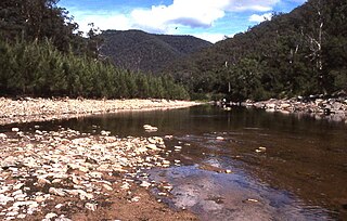
The Coxs River, a perennial river that is part of the Hawkesbury-Nepean catchment, is located in the Central Tablelands, Blue Mountains, and Macarthur regions of New South Wales, Australia.

Cataract Dam Dam in Cataract Road, Cataract, New South Wales

The Cataract Dam is a heritage-listed dam in Cataract, New South Wales, Australia, provides water to the Macarthur and Illawarra regions, the Wollondilly Shire, and metropolitan Sydney. It is one of four dams and weirs in the catchment of the Upper Nepean Scheme. Completed in 1907 under the supervision of Ernest Macartney de Burgh, the dam is currently owned by Water NSW, an agency of the Government of New South Wales. The dam was listed on the NSW State Heritage Register on 18 November 1999.

Cordeaux Dam Dam in Cordeaux River, Cordeaux, New South Wales

The Cordeaux Dam is a heritage-listed dam in Cordeaux, New South Wales, Australia. It provides water to the Macarthur and Illawarra regions, the Wollondilly Shire, and metropolitan Sydney. It is one of four dams and weirs in the catchment of the Upper Nepean Scheme. Completed in 1926 under the supervision of Ernest Macartney de Burgh, the dam is owned by Water NSW, an agency of the Government of New South Wales. It was listed on the New South Wales State Heritage Register on 18 November 1999.

Nepean Dam Dam in Avon Dam Road, Bargo, New South Wales

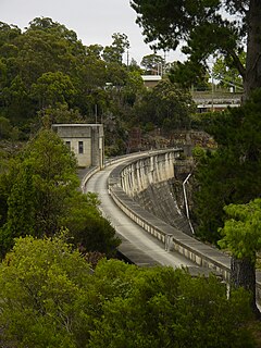
The Nepean Dam is a heritage-listed dam split across Avon in the Wingecarribee Shire and Bargo in the Wollondilly Shire, both in New South Wales, Australia. The reservoir created by the dam spreads across Avon, Bargo and also Yerrinbool in Wingecarribee Shire. The Nepean Dam is one of four dams and weirs in the catchment of the Upper Nepean Scheme, in New South Wales, Australia, and provides water to the Macarthur and Illawarra regions, the Wollondilly Shire, and metropolitan Sydney. Completed in 1935 under the supervision of Ernest Macartney de Burgh, the dam is currently managed by the Sydney Catchment Authority and is listed on the New South Wales State Heritage Register.

Avon Dam Dam in Avon Dam Road, Avon Dam, New South Wales

The Avon Dam is a heritage-listed dam in Avon, Wingecarribee Shire, New South Wales, Australia. It is one of four dams and weirs in the catchment of the Upper Nepean Scheme, providing water to the Macarthur and Illawarra regions, the Wollondilly Shire, and metropolitan Sydney. The arch dam across the Avon River was completed in 1927 under the supervision of Ernest Macartney de Burgh, the dam is currently managed by the Sydney Catchment Authority and is listed on the New South Wales State Heritage Register.

Woronora Dam Dam in south of Sydney, New South Wales

The Woronora Dam is a heritage-listed concrete gravity dam with an uncontrolled serpentine spillway across the Woronora River, located south of Greater Metropolitan Sydney, in the suburb of Woronora Dam, Sutherland Shire, New South Wales, Australia. The principal purpose of the dam is for potable water supply for Sydney's southern suburbs and the northern suburbs of the Illawarra region. The impounded 71,790-megalitre reservoir is also called Woronora Dam and is sometimes incorrectly called Lake Woronora. The dam was designed by G. E. Haskins, Chief Engineer and the Metropolitan Water, Sewerage and Drainage Board of NSW (MWS&DB) and built from 1927 to 1941 by the MWS&DB. The property is owned by the Sydney Catchment Authority, an agency of the Government of New South Wales. It was added to the New South Wales State Heritage Register on 18 November 1999.

Prospect Reservoir Dam in Western Sydney, New South Wales

The Prospect Reservoir is a heritage-listed 50,200-megalitre potable water supply and storage reservoir created by the Prospect Dam, across the Prospect Creek located in the Western Sydney suburb of Prospect, in New South Wales, Australia. The eastern bounds of the reservoir are a recreational area and the western periphery are within the bounds of Western Sydney Parklands. It was added to the New South Wales State Heritage Register on 18 November 1999.

Catalina Park

Catalina Park is a disused motor racing venue, located at Katoomba, in the Blue Mountains, New South Wales, Australia, and is recognised as an Aboriginal Place due to the long association of the local Gundungarra and Darug clans to the area.

Split Rock Dam Dam in North West Slopes, New South Wales

Split Rock Dam is a minor ungated concrete faced rock fill embankment dam with concrete chute spillway across the Manilla River upstream of Manilla in the north-western slopes region of New South Wales, Australia. The dam's purpose includes flood mitigation, irrigation, water supply and conservation. The impounded reservoir is called Split Rock Reservoir.

Warragamba River river in New South Wales, Australia

The Warragamba River, a river that is part of the Hawkesbury-Nepean catchment, is located in the Macarthur region of New South Wales, Australia.

Kings Tableland

The Kings Tableland is a plateau, located in the Blue Mountains in Wollondilly Shire, New South Wales, Australia. The ridge is an eroded remnant of a sandstone layer that is approximately 1,000 metres (3,300 ft) AMSL, situated immediately south of Wentworth Falls. The Tableland is the major southerly spur of the main spine of the Blue Mountains Range and forms the beginning of the Southern Escarpment, an unbroken series of tall sandstone cliffs which fringes the Jamison, Megalong, Kanimbla and Hartley Valleys.

Burragorang, New South Wales New South Wales, Australia

Burragorang or Burragorang Valley is a locality in the Macarthur Region of New South Wales, Australia, in Wollondilly Shire. It is home to Lake Burragorang, which is impounded by Warragamba Dam. It is located within the Blue Mountains National Park – specifically the Nattai National Park.

Central Gardens Nature Reserve

The Central Gardens Nature Reserve, also called Central Gardens, is a protected nature reserve located in the western suburbs of Sydney, New South Wales, Australia. Established in 1976, the 12-hectare (30-acre) reserve, garden and fauna and wildlife park is situated in the suburb of Merrylands and is managed by Cumberland Council. The park is regionally important and it attracts visitors outside the Cumberland local government area. The bushland contains remnants of Cumberland Plain Woodland and is approximately 3.5 hectares.

Coxs River track

The Coxs River track is a heritage-listed former walking track and road and now walking track at Cox's River Arms, Lake Burragorang/Warragamba Dam, City of Blue Mountains, New South Wales, Australia. The track is also known as the Warragamba Dam - Burragorang Valley - Wentworth Falls Track. The property is owned by the Sydney Catchment Authority, an agency of the Government of New South Wales. It was added to the New South Wales State Heritage Register on 18 November 1999.

References

  1. 1 2 3 4 5 6 7 8 9 10 11 12 13 14 15 16 17 18 19 20 21 22 23 24 25 26 27 28 29 30 31 32 33 34 35 "Warragamba Dam - Haviland Park". New South Wales State Heritage Register . Office of Environment and Heritage. H01375. Retrieved 2 June 2018.
  2. Johnson, 2009, 4.
  3. 1 2 Sydney Catchment Authority, 2007, 1.
  4. Nicholls, 17/6/16
  5. Clive Lucas Stapleton & Partners, 2008, 3
  6. Clive Lucas, Stapleton & Partners Pty Ltd, November 2006: pp 2–3

Bibliography

Attribution

CC-BY-icon-80x15.png This Wikipedia article was originally based on Warragamba Dam - Haviland Park , entry number 01375 in the New South Wales State Heritage Register published by the State of New South Wales and Office of Environment and Heritage 2018 under CC-BY 4.0 licence , accessed on 2 June 2018.