Warsaw Babice Airport

Last updated
Warsaw Babice Airport

Lotnisko Warszawa-Babice
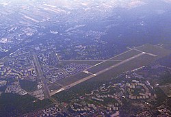
LotniskoBabice.jpg
View of the airport from the air to the southwest. The photo draws attention to Powstańców Śląskich Street which is a street on the path of the former second runway. The paved runway 10R/28L in use is only a part of its former length.
Summary
Airport typeCivil, sports, Interior Ministry
Serves Warsaw
Location Warsaw
Time zone UTC +1 ()
Elevation  AMSL 348 ft / 106.1 m
Coordinates 52°16′9.06″N20°54′25.98″E / 52.2691833°N 20.9072167°E / 52.2691833; 20.9072167 Coordinates: 52°16′9.06″N20°54′25.98″E / 52.2691833°N 20.9072167°E / 52.2691833; 20.9072167
Website Official site's English page
Runways
Direction LengthSurface
ftm
10R/28L1,300 x 90 mConcrete
10L/28R1,000 x 150 mGrass
A Yak-40 now used for training by the Military University of Technology in Warsaw PL Yak40 042.jpg
A Yak-40 now used for training by the Military University of Technology in Warsaw

Warsaw-Babice (ICAO code: EPBC, IATA code: QEB) is an airport in Warsaw, located in the residential district of Bemowo, near the border with the district of Bielany. It is also unofficially known as Bemowo.

Contents

The airport is administered by the Centre for Logistics "Warsaw-Babice" (Centrum Usług Logistycznych "Lotnisko Warszawa-Babice") and organisations based there include: the Warsaw Aero Club (Aeroklub Warszawski) and Polish Air Rescue (Lotnicze Pogotowie Ratunkowe).

It has been used for various events and celebrity arrivals including Michael Jackson (1996), Madonna (2009), AC/DC (2010), and the Sonisphere Festival (2010, 2011, 2012).

Infrastructure

The airport has a concrete runway 10R/28L, measuring 1,300 m x 90 m, and, parallel to it, a grass runway 10L/28R, measuring 1,000 m x 150 m.

The airport was established at the former military airport in Bemowo. It had two concrete runways 5/23 measuring 2,000 m x 80 m and 10R/28L measuring 2,500 m x 90 m. One of the former runways was used as an extension to the residential Powstańców Śląskich Street. Only part of the second, longer runway was used for the new airport.

Radio frequencies

History

The site of the current airport was used as a landing strip for Russian and German airplanes. In 1918, it was one of the bases for the Research Institute of Aviation Technology (Instytutu Badań Techniki Lotniczej - IBTL) which then changed into the Technical Institute of Aviation (Instytut Techniczny Lotnictwa - ITL).

The airport was reestablished after World War II, at "Szwedzkie Górki" (Swedish Hills) between Fort P (part of the Warsaw Fortress) and Boernerowo outside Warsaw (during this period, it was in the municipality of Gmina Blizne based in Old Babice, hence the name of the airport).

In 1959, a Boeing 707 transporting U.S. Vice-President Richard Nixon, used the airport.

Singer Michael Jackson performed at Bemowo on 20 September 1996 during his HIStory World Tour in front of 120,000 people.

Due to the heavy urbanization around the airport, to ensure safety and to ease the burden of airport operations for locals, a custom procedure (the only one of its kind in Poland) to circulate traffic was introduced, which caused controversy among pilots and instructors. There still is a conflict between the airport and local residents.

Bibliography

Related Research Articles

<span class="mw-page-title-main">Runway</span> Area of surface used by aircraft to takeoff from and land on

According to the International Civil Aviation Organization (ICAO), a runway is a "defined rectangular area on a land aerodrome prepared for the landing and takeoff of aircraft". Runways may be a man-made surface or a natural surface. Runways, taxiways and ramps, are sometimes referred to as "tarmac", though very few runways are built using tarmac. Takeoff and landing areas defined on the surface of water for seaplanes are generally referred to as waterways. Runway lengths are now commonly given in meters worldwide, except in North America where feet are commonly used.

<span class="mw-page-title-main">Instrument landing system</span> Ground-based visual aid for landing

In aviation, the instrument landing system (ILS) is a precision radio navigation system that provides short-range guidance to aircraft to allow them to approach a runway at night or in bad weather. In its original form, it allows an aircraft to approach until it is 200 feet (61 m) over the ground, within a 12 mile (800 m) of the runway. At that point the runway should be visible to the pilot; if it is not, they perform a missed approach. Bringing the aircraft this close to the runway dramatically increases the range of weather conditions in which a safe landing can be made. Other versions of the system, or "categories", have further reduced the minimum altitudes, runway visual ranges (RVRs), and transmitter and monitoring configurations designed depending on the normal expected weather patterns and airport safety requirements.

<span class="mw-page-title-main">Kai Tak Airport</span> Former airport of Hong Kong (1925—1998)

Kai Tak Airport was the international airport of Hong Kong from 1925 until 1998. Officially known as Hong Kong International Airport from 1954 to 6 July 1998, it is often referred to as Hong Kong International Airport, Kai Tak, or simply Kai Tak and Kai Tak International Airport, to distinguish it from its successor, Chek Lap Kok International Airport, built on reclaimed and levelled land around the islands of Chek Lap Kok and Lam Chau, 30 kilometres (19 mi) to the west.

<span class="mw-page-title-main">Orlando Sanford International Airport</span> Public airport in Sanford, Florida, United States

Orlando Sanford International Airport is in Sanford, Florida, United States, near Orlando. It was built as Naval Air Station Sanford, a Master Jet Base for carrier-based attack and reconnaissance aircraft, and was used by the U.S. Navy until 1969. The airport is owned and operated by the Sanford Airport Authority. It is a base for Allegiant Air.

<span class="mw-page-title-main">McGhee Tyson Airport</span> Airport in Alcoa, Tennessee, USA

McGhee Tyson Airport is a public/military airport 12 miles south of Knoxville, in Alcoa, Blount County, Tennessee, United States. It is named for United States Navy pilot Charles McGhee Tyson, who was killed in World War I.

<span class="mw-page-title-main">DeKalb–Peachtree Airport</span> Airport in the United States

DeKalb–Peachtree Airport is a county-owned, public-use airport in DeKalb County, Georgia, United States. The airport is located in the city of Chamblee, just northeast of Atlanta. It is also known commonly as Peachtree–DeKalb Airport, or simply PDK. Other names include Peachtree Airport, DeKalb Airport, or DeKalb County Airport. ASOS weather reports are produced 24 hours per day as "Chamblee". It has airline service with Ultimate Air Shuttle to Cincinnati and Southern Airways Express to Memphis and Destin.

<span class="mw-page-title-main">Siem Reap International Airport</span> International airport in Siem Reap, Cambodia

Siem Reap International Airport is an international airport serving Siem Reap, a popular tourist destination due to the nearby Angkor Wat temple complex. It is the second-busiest airport in Cambodia after Phnom Penh International Airport.

<span class="mw-page-title-main">Montgomery Regional Airport</span> Airport

Montgomery Regional Airport is a civil-military airport seven miles southwest of Montgomery, the capital of Alabama. Owned by the Montgomery Airport Authority, it is used for general aviation and military aviation, and sees two airlines.

<span class="mw-page-title-main">Arkansas International Airport</span> Airport

Arkansas International Airport is a public use airport located three nautical miles (6 km) northwest of the central business district of Blytheville, a city in Mississippi County, Arkansas, United States. It is owned by the Blytheville Gosnell Regional Airport Authority.

<span class="mw-page-title-main">North Texas Regional Airport</span> Airport

North Texas Regional Airport / Perrin Field is a county-owned airport in Grayson County, Texas between Sherman and Denison. Formerly Grayson County Airport, the airport was renamed in November 2007. Several buildings are occupied by businesses, Grayson County government agencies, and Grayson County College.

<span class="mw-page-title-main">Clinton-Sherman Industrial Airpark</span> Airport in Oklahoma, United States of America

The Clinton-Sherman Industrial Airpark, also known as the Oklahoma Air & Space Port is a spaceport in Washita County, Oklahoma, near the town of Burns Flat. The Federal Aviation Administration (FAA) granted a license to the site in June 2006 to the Oklahoma Space Industry Development Authority (OSIDA) to "oversee the takeoff and landing of suborbital, reusable launch vehicles." It also boasts the first space flight corridor, "The Infinity One"—which is about 152 miles long and averages about 50 miles wide—that is not in restricted airspace and does not interfere with Military Operations Areas (MOAs). The facility is an FAA licensed launch site, one of only 12 in the U.S. Individual operators must also secure a separate license in order to make space flights from the facility.

<span class="mw-page-title-main">Lenawee County Airport</span> Airport in Adrian, Michigan

Lenawee County Airport is a county-owned public-use airport located three miles (5 km) southwest of the central business district of Adrian, a city in Lenawee County, Michigan, United States. The airport is accessible by road from Cadmus Road, and is close to US-223. It is included in the Federal Aviation Administration (FAA) National Plan of Integrated Airport Systems for 2017–2021, in which it is categorized as a local general aviation facility.

<span class="mw-page-title-main">Treasure Coast International Airport</span> Airport in Fort Pierce, Florida

Treasure Coast International Airport is a public airport located three miles (5 km) northwest of the central business district of Fort Pierce, a city in St. Lucie County, Florida, United States. It is owned by the St. Lucie Board of County Commissioners.

Karnal Aerodrome is being operated as a pilot training institute owned and operated by Haryana Institute of Civil Aviation (HICA) under guidance of Civil Aviation Department, Government of Haryana. The flying school is spread over an area of 104 acres and is situated about 3 km east of Karnal in the state of Haryana, India.

<span class="mw-page-title-main">Hawkins Field (airport)</span> Airport in Mississippi, United States

Hawkins Field is a joint civil-military public airport in Jackson, Mississippi. It is owned by the City of Jackson and operated by the Jackson Municipal Airport Authority. The National Plan of Integrated Airport Systems for 2011–2015 called it a general aviation facility.

<span class="mw-page-title-main">Conroe-North Houston Regional Airport</span> Airport in Texas, United States

Conroe-North Houston Regional Airport is a public-use airport in Conroe, Texas, United States, 37 miles (60 km) north of the central business district of Houston. It is publicly owned by Montgomery County.

<span class="mw-page-title-main">Newport Municipal Airport (Arkansas)</span> Airport in Jackson County

Newport Municipal Airport is a city-owned public-use airport located five nautical miles northeast of the central business district of Newport, a city in Jackson County, Arkansas, United States. It is included in the National Plan of Integrated Airport Systems for 2011–2015, which categorized it as a general aviation airport.

Hawthorne–Feather Airpark is a privately owned public-use airport located three nautical miles (6 km) south of the central business district of Hillsborough, in Hillsborough County, New Hampshire, United States. The airport is situated in Deering, New Hampshire. It was formerly used by Hawthorne College in Antrim, New Hampshire to train student pilots.

<span class="mw-page-title-main">Port Alsworth Airport</span> Airport

Port Alsworth Airport is a private-use airport serving Port Alsworth which is located in the Lake and Peninsula Borough of the U.S. state of Alaska. As per Federal Aviation Administration records, the airport had 2,634 passenger boardings (enplanements) in calendar year 2019, an increase of 52.87% from the 1,723 enplanements in 2018.

<span class="mw-page-title-main">Pinjore Aerodrome</span> Civil Airstrip in Haryana, India used for general operations and pilot training

Pinjore Airfield is being operated as a pilot training institute owned and operated by Haryana Institute of Civil Aviation (HICA) under guidance of Civil Aviation Department, Government of Haryana. The flying school is spread over an area of 96 acres and is located on Pinjore - Baddi main highway near the cities of Kalka and Pinjore in the Panchkula district of the Indian state of Haryana.