Watford Gap

Last updated
Watford Gap: West Coast Main Line and M1 motorway in parallel WCML and M1.jpg
Watford Gap: West Coast Main Line and M1 motorway in parallel
Grand Union Canal at Watford Gap. Watford Gap - Grand Union Canal - geograph.org.uk - 71453.jpg
Grand Union Canal at Watford Gap.

Watford Gap is a low-lying area between two hills in the English Midlands, near Daventry and the village of Watford in Northamptonshire. Engineers from Roman times onwards have found it to be an ideal route for connecting the Midlands with South East England. The A5 road, the West Coast Main Line railway, the M1 motorway and a branch of the Grand Union Canal traverse in parallel a space about 400 metres (1,300 ft) wide. It has been written and spoken of as marking the divide between Northern England and Southern England.

Contents

Focal point

Watford Gap is a low point through a range of hills providing an easy route between the South Eastern and Midland areas of England. It is near the small village of Watford, Northamptonshire. The gap is 3.5 miles (6 km) north-east of Daventry and 2 miles (3 km) west of Long Buckby. In the era of Roman Britain, the Watling Street Roman road used the gap. The road here forms the A5, which for national journeys has generally been superseded by the M1 motorway which also passes through this gap.

Later the road was joined by the Leicester Line of the Grand Union Canal, which passes through the Watford Locks just to the north of the gap.

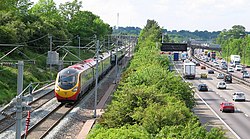
The historical geographic importance of the area led to many modern communication routes passing through this narrow gap: the coming of the railways brought the London and Birmingham Railway, now known as the West Coast Main Line; the most recent addition, in 1959, was the M1, Britain's first inter-urban motorway, bringing with it Watford Gap services, the first motorway service station.

Division

Geological divide

Topographically the gap is a pass caused by a tectonic plate shift[ citation needed ], between east and west hill ranges. A tributary of the River Nene rises at Watford and flows east to the Wash, whereas at Kilsby a tributary of the River Leam rises and flows west.

Sociological divide

Isogloss

Foot-strut split isogloss Foot-strut split.svg
Foot-strut split isogloss

In linguistics the Watford Gap is often regarded as where England experiences its division of north and south dialects. It is close to the north/south isogloss of the three key hallmarks of Northern English and Southern English: foot–strut split, bad-lad split and the Bath vowel.

North/South divide

Making use of the above linguistic divide, authors, journalists [1] [2] and social commentators have written and spoken of a north–south divide between Northern England and Southern England (although, in this context, the reference is sometimes assumed to be to the town of Watford in Hertfordshire, some 61 miles / 98 km to the southeast by road).

The expression "North of Watford" is used to mean the north of England, especially a place remote from London. [3] This is often taken to mean "North of Watford Gap" because of the Watford Gap services being a main stopping point on the M1 motorway. [4] However, the original expression was already in use many years before the Watford Gap Service Station or M1 opened in 1959. [5] [6] [7] It is unknown whether the original expression referred to Watford, Northamptonshire, or the much larger Watford in Hertfordshire, the last urban stop on one of the main railway lines from London to the north of England. There is evidence to support the latter, as the phrase "North of Watford Junction" was used with similar meaning in the past, referring to Watford Junction railway station at Watford, Hertfordshire. [8] [9] [10]

Stagecoach route

Historically, this was a junction of the West Midlands to London or East Anglia stagecoach routes across England. Its coaching inn, the Watford Gap, plied the passing trade of the area.

The pub, as well as the route from Cambridge to Coventry, is mentioned as early as 1769. [11] This route ran through Northampton, Duston, Harlestone, past Althorp Park, Brington, Long Buckby, Watford, Watford Gap itself—the map indicating that the coaching inn was on the west side of Watling Street, and then into Kilsby. The route from Watford Gap to Kilsby is now part of the diverted A5 road following construction of the M1 motorway.

The location of the Watford Gap coaching inn is the subject of confusion, with a location on the east side of the Grand Junction Canal (within the confines of the modern service station) being the most frequently cited, near the disused Welton railway station. There is no mention of a Watford Gap pub or any other pub at the suggested location on the 1889 or 1927 or 1952 Ordnance Survey maps of Northamptonshire. The nearest pub was the now-closed Stag's Head Inn in Station Road, Watford. The original location is further north on Watling Street. The canal-side building still stands but is closed for business and in poor repair.[ citation needed ] The earlier Watford Gap Inn is in good repair and generally unaltered, with the stabling yards and main structures used as farm buildings.

Motorway service station

The village is near to Watford Gap services on the M1 motorway, which was the first motorway service station in the United Kingdom.

Cultural references

Roy Harper's 1977 album Bullinamingvase contains a song titled "Watford Gap". Motorway service areas, which have since undergone radical innovations, were at the time in the United Kingdom typecast as spartan. The owners of Watford Gap services objected to his first reference to the place being ("Watford Gap, Watford Gap / A plate of grease and a load of crap…"). Harper was advised[ by whom? ] to drop the track from future UK copies of the album, though it reappeared on a CD reissue and remained on the American LP.[ citation needed ]

Related Research Articles

<span class="mw-page-title-main">Northamptonshire</span> County of England

Northamptonshire is a ceremonial county in the East Midlands of England. It is bordered by Leicestershire, Rutland and Lincolnshire to the north, Cambridgeshire to the east, Bedfordshire, Buckinghamshire, Oxfordshire to the south and Warwickshire to the west. Northampton is the largest settlement and the county town.

<span class="mw-page-title-main">Long Buckby</span> Human settlement in England

Long Buckby is a large village and civil parish in West Northamptonshire, England. In the 2021 census the parish of Long Buckby, which includes the hamlet of Long Buckby Wharf, was recorded as having a population of 4,511.

<span class="mw-page-title-main">Daventry</span> Market town and civil parish in Northamptonshire, England

Daventry is a market town and civil parish in the West Northamptonshire unitary authority area of Northamptonshire, England, close to the border with Warwickshire. At the 2021 Census, Daventry had a population of 28,123.

<span class="mw-page-title-main">A41 road</span> Road in England

The A41 is a trunk road between London and Liverpool, England. Now in parts replaced by motorways, it passes through or near Watford, Kings Langley, Hemel Hempstead, Aylesbury, Bicester, Solihull, Birmingham, West Bromwich, Wolverhampton, Newport, Whitchurch, Chester and Ellesmere Port.

<span class="mw-page-title-main">A5 road (Great Britain)</span> Major road in England and Wales

The A5, the London-Holyhead trunk road, is a major road in England and Wales. It runs for about 243 miles (391 km) from London to the Irish Sea at the ferry port of Holyhead. In many parts the route follows that of the Roman Iter II route which later took the Anglo-Saxon name Watling Street.

<span class="mw-page-title-main">A45 road</span> Major road in England

The A45 is a major road in England. It runs east from Birmingham past the National Exhibition Centre and the M42, then bypasses Coventry and Rugby, where it briefly merges with the M45 until it continues to Daventry. It then heads to Northampton and Wellingborough before running north of Rushden and Higham Ferrers and terminating at its junction with the A14 in Thrapston.

<span class="mw-page-title-main">A361 road</span> Longest three-digit road in England

The A361 is an A class road in southern England, which at 195 miles (314 km) is the longest three-digit A road in the UK.

The Grand Junction Canal is a canal in England from Braunston in Northamptonshire to the River Thames at Brentford, with a number of branches. The mainline was built between 1793 and 1805, to improve the route from the Midlands to London, by-passing the upper reaches of the River Thames near Oxford, thus shortening the journey.

<span class="mw-page-title-main">Barby, Northamptonshire</span> Village in Northamptonshire, England

Barby is a village and civil parish about 5 miles (8 km) north of Daventry in Northamptonshire, England. The 2011 Census recorded the parish population as 2,336. Barby is located right off the M45 motorway a short spur from the M1 motorway to the A45 Trunk Road.

<span class="mw-page-title-main">Watford, Northamptonshire</span> Village and civil parish in England

Watford is a village and civil parish in West Northamptonshire in England. At the time of the 2001 census, the parish's population was 224 people, including Murcott and increasing to 320 at the 2011 Census. Watford is home to Watford Gap services, the UK's oldest motorway service station, located directly on the M1 motorway and alongside the West Coast Main Line.

<span class="mw-page-title-main">Whilton Locks</span>

Whilton Locks is the name of a flight of seven locks on the Grand Union Canal near Daventry, in the county of Northamptonshire, England. They are also referred to as Buckby Lock Flight.

<span class="mw-page-title-main">Norton, Northamptonshire</span> Human settlement in England

Norton is a village in West Northamptonshire. The population including Brokhall and Norton at the 2011 census was 434. The village is about 2 miles (3.2 km) east of Daventry, 11 miles (18 km) west of Northampton. Junction 16 of the M1 motorway is about 7 miles (11 km) south-east and the nearest railway station is at Long Buckby 3 miles (5 km) to the east. Near the village, on Watling Street, is the Roman settlement of Bannaventa.

<span class="mw-page-title-main">Kilsby</span> Human settlement in England

Kilsby is a village and civil parish in West Northamptonshire, England. It is situated a short distance south of the border with Warwickshire approximately five miles southeast of Rugby. The parish of Kilsby, which includes Barby Nortoft, was estimated to have a population of 1,268 in 2020.

<span class="mw-page-title-main">Weedon Bec</span> Human settlement in England

Weedon Bec, usually just Weedon, is a village and parish in West Northamptonshire, England. It is close to the source of the River Nene. The population of the civil parish at the 2011 census was 2,706.

<span class="mw-page-title-main">Welton, Northamptonshire</span> Human settlement in England

Welton is a village and civil parish in the county of Northamptonshire, England. The village is located 3 miles (4.8 km) north of the nearest town Daventry. It is 13 miles (21 km) west-north west of Northampton and 9 miles (14 km) south east of Rugby. The village is 1 mile (1.6 km) off the A361 that runs between Daventry and Crick where the A5 and the M1 junction 18 gives access to the national motorway network north and south.

<span class="mw-page-title-main">Northampton loop</span>

The Northampton loop is a railway line serving the town of Northampton. It is a branch of the West Coast Main Line, deviating from the faster direct main line which runs to the west. The WCML is a four track line up to either end of the Loop: the 'up' and 'down' fast tracks take the direct route while the 'up' and 'down' slow tracks are diverted via Northampton railway station. Generally, fast express trains run via the direct line, while freight and slower passenger services run via the loop line.

<span class="mw-page-title-main">Long Buckby railway station</span> Railway station in Northamptonshire, England

Long Buckby railway station is a small railway station next to the village of Long Buckby, Northamptonshire, England. It is the nearest railway station for the larger town of Daventry, 4 miles (6.4 km) away.

<span class="mw-page-title-main">Watford Gap services</span> Motorway services in Northamptonshire, England

Watford Gap services are motorway services on the M1 motorway in Northamptonshire, England. They opened on 2 November 1959, the same day as the M1, making them one of the oldest motorway services in Britain. The facilities were originally managed by Blue Boar, a local company that had run a nearby petrol station before the M1 opened. Roadchef bought the services from Blue Boar in 1995.

<span class="mw-page-title-main">Blisworth</span> Human settlement in England

Blisworth is a village and civil parish in the West Northamptonshire, England. The West Coast Main Line, from London Euston to Manchester and Scotland, runs alongside the village partly hidden and partly on an embankment. The Grand Union Canal passes through the village and the north portal of the Blisworth tunnel is near Stoke Road.

<span class="mw-page-title-main">Welton railway station</span> Former railway station in Northamptonshire, England

Welton was a railway station on the West Coast Main Line serving the villages of Welton and Watford in Northamptonshire. The station was opened in 1838 as part of the London and Birmingham Railway. It was located closer to Watford than to Welton, however it was named after the latter in order to avoid confusion with the much larger town of Watford further south. The station had an unusual arrangement of staggered platforms, one platform on each side of the road bridge. This was because of the confined site, being hemmed in by the Grand Union Canal and A5 road.

References

  1. Jennings, Charles (26 February 2008). "Why the Watford Gap will never be Bridged". The Daily Telegraph. London. Retrieved 8 July 2013.
  2. Nugent, Helen (5 July 2013). "Northern Soul: my antidote to Fleet Street's abandonment of the North". The Guardian. London. Retrieved 8 July 2013.
  3. Longman Dictionary
  4. Robshaw, Brandon (7 August 2017). "North of Watford Gap" via WordPress.
  5. Manchester Evening News , 23 May 1949
  6. Staffordshire Sentinel , 7 November 1950
  7. Birmingham Daily Gazette , 4 February 1953
  8. Birmingham Daily Post, 8 May 1967
  9. Birmingham Daily Post, 29 December 1970
  10. Liverpool Echo, 1 January 1972
  11. "unimag_cam-cov-roads_1769". freepages.rootsweb.com.

52°18′22″N1°07′26″W / 52.306°N 1.124°W / 52.306; -1.124