
The Baltimore–Washington Parkway is a highway in the U.S. state of Maryland, running southwest from Baltimore to Washington, D.C. The road begins at an interchange with U.S. Route 50 (US 50) near Cheverly in Prince George's County at the Washington, D.C. border, and continues northeast as a parkway maintained by the National Park Service (NPS) to MD 175 near Fort Meade, serving many federal institutions. This portion of the parkway is dedicated to Gladys Noon Spellman, a representative of Maryland's 5th congressional district, and has the unsigned Maryland Route 295 (MD 295) designation. Commercial vehicles, including trucks, are prohibited within this stretch. This section is administered by the NPS's Greenbelt Park unit. After leaving park service boundaries the highway is maintained by the state and signed with the MD 295 designation. This section of the parkway passes near Baltimore–Washington International Thurgood Marshall Airport. Upon entering Baltimore, the Baltimore Department of Transportation takes over maintenance of the road and it continues north to an interchange with Interstate 95 (I-95). Here, the Baltimore–Washington Parkway ends and MD 295 continues north unsigned on Russell Street, which carries the route north into downtown Baltimore. In downtown Baltimore, MD 295 follows Paca Street northbound and Greene Street southbound before ending at US 40.

Federal Hill is a neighborhood in Baltimore, Maryland, United States that lies just to the south of the city's central business district. Many of the structures are included in the Federal Hill Historic District, listed on the National Register of Historic Places in 1970. Other structures are included in the Federal Hill South Historic District, listed in 2003.

Charles Village is a neighborhood located in the north-central area of Baltimore, Maryland, USA. It is a diverse, eclectic, international, largely middle-class area with many single-family homes that is in proximity to many of Baltimore's cultural amenities. Nearby are the Baltimore Museum of Art, The Homewood campus of The Johns Hopkins University, Olmstead's Wyman Park, and the weekly Waverly Farmers Market, and the arts district, Station North. Homes are exemplary Baltimore brick and stone row houses, many dating from the 1890s. Running from downtown north is the historic boulevard, Charles Street, where Baltimore's Easter Promenade once took place.

Canton is a historic waterfront neighborhood in Baltimore, Maryland, United States. The neighborhood is along Baltimore's outer harbor in the southeastern section of the city, roughly two miles east of Baltimore's downtown district and next to or near the neighborhoods of Patterson Park, Fell's Point, Highlandtown, and Brewers Hill.

Bolton Hill is a neighborhood in Baltimore, Maryland, with 20 blocks of mostly preserved buildings from the late 19th century. It is listed on the National Register of Historic Places, preserved as a Baltimore City Historic District, and included within the boundaries of Baltimore National Heritage Area. The neighborhood is bounded by North Avenue, Mount Royal Avenue, Cathedral Street, Dolphin Street, and Eutaw Place. Bolton Hill is a largely residential neighborhood with three-story row houses with red brick, white marble steps, and high ceilings. There are also larger more ornate originally single-family houses, many houses of worship, parks, monuments, and a few large apartment buildings. Many significant residents have lived in the neighborhood, including F. Scott Fitzgerald, Woodrow Wilson, the Cone sisters, and Florence Rena Sabin.

Abell is a neighborhood located in the north-central area of Baltimore, Maryland, United States. It is considered to be part of Charles Village, Baltimore.

Highlandtown is a neighborhood of Baltimore, Maryland, United States.
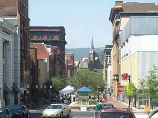
The Downtown Cumberland Historic District, also referred to as the Downtown Cumberland Mall, is the main shopping and dining district for the city of Cumberland, Maryland.

Waverly is a neighborhood in the north central area of Baltimore, Maryland, located to the north of the adjacent same neighborhood called Better Waverly and west of Ednor Gardens-Lakeside, north and east of Charles Village west of the area of Coldstream-Homestead-Montebello neighborhoods, along with the campus of the former red brick 'H'-shaped building for Eastern High School (1938–1984), facing north towards 33rd Street, now renovated since the 1990s into offices for The Johns Hopkins University, a mile to the west. Adjacent to the east of the Eastern High/Johns Hopkins campus is the landmark tree-shaded campus of The Baltimore City College, at 33rd Street and The Alameda. The College is a massive stone structure with a 150-foot bell tower visible for miles, nicknamed "The Castle on the Hill", constructed 1926–1928 of Collegiate Gothic architecture on one of the highest hills in the city, "Collegian Hill", with the downtown skyline visible to the south. City College is the third oldest public high school in America, founded 1839 in downtown has been through eight different sites in its 179 years of history and five major buildings, each were architectural landmarks in their times. From its beginnings, until 1979, it was a single sex secondary school for boys in the Baltimore City Public Schools, when it co-educated admitting young women. These three major institutions and their sports events dominated the east side of Waverly/Better Waverly for nine decades.

Lauraville is a neighborhood in northeast Baltimore, Maryland. The neighborhood is bounded on the east by Harford Road, on the north by Echodale Avenue, on the south by Argonne Drive and Herring Run Park, and on the west side by Morgan Park and Morgan State University, with East Cold Spring Lane passing through the center of Lauraville.

Seton Hill Historic District is a historic district in Baltimore, Maryland. It was listed on the National Register of Historic Places in 1975.
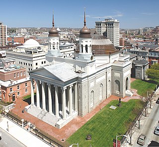
The Cathedral Hill Historic District is an area in Baltimore, Maryland. It lies in the northern part of Downtown just south of Mount Vernon. Roughly bounded by Saratoga Street, Park Avenue, Hamilton Street, and St. Paul Street, these 10 or so blocks contain some of the most significant buildings in Baltimore. The area takes its name from the Basilica of the Assumption which sits in the heart of the district. Despite the number of large religious structures in the area, the district's buildings are primarily commercial in character, with a broad collection of significant commercial structures ranging in date from 1790 to 1940.

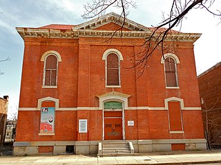
Leadenhall Street Baptist Church is a historic Baptist church located at Baltimore, Maryland, United States. It is a gable-front rectangular brick temple with simple Renaissance Revival detail. The original exterior wall surfaces have been covered with formstone on the main façade and stucco elsewhere. It features round-arched stained glass windows on each side bay. It was built in 1873, by Joseph Thomas & Son for the city's African American Baptists who were then centered in the old southwest area from the downtown business district of Baltimore in the "Sharp-Leadenhall" community in the old "South Baltimore" area. Nearby is its now famed revitalized "Inner Harbor" area of the old "Basin" for the harbor port.
Franklin Square Historic District is a national historic district in Baltimore, Maryland, United States. It is a 19th-century rowhouse neighborhood developed along a strict grid street pattern. A one square block, two and a half acre public park, Franklin Square, is a focal point for the area and the most elaborate rowhousing surrounds the square. The district contains approximately 1,300 buildings of which approximately 1,250 contribute to the significance of the historic district.
Old West Baltimore Historic District is a national historic district in Baltimore, Maryland, United States. It is primarily a row house neighborhood of approximately 175 city blocks directly northwest of downtown Baltimore. The district includes other housing from grand mansions to alley houses, as well as churches, public buildings, commercial buildings, and landscaped squares. Pennsylvania Avenue, the main street of the community, features a later 20th century municipal market house. Within the district are civic monuments that relate to Baltimore's premier historic African-American community. Such noteworthy figures as Supreme Court Justice Thurgood Marshall, Congressman Parren Mitchell, jazz artist Cab Calloway, civil rights leader Lillie Mae Carroll Jackson, and Carl Murphy, editor of the Baltimore Afro-American newspaper, lived and / or worked in the area.

Baltimore East/South Clifton Park Historic District is a national historic district in Baltimore, Maryland, United States. It is primarily an urban residential area organized in a gridiron pattern. It comprises approximately 110 whole and partial blocks that formed the historic northeast corner of the City of Baltimore prior to 1888. While rowhouses dominate the urban area, the historic district also contains other property types which contribute to its character including brewing, meat packing, cigar manufacturing, printing, and a tobacco warehouse. The Baltimore Cemetery completes the historic district.

The Cypress–Emerson Historic District encompasses a residential area on the west side of Brookline Village in Brookline, Massachusetts, United States. Centered on Waverly and Cypress Streets, and including Emerson Park, this area was developed in the post-Civil War era, its growth matching that of the commercial areas of the village. The district was listed on the National Register of Historic Places in 1985.

East Monument Historic District or Little Bohemia, is a national historic district in Baltimore, Maryland. It is a large residential area with a commercial strip along East Monument Street. It comprises approximately 88 whole and partial blocks. The residential area is composed primarily of rowhomes that were developed, beginning in the 1870s, as housing for Baltimore's growing Bohemian (Czech) immigrant community. During the late 19th and early 20th centuries the neighborhood was the heart of the Bohemian community in Baltimore. The Bohemian National Parish of the Roman Catholic Church, St. Wenceslaus, is located in the neighborhood. The historic district includes all of McElderry Park and Milton-Montford, most of Middle East and Madison-Eastend, and parts of Ellwood Park.
Better Waverly is a neighborhood in the North District of Baltimore, located between the neighborhoods of Charles Village (west) and Coldstream-Homestead-Montebello (east). Its boundaries are marked by East 33rd Street (north), Exeter Hall Avenue (south), Greenmount Avenue (west) and Loch Raven Road (east).

Midtown-Edmondson is a mixed-use neighborhood in western Baltimore City developed mostly between the 1880s and the 1910s. The neighborhood is mainly composed of residential rowhouses, with a mixed-used business district along Edmondson Avenue, and industrial warehouses and buildings dotted along the CSX railroads that bound its western edge.


