Related Research Articles

Banff National Park is Canada's oldest national park, established in 1885. Located in Alberta's Rocky Mountains, 110–180 kilometres (68–112 mi) west of Calgary, Banff encompasses 6,641 square kilometres (2,564 sq mi) of mountainous terrain, with many glaciers and ice fields, dense coniferous forest, and alpine landscapes. The Icefields Parkway extends from Lake Louise, connecting to Jasper National Park in the north. Provincial forests and Yoho National Park are neighbours to the west, while Kootenay National Park is located to the south and Kananaskis Country to the southeast. The main commercial centre of the park is the town of Banff, in the Bow River valley.

Medicine Hat is a city in southeast Alberta, Canada. It is located along the South Saskatchewan River. It is approximately 169 km (105 mi) east of Lethbridge and 295 km (183 mi) southeast of Calgary. This city and the adjacent Town of Redcliff to the northwest are within Cypress County. Medicine Hat was the sixth-largest city in Alberta in 2016 with a population of 63,230.

Elk Island National Park is a national park in Alberta, Canada, that played an important part in the conservation of the Plains bison. The park is administered by the Parks Canada Agency. This "island of conservation" is 35 km (22 mi) east of Edmonton, along the Yellowhead Highway, which goes through the park. It is Canada's eighth smallest in area but largest fully enclosed national park, with an area of 194 km2 (75 sq mi).

Wood Buffalo National Park is the largest national park of Canada at 44,807 km2 (17,300 sq mi). It is located in northeastern Alberta and the southern Northwest Territories. Larger in area than Switzerland, it is the second-largest national park in the world. The park was established in 1922 to protect the world's largest herd of free-roaming wood bison. They became hybridized after the introduction of plains bison. The population is currently estimated at about 3,000. It is one of two known nesting sites of whooping cranes.

Grasslands National Park is a Canadian national park located near the village of Val Marie, Saskatchewan, and one of 44 national parks and park reserves in Canada's national park system. This national park is north from the American state of Montana and lies adjacent to the international boundary.

The Peace–Athabasca Delta, located in northeast Alberta, is the largest freshwater inland river delta in North America. It is located partially within the southeast corner of Wood Buffalo National Park, Canada's largest national park, and also spreads into the Regional Municipality of Wood Buffalo, west and south of the historical community of Fort Chipewyan. The delta encompasses approximately 321,200 ha, formed where the Peace and Athabasca rivers converge on the Slave River and Lake Athabasca. The delta region is designated a wetland of international importance and a UNESCO World Heritage Site. The region is large enough that it is considered one of twenty distinct natural subregions of Alberta by the provincial government's Natural Regions Committee.

Val Marie is a village in the Canadian province of Saskatchewan within the Rural Municipality of Val Marie No. 17 and Census Division 4. It is about 30 kilometres from the Canada-United States border.

Antelope Island, with an area of 42 square miles (109 km2), is the largest of ten islands located within the Great Salt Lake in the US state of Utah. The island lies in the southeastern portion of the lake, near Salt Lake City and Davis County, and becomes a peninsula when the lake is at extremely low levels. It is protected as Antelope Island State Park.

James B. Harkin, also known as the Father of National Parks, was a Canadian-born journalist turned bureaucrat with a passion for conservation but also widely renowned for his commodification of the Canadian landscape. Harkin began his career as a journalist under the umbrella of the Ottawa Journal and Montreal Herald, two conservative newspapers at the time, but soon through his persistence and prowess gained entry into civil service during his mid-twenties. Under the tutelage of some influential figures working for the Liberal Party of Canada, most notably Clifford Sifton and Frank Oliver, Harkin was able to acquire an appointment to be the first commissioner of the Dominion Parks Branch in 1911. During his career, Harkin oversaw the establishment of national parks that include Elk Island, Mount Revelstoke, Point Pelee, Kootenay, Wood Buffalo, Prince Albert, Riding Mountain, Georgian Bay Islands and Cape Breton Highlands.
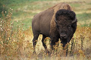
The Plains bison is one of two subspecies/ecotypes of the American bison, the other being the wood bison. A natural population of Plains bison survives in Yellowstone National Park and multiple smaller reintroduced herds of bison in many places in the United States as well as southern portions of the Canadian Prairies.

Buffalo National Park was created near the town of Wainwright in east central Alberta on June 5, 1909. It was closed in 1940 and delisted in 1947 when the land was transferred to the Department of National Defence. The 583 km2 (225 sq mi) park land was developed for use by Canadian Forces Base Wainwright and comprises the majority of its space. The first Park Warden was Bud Cotton, who served from 1912 through 1940.

The Rural Municipality of Antelope Park No. 322 is a rural municipality (RM) in the Canadian province of Saskatchewan within Census Division No. 13 and SARM Division No. 6. It is located along the border with Alberta.
Menissawok National Park was a national park established in 1922 southeast of the town of Maple Creek, Saskatchewan, in the southwest part of the Canadian province. It closed in 1930, and was delisted in 1947. The 44 km2 (17 sq mi) park land had functioned as a pronghorn reserve beginning in 1914.

The Fauna of Saskatchewan include several diverse land and aquatic animal species. From the multiplicity of invertebrates and vertebrates, two have been chosen as symbols of Saskatchewan. Cenozoic vertebrate fossils reveal the geological evolution of the interior plains and its prehistoric biogeography. Today, Saskatchewan's ecosystems range from the sub-arctic tundra of the Canadian Shield in north Saskatchewan to aspen parkland, the Mid-Continental Canadian forests in the centre of the province and grassland prairie. Fauna inhabit areas unique to their own specific and varied breeding, foraging and nesting requirements. With a large land and water area, and small population density, the ecoregions of Saskatchewan provide important habitat for many animals, both endangered and not. Naturalists observing wildlife have enumerated shrinking and growing wildlife populations. They advocate programs and methods to preserve or re-introduce endangered species and identify programs of control for outbreaks of wildlife populations. A broad diversity of wildlife habitats are preserved as parks and reserves protecting the feeding and breeding grounds of protected and indigenous fauna of Saskatchewan.
The Mid-Continental Canadian forests are a taiga ecoregion of Western Canada, as defined by the World Wildlife Fund (WWF) categorization system.
Nemiskam National Park was created north of the community of Nemiskam in south central Alberta, Canada, in 1922. The park was closed and delisted in 1947. The first Park Superintendent was Edgar McHugh. Nemiskam is a First Nations word meaning "between two valleys", referring to the Chin Coulee and Etzikom Coulee on either side of the former community.

The Northern Mixed Grasslands is one of 867 terrestrial ecoregions defined by the World Wide Fund for Nature. This ecoregion includes parts of the Canadian provinces of Alberta, Saskatchewan, and Manitoba, north-central and eastern North Dakota, most of east South Dakota, and north-central Nebraska in the American Great Plains. The United States Environmental Protection Agency (EPA) defines this ecoregion as the Northern Glaciated Plains.
Last Mountain Lake Bird Sanctuary is a National Historic Site of Canada, located in the rural municipality of Last Mountain Valley No. 250 in Saskatchewan. The migratory bird sanctuary was the first established in North America. The 47.36-square-kilometre (18.29 sq mi) area is within the Last Mountain Lake National Wildlife Area, an International Biological Program site, and includes adjacent uplands.
References
Citations
- ↑ Wyatt et al. 1937, p. 3.
- 1 2 3 Lothian 1987, subsection Antelope Parks Established.
- ↑ Lothian 1987, subsection Nemiskam Park Abolished.
- ↑ Trottier 2008.
- ↑ Jardine 2008.
- ↑ Lothian 1987, subsection Abolition of Park Proposed.
Bibliography
- Jardine, Helen (March 7, 2008). "Natural gas or natural grass". Capital News Online. Ottawa, Canada. Archived from the original on 2008-03-07. Retrieved 2010-12-23.
- Lothian, W.F. (1987). "Chapter 7: Preserving Canada's Wildlife". A History of Canada's National Parks. IV. Ottawa, Canada: Parks Canada. ISBN 0-662-11497-3.
- Lothian, W.F. (1987a). "National Parks Established for the Protection of American Bison and Pronghorn Antelope" (PDF) (Map). A History of Canada's National Parks. Ottawa, Canada: Parks Canada. IV. ISBN 0-662-11497-3.
- Trottier, Garry (February 18, 2008). Submission to the Joint Review Panel: EnCana Shallow Gas Infill Development in the Suffield National Wildlife Area (NWA) (PDF) (Report). Retrieved 2010-12-23.
- Wyatt, F. A.; Newton, J. D.; Bower, W. E.; Odynsky, W. (August 1937). Soil Survey of Rainy Hills Sheet (PDF) (Report). Edmonton, Canada: College of Agriculture, University of Alberta. Retrieved 2010-12-23.