An editor has nominated this article for deletion. You are welcome to participate in the deletion discussion , which will decide whether or not to retain it. |
The following is a list of documented weather events, sorted by year and by type. It includes tropical cyclones, tornadoes, windstorms, and snowstorms.
| Year | Tropical cyclones | Tornadoes [nb 1] | European windstorms | Snowstorms | Total | Refs |
|---|---|---|---|---|---|---|
| 1946 | ||||||
| 1997 | 108 | 1,148 | 1 [1] | 2 | 1,259 | |
| 1998 | 125 | 1,424 | 3 [2] | 1 | 1,553 | |
| 1999 | 142 | 1,426 | 3 | 2 | 1,573 | [3] |
| 2000 | 140 | 1,075 | 1 [4] | 2 | 1,218 | [5] |
| 2001 | 128 | 1,215 | 1 | 0 | 1,334 | [6] |
| 2002 | 123 | 934 | 1 | 3 | 1,061 | [7] |
| 2003 | 129 | 1,374 | 0 | 2 | 1,505 | [8] |
| 2004 | 132 | 1,817 | 2 | 2 | 1,953 | [9] |
| 2005 | 141 | 1,265 | 2 [10] | 2 | 1,410 | [11] |
| 2006 | 134 [nb 2] | 1,103 | 2 | 5 | 1,244 | [12] |
| 2007 | 130 | 1,096 | 5 | 6 | 1,137 | [13] |
| 2008 | 124 | 1,692 | 2 | 4 | 1,822 | [14] |
| 2009 | 130 | 1,159 | 2 | 2 | 1,293 | [15] |
| 2010 | 111 | 1,282 | 2 | 7 | 1,402 | |
| 2011 | 131 | 1,703 | 7 | 8 | 1,849 | |
| 2012 | 128 | 929 | 1 | 4 | 1,062 | |
| 2013 | 139 | 903 | 7 | 9 | 1,058 | |
| 2014 | 117 | 928 | 16 | 12 | 1,073 | |
| 2015 | 134 | 1,178 | 11 | 10 | 1,333 | |
| 2016 | 140 | 976 | 8 | 12 | 1,136 | |
| 2017 | 146 | 1,428 | 9 [nb 3] | 9 | 1,592 | |
| 2018 | 151 | 1,123 | 20 [nb 4] | 13 | 1,307 | |
| 2019 | 150 | 1,520 | 18 [nb 5] | 8 | 1,696 | |
| 2020 | 141 | 1,050 | 21 | 13 | 1,225 | |
| 2021 | 145 [nb 6] | 1,280 | 16 [nb 7] | 17 | 1,358 | |
| 2022 | 132 | 1,133 | 47 [nb 8] | 18 | 1,424 | |
| 2023 | 10 | 123 | 3 | 2 | 138 | |
| Total [nb 9] | 3,460 [16] | 31,240 | 211 [nb 10] | 169 [nb 11] | 34,985 | [17] |

In meteorology, a cyclone is a large air mass that rotates around a strong center of low atmospheric pressure, counterclockwise in the Northern Hemisphere and clockwise in the Southern Hemisphere as viewed from above. Cyclones are characterized by inward-spiraling winds that rotate about a zone of low pressure. The largest low-pressure systems are polar vortices and extratropical cyclones of the largest scale. Warm-core cyclones such as tropical cyclones and subtropical cyclones also lie within the synoptic scale. Mesocyclones, tornadoes, and dust devils lie within the smaller mesoscale.
A storm is any disturbed state of the natural environment or the atmosphere of an astronomical body. It may be marked by significant disruptions to normal conditions such as strong wind, tornadoes, hail, thunder and lightning, heavy precipitation, heavy freezing rain, strong winds, wind transporting some substance through the atmosphere such as in a dust storm, among other forms of severe weather.
These are some notable tornadoes, tornado outbreaks, and tornado outbreak sequences that have occurred around the globe.
The 1978 Atlantic hurricane season was a slightly above average hurricane season in terms of number of named storms. Eleven tropical cyclones were named in all, and five of these became hurricanes; two of the five became a major hurricane. This was also the last Atlantic hurricane season to use an all-female naming list. The season officially began on June 1, 1978, and ended on November 30, 1978. These dates, adopted by convention, denote the period in each year when most tropical cyclogenesis occurs in the Atlantic basin. However, the formation of subtropical or tropical cyclones is possible at any time of the year, as shown by the formation of an unnamed subtropical storm on January 18.

The 1982 Atlantic hurricane season was an extremely inactive Atlantic hurricane season with five named tropical storms and one subtropical storm. Two storms became hurricanes, one of which reached major hurricane status. The season officially began on June 1, 1982, and lasted until November 30, 1982. These dates conventionally delimit the period of each year when most tropical cyclones form in the Atlantic basin. Activity started early with Hurricane Alberto forming on the first day of the season. Alberto threatened the Southwestern Florida coast as a tropical storm, meadering offshore in the southeastern Gulf of Mexico and causing 23 fatalities in Cuba. The next system, a subtropical storm, formed later in June and affected the same area as Alberto, causing $10 million in damage.
This is a list of meteorology topics. The terms relate to meteorology, the interdisciplinary scientific study of the atmosphere that focuses on weather processes and forecasting.

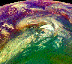
The eye is a region of mostly calm weather at the center of a tropical cyclone. The eye of a storm is a roughly circular area, typically 30–65 kilometers in diameter. It is surrounded by the eyewall, a ring of towering thunderstorms where the most severe weather and highest winds of the cyclone occur. The cyclone's lowest barometric pressure occurs in the eye and can be as much as 15 percent lower than the pressure outside the storm.

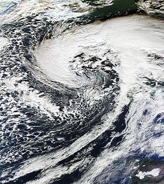
Extratropical cyclones, sometimes called mid-latitude cyclones or wave cyclones, are low-pressure areas which, along with the anticyclones of high-pressure areas, drive the weather over much of the Earth. Extratropical cyclones are capable of producing anything from cloudiness and mild showers to severe gales, thunderstorms, blizzards, and tornadoes. These types of cyclones are defined as large scale (synoptic) low pressure weather systems that occur in the middle latitudes of the Earth. In contrast with tropical cyclones, extratropical cyclones produce rapid changes in temperature and dew point along broad lines, called weather fronts, about the center of the cyclone.

Severe weather is any dangerous meteorological phenomenon with the potential to cause damage, serious social disruption, or loss of human life. These vary depending on the latitude, altitude, topography, and atmospheric conditions. High winds, hail, excessive precipitation, and wildfires are forms and effects, as are thunderstorms, downbursts, tornadoes, waterspouts, tropical cyclones, and extratropical cyclones. Regional and seasonal phenomena include blizzards (snowstorms), ice storms, and duststorms.

Tropical Depression Ten was a short-lived tropical cyclone that made landfall on the Florida Panhandle in September 2007. The system developed as a subtropical depression on September 21 in the northeastern Gulf of Mexico from the interaction of a tropical wave, the tail end of a cold front, and an upper-level low. Initially containing a poorly defined circulation and intermittent thunderstorm activity, the system transitioned into a tropical depression after convection increased over the center. Tracking northwestward, the depression moved ashore near Fort Walton Beach early on September 22 and dissipated over southeastern Alabama shortly thereafter.
European windstorms are powerful extratropical cyclones which form as cyclonic windstorms associated with areas of low atmospheric pressure. They can occur throughout the year, but are most frequent between October and March, with peak intensity in the winter months. Deep areas of low pressure are common over the North Atlantic, and occasionally start as nor'easters off the New England coast. They frequently track across the North Atlantic Ocean towards the north of Scotland and into the Norwegian Sea, which generally minimizes the impact to inland areas; however, if the track is further south, it may cause adverse weather conditions across Central Europe, Northern Europe and especially Western Europe. The countries most commonly affected include the United Kingdom, Ireland, the Netherlands, Norway, Germany, the Faroe Islands and Iceland.

Throughout 2006, 133 tropical cyclones formed in seven bodies of water known as tropical cyclone basins. Of these, 80 have been named, including two tropical cyclones in the South Atlantic Ocean, and a tropical cyclone in the Mediterranean Sea, by various weather agencies when they attained maximum sustained winds of 65 km/h (40 mph). The strongest storms of the year were Typhoon Yagi in the Western Pacific, and Cyclone Glenda of the Australian region. The deadliest and costliest storms of the year were a series of five typhoons that struck the Philippines and China; Chanchu, Bilis, Saomai, Xangsane, and Durian, with most of the damage being caused by Durian of November. So far, 27 Category 3 tropical cyclones formed, including five Category 5 tropical cyclones in the year. The accumulated cyclone energy (ACE) index for the 2006, as calculated by Colorado State University was 761 units.
Storm Abigail was an extratropical cyclone that brought high winds, rain, lightning, and snow across northern Scotland. The first named storm, it is the first ever storm to be officially named by the Met Office of the United Kingdom and Met Éireann of the Republic of Ireland, on 10 November 2015.

Weather system naming in Europe follows several multinational schemes under the EUMETNET framework. On the north Atlantic coast, the United Kingdom's Met Office, in collaboration with its Irish counterpart Met Éireann and, since 2019, its Dutch counterpart the Royal Netherlands Meteorological Institute (KNMI), decided to introduce a storm naming system following the St Jude's day storm on 27–28 October 2013 which caused 17 deaths in Europe and the 2013–14 Atlantic winter storms in Europe to give a single, authoritative naming system to prevent confusion with the media and public using different names for the same storms. The first European windstorm to be named was Abigail on 10 November 2015. The definitive list is combined from suggestions from the three countries.

The year 1992 featured the highest amount of accumulated cyclone energy (ACE) on record, with an ACE rating of 1,163.1 units. It would be regarded as one of the most intense tropical cyclone years on record. Throughout the year, 111 tropical cyclones formed, of which 101 were given names by various weather agencies. Five Category 5 tropical cyclones would form in 1992.