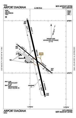
Bert Mooney Airport is a public airport three miles southeast of Butte, in Silver Bow County, Montana, United States. It is owned by the Bert Mooney Airport Authority.
Chadron Municipal Airport is in Dawes County, Nebraska, United States, five miles west of Chadron. It sees one airline, Southern Airways Express, subsidized by the Essential Air Service program.

Range Regional Airport is a public use airport located four nautical miles southeast of the central business district of Hibbing, in Saint Louis County, Minnesota, United States. It was formerly known as Chisholm-Hibbing Airport or Chisholm-Hibbing Municipal Airport. The airport is mostly used for general aviation but is also served by one commercial and one charter airline. Scheduled passenger service is subsidized by the Essential Air Service program.
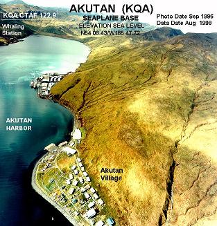
Akutan Seaplane Base is a public use seaplane base located in Akutan, a city on Akutan Island in the Aleutians East Borough of the U.S. state of Alaska. Scheduled seaplane service was subsidized by the Essential Air Service program until late 2012 when PenAir retired their Grumman Goose amphibious aircraft and a new land-based airport on neighboring Akun Island was built. The new airport is known as Akutan Airport.

King Salmon Airport is a state-owned public-use airport located just southeast of King Salmon, in the Bristol Bay Borough of the U.S. state of Alaska. It was formerly the Naknek Air Force Base, named for its location near the Naknek River.

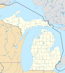
Charlevoix Municipal Airport is a city-owned, public-use airport located one nautical mile (2 km) southwest of the central business district of Charlevoix, a city in Charlevoix County, Michigan, United States. It is mostly used for general aviation, but also offers passenger service to Beaver Island via Island Airways and Fresh Air Aviation.
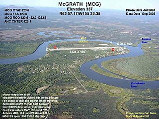
McGrath Airport is a state-owned public-use airport serving McGrath, a city in the Yukon-Koyukuk Census Area of the U.S. state of Alaska.

Ralph M. Calhoun Memorial Airport is a state-owned public-use airport located one nautical mile (1.85 km) west of the central business district of Tanana, a city in the Yukon-Koyukuk Census Area of the U.S. state of Alaska.
Beaver Island Airport is a public use airport located on Beaver Island in Charlevoix County, Michigan, United States. It is owned by St. James Township and Peaine Township. It is included in the Federal Aviation Administration (FAA) National Plan of Integrated Airport Systems for 2017–2021, in which it is categorized as a local general aviation facility.
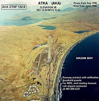
Atka Airport is a state-owned, public use airport located two nautical miles (4 km) north of the central business district of Atka, a city on Atka Island in the U.S. state of Alaska. Scheduled commercial airline passenger service is subsidized by the Essential Air Service program.

Ketchikan Harbor Seaplane Base is a privately owned, public use seaplane base located at the harbor of Ketchikan, a city in the Ketchikan Gateway Borough of the U.S. state of Alaska. It is located near the Ketchikan International Airport, which also has its own seaplane landing area. Prior to the opening of the Ketchikan International Airport in 1973, scheduled passenger seaplane service was operated with amphibian aircraft between the seaplane base and the Annette Island Airport located approximately 20 miles south, as this land plane airfield previously served as the primary airport for Ketchikan, with scheduled airline flights being operated by Pan American World Airways, Pacific Northern Airlines and Western Airlines into Annette Island over the years.
St. George Airport is a state-owned public-use airport located four nautical miles of the central business district of St. George, a city on St. George Island in the Aleutians West Census Area of the U.S. state of Alaska. Scheduled passenger airline service is provided by Grant Aviation.
Metlakatla Seaplane Base is a state owned, public use seaplane base located in Metlakatla, a community on Annette Island in the Prince of Wales-Hyder Census Area of the U.S. state of Alaska.
Old Harbor Airport is a state owned, public use airport located two nautical miles (4 km) northeast of the central business district of Old Harbor, a city in the Kodiak Island Borough in the U.S. state of Alaska.
Sand Point Airport is a state owned, public use airport located two nautical miles (4 km) southwest of the central business district of Sand Point, a city in the Aleutians East Borough in the U.S. state of Alaska. Scheduled airline service to Anchorage International Airport is provided by Peninsula Airways (PenAir).
Ouzinkie Airport is a state-owned public-use airport serving Ouzinkie, a city on Spruce Island in the Kodiak Island Borough of the U.S. state of Alaska.
Thorne Bay Seaplane Base is a state-owned public-use seaplane base serving Thorne Bay, a community in the Prince of Wales-Hyder Census Area of the U.S. state of Alaska.
Port Lions Airport is a state-owned, public-use airport located two nautical miles northeast of the central business district of Port Lions, a city located on Kodiak Island in the Kodiak Island Borough of the U.S. state of Alaska.
Delta Junction Airport is a public use airport located in and owned by Delta Junction, a city in the Southeast Fairbanks Census Area of the U.S. state of Alaska.

Hollis Clark Bay Seaplane Base is a state owned, public use seaplane base located one nautical mile (2 km) northeast of the central business district of Hollis, a community in the Prince of Wales-Hyder Census Area in the U.S. state of Alaska. It was formerly known as Hollis Seaplane Base.