Related Research Articles

The Acadian orogeny is a long-lasting mountain building event which began in the Middle Devonian, reaching a climax in the early Late Devonian. It was active for approximately 50 million years, beginning roughly around 375 million years ago, with deformational, plutonic, and metamorphic events extending into the Early Mississippian. The Acadian orogeny is the third of the four orogenies that created the Appalachian orogen and subsequent basin. The preceding orogenies consisted of the Potomac and Taconic orogeny, which followed a rift/drift stage in the Late Neoproterozoic. The Acadian orogeny involved the collision of a series of Avalonian continental fragments with the Laurasian continent. Geographically, the Acadian orogeny extended from the Canadian Maritime provinces migrating in a southwesterly direction toward Alabama. However, the Northern Appalachian region, from New England northeastward into Gaspé region of Canada, was the most greatly affected region by the collision.

The Taconic orogeny was a mountain building period that ended 440 million years ago and affected most of modern-day New England. A great mountain chain formed from eastern Canada down through what is now the Piedmont of the East coast of the United States. As the mountain chain eroded in the Silurian and Devonian periods, sediments from the mountain chain spread throughout the present-day Appalachians and midcontinental North America.

The geology of Australia includes virtually all known rock types, spanning a geological time period of over 3.8 billion years, including some of the oldest rocks on earth. Australia is a continent situated on the Indo-Australian Plate.

South Wales is an area with many features of outstanding interest to geologists, who have for long used the area for University field trips.
The Windermere Supergroup is a geological unit formed during the Ordovician to Silurian periods ~450 million years ago, and exposed in northwest England, including the Pennines and correlates along its strike, in the Isle of Man and Ireland, and down-dip in the Southern Uplands and Welsh Borderlands. It underlies much of north England's younger cover, extending south to East Anglia. It formed as a foreland basin, in a similar setting to the modern Ganges basin, fronting the continent of Avalonia as the remains of the attached Iapetus ocean subducted under Laurentia.
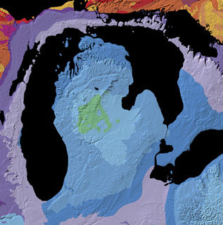
The Michigan Basin is a geologic basin centered on the Lower Peninsula of the U.S. state of Michigan. The feature is represented by a nearly circular pattern of geologic sedimentary strata in the area with a nearly uniform structural dip toward the center of the peninsula.

The geology of England is mainly sedimentary. The youngest rocks are in the south east around London, progressing in age in a north westerly direction. The Tees-Exe line marks the division between younger, softer and low-lying rocks in the south east and the generally older and harder rocks of the north and west which give rise to higher relief in those regions. The geology of England is recognisable in the landscape of its counties, the building materials of its towns and its regional extractive industries.
The Lachlan Fold Belt (LFB) or Lachlan Orogen is a geological subdivision of the east part of Australia. It is a zone of folded and faulted rocks of similar age. It dominates New South Wales and Victoria, also extending into Tasmania, the Australian Capital Territory and Queensland. It was formed in the Middle Paleozoic from 450 to 340 Mya. It was earlier known as Lachlan Geosyncline. It covers an area of 200,000 km2.
This is a list of articles related to plate tectonics and tectonic plates.

The Iapetus Suture is one of several major geological faults caused by the collision of several ancient land masses forming a suture. It represents in part the remains of what was once the Iapetus Ocean. Iapetus was the father of Atlas in Greek mythology, making his an appropriate name for what used to be called the 'Proto-Atlantic Ocean'. When the Atlantic Ocean opened, in the Cretaceous period, it took a slightly different line from that of the Iapetus suture, with some originally Laurentian rocks being left behind in north-west Europe and other, Avalonian, rocks remaining as part of Newfoundland.

The geology of Massachusetts includes numerous units of volcanic, intrusive igneous, metamorphic and sedimentary rocks formed within the last 1.2 billion years. The oldest formations are gneiss rocks in the Berkshires, which were metamorphosed from older rocks during the Proterozoic Grenville orogeny as the proto-North American continent Laurentia collided against proto-South America. Throughout the Paleozoic, overlapping the rapid diversification of multi-cellular life, a series of six island arcs collided with the Laurentian continental margin. Also termed continental terranes, these sections of continental rock typically formed offshore or onshore of the proto-African continent Gondwana and in many cases had experienced volcanic events and faulting before joining the Laurentian continent. These sequential collisions metamorphosed new rocks from sediments, created uplands and faults and resulted in widespread volcanic activity. Simultaneously, the collisions raised the Appalachian Mountains to the height of the current day Himalayas.
Uriconian rocks are volcanic rocks found in parts of Shropshire, United Kingdom. The name relates to Uriconio, the Latin name for an Iron Age hillfort on the summit of the Wrekin, a hill formed of Uriconian rock.

The Dent Group is a group of Upper Ordovician sedimentary and volcanic rocks in north-west England. It is the lowermost part of the Windermere Supergroup, which was deposited in the foreland basin formed during the collision between Laurentia and Avalonia. It lies unconformably on the Borrowdale Volcanic Group. This unit was previously known as the Coniston Limestone Group or Coniston Limestone Formation and should not be confused with the significantly younger Coniston Group.

The main points that are discussed in the geology of Iran include the study of the geological and structural units or zones; stratigraphy; magmatism and igneous rocks; ophiolite series and ultramafic rocks; and orogenic events in Iran.
The geology of Maine is part of the broader geology of New England and eastern North America.
The geology of Kyrgyzstan began to form during the Proterozoic. The country has experienced long-running uplift events, forming the Tian Shan mountains and large, sediment filled basins.

The geology of Bulgaria consists of two major structural features. The Rhodope Massif in southern Bulgaria is made up of Archean, Proterozoic and Cambrian rocks and is a sub-province of the Thracian-Anatolian polymetallic province. It has dropped down, faulted basins filled with Cenozoic sediments and volcanic rocks. The Moesian Platform to the north extends into Romania and has Paleozoic rocks covered by rocks from the Mesozoic, typically buried by thick Danube River valley Quaternary sediments. In places, the Moesian Platform has small oil and gas fields. Bulgaria is a country in southeastern Europe. It is bordered by Romania to the north, Serbia and North Macedonia to the west, Greece and Turkey to the south, and the Black Sea to the east.
The geology of Romania is structurally complex, with evidence of past crustal movements and the incorporation of different blocks or platforms to the edge of Europe, driving recent mountain building of the Carpathian Mountains. Romania is a country located at the crossroads of Central, Eastern, and Southeastern Europe. It borders the Black Sea to the southeast, Bulgaria to the south, Ukraine to the north, Hungary to the west, Serbia to the southwest, and Moldova to the east.
The geology of Yukon includes sections of ancient Precambrian Proterozoic rock from the western edge of the proto-North American continent Laurentia, with several different island arc terranes added through the Paleozoic, Mesozoic and Cenozoic, driving volcanism, pluton formation and sedimentation.
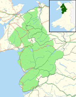
The geology of Snowdonia National Park in North Wales is dominated by sedimentary and volcanic rocks from the Cambrian and Ordovician periods with intrusions of Ordovician and Silurian age. There are Silurian and Cenozoic sedimentary rocks on the park's margins. The succession was intensely faulted and folded during the Caledonian Orogeny. The region was uplifted as the North Atlantic Ocean opened during the Cenozoic. The current mountainous landscape arises from repeated glaciations during the Quaternary period.
References
- ↑ Howells, M.F. 2007 British Regional Geology: Wales (Keyworth, Nottingham, British Geological Survey)
- ↑ Hunter, A. & Easterbrook, G. 2004 The Geological History of the British Isles, The Open University, Milton Keynes ISBN 0-7492-0138-X
- ↑ Toghill, P. 2000 The Geology of Britain: an introduction Airlife Publishing. ISBN 1-84037-404-7