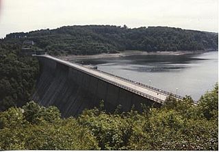
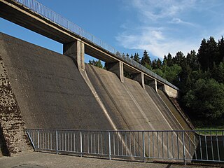
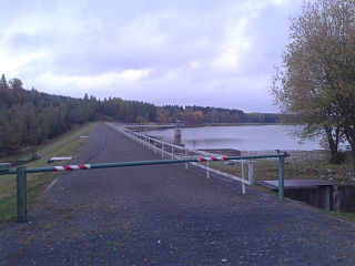
Dam wall
The actual dam is a 43.5 m (143 ft) high gravity dam made of 16 segments that is 30 m (98 ft) above the valley floor and 3 metres (9.8 ft) wide at the crest. The individual segments of the dam are sealed on the upstream side with copper sheets set into the concrete. In addition the joints are sealed with tar and hemp. The flexure of the individual segments under water pressure is constantly monitored. By means of pendulums suspended on the dam wall the degree of flex can be measures. The movement of segments relative to one another is also under constant observation. The wall has several galleries for inspection purposes. Two bottom outlets have been installed at the base. The huge annular piston valves can deliver up to 75 m3/s (2,600 cu ft/s) of water. It is currently being investigated whether the water outflow can be used for energy purposes.
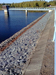
The bedrock consists of manganese slate that is not particularly watertight. So that the dam wall is not lifted up from underneath by water pressure at the base, the pressure at the foot is relieved by over 40 bubble caps (Glocken) with drainage pipes (Steigleitungen). The building water pressure is measured at intervals. By means of the observation well, the long term condition of the mountain is investigated.
The operator, the Saxony-Anhalt Dam Company (Talsperrenbetrieb Sachsen-Anhalt), has made the Wendefurth Dam accessible to visitors. In an adjacent engineering park, old dam components are given a final use.
There is a good viewing point over the dam and reservoir at Talsperrenblick on the hillside beyond the eastern end of the reservoir, accessible on footpaths from Wendefurth. It is checkpoint 62 in the Harzer Wandernadel hiking system.

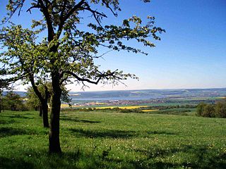
The Bode is a river in the German state of Saxony-Anhalt, a left tributary of the Saale. It rises in the Harz mountains and drains them in a northerly direction. After 169 kilometres (105 mi) it discharges into the Saale at Nienburg. The river is named after a legendary giant, the wild, rampaging, Bohemian, Prince Bodo, who, according to the Rosstrappe legend changed into a marauding dog that guarded the crown of Princess Brunhilde in the Kronensumpf in the present-day Bode Gorge. The gorge is the narrow section of the Bode valley between Treseburg and Thale.
The Rappbode Dam is the largest dam in the Harz region as well as the highest dam in Germany. Together with several other dams and retention basins, it forms the flood protection system for the eastern Harz.
The Birnbaumteich is a reservoir in the German state of Saxony-Anhalt, located near Neudorf in the Harz mountains.
The Oker Dam is a dam in the Harz mountains in Lower Saxony, Germany. It is fed by the River Oker.
The Zillierbach Dam lies in the East Harz in the German state of Saxony-Anhalt near the town of Elbingerode (Harz) and impounds the Zillierbach stream. It supplies drinking water to several villages in the High Harz as well as the town of Wernigerode; it also provides flood protection.

The Königshütte Dam is a dam in the German state of Saxony-Anhalt in the Harz mountains. It impounds the River Bode and lies between Königshütte and Susenburg. It is a so-called storage reservoir (Überleitungssperre) forming part of the Rappbode Dam system.

Wendefurth Power Station is a pumped-storage hydroelectric power station on the reservoir of the Wendefurth Dam near Wendefurth in the Harz mountains of central Germany.

The Rappbode Auxiliary Dam is one of the two auxiliary dams in the Rappbode Dam system. This is the heart of the Rappbode Dam system in the East Harz, which is operated by the Saxony-Anhalt Dam Company and which also includes the Hassel Auxiliary Dam and the Königshütte, Mandelholz and Wendefurth dams.
The Kelbra Dam is a dam on the River Helme in the German state of Saxony-Anhalt. Behind the dam is the lake known as the Kelbra Reservoir or Kelbra Flood Retention Basin.

The Rappbode is a right-hand, southwestern tributary of the River Bode in the Harz mountains in the German state of Saxony-Anhalt. In its lower reaches it is impounded by the Rappbode Dam, the largest dam in the Harz.
The Hassel Auxiliary Dam or Hassel Dam is an auxiliary dam or pre-dam on the Rappbode Reservoir in the Harz mountains of central Germany. It is located near Hasselfelde in the state of Saxony-Anhalt and impounds the waters of the Hassel, the eastern of the two headwaters of the Rappbode Reservoir. Together with its auxiliary dams, the reservoir supplies drinking water and is owned by the Saxony-Anhalt Dam Company. The purpose of the auxiliary dam is to pre-clean water mechanically and biologically before it flows into the main reservoir. Water can be collected from various heights and diverted to the reservoir.
The Kiliansteich is one of the oldest reservoirs in Germany. The reservoir is located near Straßberg (Harz) in the German state of Saxony-Anhalt and supplies drinking water. It impounds the Büschengraben stream. The lake is part of the heritage area (Flächendenkmal) of the Lower Harz Pond and Ditch System.

Within the Lower Harz region are still many traces of the historical water management facilities used by the mining industry. In addition to water-carrying ditches and ponds, there are also long-abandoned ditches and dry pond beds. The Lower Harz Pond and Ditch System, which forms the major part of these old water management facilities, lies in the central Lower Harz, almost entirely within the borough of the present-day town of Harzgerode.
The Frankenteich is an old reservoir in the Harz Mountains of central Germany. It was constructed in 1716 under the direction of mining director (Bergwerksdirektor), Christian Zacharias Koch, for the mining industry and is the largest pond in the Lower Harz. Since 1901 it has supplied drinking water to the village of Straßberg. It impounds the Rödelbachgraben, which discharges into the Selke in Straßberg. A mining ditch runs past the foot of the dam from the Kiliansteich which, like the Frankenteich, belongs to the heritage area designated as the Lower Harz Pond and Ditch System.
The Rödelbachgraben, usually called the Rödelbach and also incorrectly referred to as the Rieschengraben, is a river of Saxony-Anhalt, Germany.
The Teufelsteich was one of the oldest reservoirs in the Harz Mountains of central Germany.

The Fürstenteich is a reservoir near Silberhütte in the German state of Saxony-Anhalt. It has an earth-filled dam with an impervious core. It impounds the Teufelsgrundbach stream.

The Harz/Saxony-Anhalt Nature Park is situated n the districts of Harz and Mansfeld-Südharz in the German state of Saxony-Anhalt. The nature park which lies in the Harz Mountains was founded in 2003 and has an area of around 1,660 km². It is looked after by the Harz Regional Association.
This page is based on this
Wikipedia article Text is available under the
CC BY-SA 4.0 license; additional terms may apply.
Images, videos and audio are available under their respective licenses.
