
The Pacific Highway is a 790-kilometre-long (490 mi) national highway and major transport route along the central east coast of Australia, with the majority of it being part of Australia's national route 1.

Ballina is a town in the Northern Rivers region of New South Wales, Australia, and the seat of the Ballina Shire local government area. Ballina's urban population at June 2018 was 26,381. The town lies on the Richmond River and serves as a gateway to Byron Bay.

The Bruxner Highway is a 420-kilometre (260 mi) state highway located in New South Wales, Australia. The highway forms an east–west link from the Northern Rivers coast, across the Northern Tablelands in northern New South Wales, close to the border with Queensland.

The N5 road is a national primary road in Ireland, connecting Longford town with Westport. It is the main access route from Dublin to most of County Mayo, including the county's largest towns, Castlebar, Ballina, and Westport.

Goonellabah is the eastern suburb of Lismore, New South Wales, Australia, and is on the Bruxner Highway. At the 2006 census, Goonellabah had a population of 12,527 people.

The N59 road is a national secondary road in Ireland. It commences in County Sligo, south of Sligo Town at the Belladrehid interchange with the N4 north of Ballysadare. The route circles around the west of Ireland, passing west from Sligo into County Mayo and through Ballina. The N59 continues around Mayo, proceeding indirectly to Westport. Continuing south through Mayo into County Galway, the road passes through the village of Leenaun. The 182-year-old bridge in the centre of the village, carrying the road across the River Lahill, collapsed in floods on 18 July 2007. Due to the local terrain and road network, the diversionary route for getting from the south of the village to Westport was 110 km long. A temporary bridge was opened eight days after the floods, on 27 July. It has since been replaced by a new bridge.

The N26 road is a national primary road in northeast County Mayo in Ireland connecting the N5 road at Swinford with the N58 at Foxford and then on to the N59 road at Ballina. The road also meets six regional roads along its route, and it is 29.79 kilometres (18.51 mi) long.

Ballina, meaning "Mouth of the Ford", is a village that lies on the River Shannon in County Tipperary, Ireland. It is situated on the eastern shore of Lough Derg across from its 'twin-town' of Killaloe on the west bank of the lake. The towns are joined by Killaloe Bridge.

Tintenbar is a village located on the Far North Coast of New South Wales.

Ballina Shire is a local government area in the Northern Rivers region of New South Wales, Australia. The Shire was formed on 1 January 1977 by the amalgamation of the Municipality of Ballina and Tintenbar Shire. The Shire is located adjacent to the Tasman Sea and the Pacific Highway. The Council seat is located in the town of Ballina. The population of the Ballina Shire area was 44,208 in June 2018.
Teven is a village located on the Far North Coast of New South Wales.
East Ballina, New South Wales is a locality of the town of Ballina, New South Wales and has three main beaches including Angels Beach, Shelly Beach and Lighthouse Beach. East Ballina also has the historic Lighthouse on Lighthouse Hill, which was built in 1879.
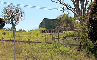
Nashua is a former railway station and locality in the north-east of New South Wales, between Lismore and Byron Bay.
Ballina Coast High School is a government-funded co-educational comprehensive secondary day school, located on Cherry Street, in Ballina, in the Northern Rivers region of New South Wales, Australia.

A Mayo County Council election was held in Ireland on 23 May 2014 as part of that year's local elections. Thirty councillors were elected for a five-year term of office from four local electoral areas by proportional representation with a single transferable vote. This represented a reduction of 1 councillor since 2009 and 1 a reduction in 2 electoral areas.

Ballina is a town in north County Mayo, Ireland. It lies at the mouth of the River Moy near Killala Bay, in the Moy valley and Parish of Kilmoremoy, with the Ox Mountains to the east and the Nephin Beg mountains to the west. The town occupies two baronies; Tirawley on the west bank of the Moy River, and Tireragh, a barony within the County of Sligo, on its east banks. As of 2016, the population of Ballina was 10,171.
South Ballina is a locality located in the Northern Rivers Region of New South Wales - bounded by the Richmond River to the north, the Tasman Sea to the east, and Keith Hall to the south and west. Across the river to the north, is the town of Ballina.
Uralba is a rural locality located on the Far North Coast of New South Wales. Its name means "place of plenteous quartz stones".

Ballinea is a village in County Westmeath, Ireland. It is located on the R390 road, to the west of Mullingar.
The 1998–99 All-Ireland Senior Club Football Championship was the 29th staging of the All-Ireland Senior Club Football Championship since its establishment by the Gaelic Athletic Association in 1970-71. The championship began on 4 October 1998 and ended on 17 March 1999.
