Related Research Articles

The Rio Grande in the United States or the Río Bravo in Mexico, also known as P’osoge in Tewa and Tó Ba’áadi in Navajo, is one of the principal rivers in the southwestern United States and in northern Mexico. The length of the Rio Grande is 1,896 miles (3,051 km), making it the 4th longest river in the United States and in North America by main stem. It originates in south-central Colorado, in the United States, and flows to the Gulf of Mexico. The Rio Grande drainage basin (watershed) has an area of 182,200 square miles (472,000 km2); however, the endorheic basins that are adjacent to and within the greater drainage basin of the Rio Grande increase the total drainage-basin area to 336,000 square miles (870,000 km2).

Rio Grande County is a county located in the U.S. state of Colorado. As of the 2020 census, the population was 11,539. The county seat is Del Norte. The county is named for the Rio Grande, which flows through the county.
Chama may refer to:

South Fork is a statutory town in Rio Grande County, Colorado, United States. It lies at the confluence of the South Fork and Rio Grande rivers. The population was 510 at the 2020 census.

Chama is a village in Rio Arriba County, New Mexico, United States. The population was 917 at the 2020 census. The village is located in the Rocky Mountains about 7 miles (11 km) south of the Colorado-New Mexico border.

The Cumbres and Toltec Scenic Railroad, often abbreviated as the C&TSRR, is a 3 ft narrow-gauge heritage railroad that operates on 64 miles (103 km) of track between Antonito, Colorado, and Chama, New Mexico, in the United States. The railroad is named for two geographical features along the route: the 10,015-foot (3,053 m)-high Cumbres Pass and the Toltec Gorge. Originally part of the Denver and Rio Grande Western Railroad's narrow-gauge network, the line has been jointly owned by the states of Colorado and New Mexico since 1970.
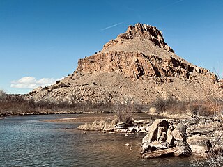
The Rio Chama, a major tributary river of the Rio Grande, is located in the U.S. states of Colorado and New Mexico. The river is about 130 miles (210 km) long altogether. From its source to El Vado Dam its length is about 50 miles (80 km), from El Vado Dam to Abiquiu Dam is about 51 miles (82 km), and from Abiquiu Dam to its confluence with the Rio Grande is about 34 miles (55 km).

Cumbres Pass, elevation 10,022 ft (3,055 m), is a mountain pass in the San Juan Mountains in Colorado, United States. The pass is traversed by State Highway 17 and the Cumbres and Toltec Scenic Railroad. The highway has a moderate 5.8% approach on the north side and a gentler, 4% approach on the south side. It is rarely closed in winter and does not normally cause problems for vehicles, since the road is not a major through highway.

Chama is an unincorporated community and U.S. Post Office in Costilla County, Colorado, United States.

Heron Lake is a reservoir in Rio Arriba County, New Mexico in the southwestern United States. The reservoir is part of the San Juan–Chama Project, which connects the San Juan River in Colorado to the Rio Chama, which is part of the Rio Grande watershed. Lake Heron is 80 miles northwest of Santa Fe.

The Brazos Mountains is a range in far northern Rio Arriba County, in northern New Mexico in the southwestern United States. The range is part of the Tusas Mountains, which extended slightly into Colorado. A high crest runs from the border with Colorado for over 20 miles (32 km) in a south-southeasterly direction. The high point of the range at 11,405 feet (3,476 m) is on Grouse Mesa, at the Brazos Benchmark. Two miles (3 km) to the southeast is the more distinctive Brazos Peak, at 11,288 feet.

The San Juan–Chama Project is a U.S. Bureau of Reclamation interbasin water transfer project located in the states of New Mexico and Colorado in the United States. The project consists of a series of tunnels and diversions that take water from the drainage basin of the San Juan River – a tributary of the Colorado River – to supplement water resources in the Rio Grande watershed. The project furnishes water for irrigation and municipal water supply to cities along the Rio Grande including Albuquerque and Santa Fe.
Heron Dam is a storage dam Rio Arriba County, in northern New Mexico in the southwestern United States, just north of the El Vado Dam. It is owned and operated by the United States Bureau of Reclamation. The dam is about 9 miles west of the town of Tierra Amarilla.
The Rio Brazos is a 42-mile (68 km) long river flowing through northern New Mexico in the United States. It rises in the Tusas Mountains, a subrange of the San Juan Mountains, and runs generally southwest to a confluence with the Rio Chama, part of the larger Rio Grande system.
Rio Chamita is a tributary of the Rio Chama in the United States. The stream flows south from a source in Archuleta County, Colorado to a confluence with the Rio Chama in Rio Arriba County, New Mexico.
East Fork Rio Chama is a tributary of the Rio Chama in southern Colorado. The stream flows south from Dipping Lakes near the continental divide in Conejos County, Colorado to a confluence with the West Fork Rio Chama in Archuleta County, Colorado that forms the Rio Chama.

The Tusas Mountains are a mountain range in northern New Mexico, extending slightly into southern Colorado. They are considered the southeasternmost part of the San Juan Mountains. Grouse Mesa, 11,407 feet (3,477 m), is the highest peak in the range. The mountains are located to the west of Taos and northwest of Santa Fe. The Tusas Mountains are a wide region of upland mesas and gently sloping mountains, dissected in places by deep canyons.
References
- ↑ "West Fork Rio Chama". Geographic Names Information System . United States Geological Survey, United States Department of the Interior . Retrieved 2013-05-22.
| | This article related to a river in Colorado is a stub. You can help Wikipedia by expanding it. |