West Garden Grove, Garden Grove, California

Last updated

West Grove Business District
West Grove
Neighborhood of Garden Grove
West Grove Business District
ZCTA 92845 West Garden Grove, California.gif
Location of West Grove neighborhood, map of ZIP Code Tabulation Area 92845, corresponding to West Garden Grove.
Garden Grove, California Map.gif
Map of Garden Grove, California, with West Grove connected to the rest of the city by a narrow corridor.
Coordinates: 33°47′18″N118°01′16″W / 33.78833°N 118.02111°W / 33.78833; -118.02111
CountryFlag of the United States.svg  USA
Population
 (2010)
  Total16,333

West Grove, officially recognized as the West Grove Business District by the City of Garden Grove, and sometimes called West Garden Grove, is a neighborhood in the city of Garden Grove, located in Orange County, California, United States. West Grove encompasses the pene-exclave western portion of the city of Garden Grove. It is bordered to the north by Cypress, to the west by Los Alamitos and Seal Beach, to the south by Westminster, and to the east by Stanton, and connected to the rest of Garden Grove by a narrow strip along Garden Grove Boulevard. [1] It includes the entire 92845 ZIP Code, which is designated as the areas west of Knott Avenue to the Seal Beach and Los Alamitos city borders, and the industrial area east of Knott Avenue to the Stanton border. The community is more "affluent" than the rest of Garden Grove, with a median income $25,000 greater than the main body of the city. [2] There is also less crime, a lower poverty rate, and lower population density compared to the rest of Garden Grove. As of the 2010 Census, 16,333 people reside in West Grove. [3]

Contents

Historically, the term West Garden Grove, or West Grove, was used only on unofficial basis and was not recognized by the city of Garden Grove; [4] however, on May 8, 2018, the Garden Grove City Council approved a resolution by Garden Grove City Councilman Kris Beard of District One, the city election district that covers West Grove, officially recognizing West Grove Business District as a district. [5]

Demographics

As of the census of 2010 for the 92845 ZIP Code, there were 16,333 people, 5,626 households, and 4,395 families residing in the community. The population density was 8,166.5/mi2. There were 5,751 housing units at an average density of 2,875.5/mi2. The racial makeup of the community was 82.3% White, 1.6% Black or African American, 1.2% Native American or Alaskan Native, 13.8% Asian, 1.0% Pacific Islander, 5.2% from other races, and 4.8% from two or more races. 16.2% of the population were Hispanic or Latino of any race.[ citation needed ]

There were 5,626 households, out of which 33.2% had children under the age of 18 living with them. 61.5% of family households were married couples living together, 11.4% had a female householder with no husband present, 5.2% had a male householder with no wife present, and 21.9% were non-families. 17.5% of all households were made up of individuals, and 33.1% of households had someone living alone who was 65 years of age or older. The average household size was 2.89 and the average family size was 3.26.[ citation needed ]

In the community, the population was spread out, with 23.1% under the age of 18, 5.7% from 20 to 24, 23.0% from 25 to 44, 29.1% from 45 to 64, and 16.0% who were 65 years of age or older. The median age was 42.1 years. For every 100 females there were 95.2 males. For every 100 females age 18 and over, there were 92.0 males.[ citation needed ]

The median income for a household in the community was $102,530, and the median income for a family was $108,289. Males had a median income of $69,735 versus $55,949 for females. The per capita income for the city was $33,634.[ citation needed ]

Official Recognition of West Grove

Historically, the term West Garden Grove, or West Grove, was used only on unofficial basis and was not officially recognized by the city of Garden Grove [6] On April 24, 2018, West Grove's representative to the Garden Grove City Council, Kris Beard, proposed a resolution that would officially designate West Grove as a business district within the city. [7]

Councilman Beard's resolution was met with mixed feelings. [7] Supporters felt that designating West Grove as an official neighborhood would make it easier to attract upscale chains to the area, since they would be looking at only West Grove's demographic information, and not the entire city. West Grove has about a $25,000 a year greater median household income than the rest of the city. [2] Additionally, West Grove has a much lower crime rate, a lower poverty rate, and lower population density compared to the rest of Garden Grove. [3]

Opponents of Beard's proposal felt the resolution was divisive and secretly racist. [7] Opponents were quick to point out that a higher density of people of color, namely Vietnamese, live on the East Side of the city. Opponents specifically objected to Beard's use of "all American" in the resolution as being racist. [7]

On May 8, 2018, after Beard received comments on the resolution, and amended it to make the wording less divisive, the Garden Grove City Council officially approved the resolution, officially recognizing West Grove as a neighborhood of the city, and creating the West Grove District. [5]

Government

West Garden Grove is part of the larger City of Garden Grove and receives most of its municipal services from the city. Certain other municipal services, such as vector control, are provided by the Orange County government.

Parks and recreation

In West Grove, there are three community parks, Eastgate Park, Westgrove Park, and Edgar Park. The westernmost border is located 4.5 miles from the Pacific Ocean. In the eastern part of the community, an abundant supply of jobs are located in the industrial park east of Knott Avenue. There are three strip malls in the community located along Valley View Street. The Garden Grove Tibor Rubin Library (formerly the Garden Grove West Library) is located west of Valley View Street on the corner of Chapman and Bailey Street. [8]

Education

West Grove is served under the Garden Grove Unified School District, and has 7 schools located within its boundaries; 5 elementary schools, 1 intermediate school, and 1 high school. There are no colleges, or universities within the community limits, nor are there any special education schools.

Elementary schools

Intermediate schools

High schools

Major surface streets

East to west

North to south

Notables

Related Research Articles

<span class="mw-page-title-main">Fountain Valley, California</span> City in California, United States

Fountain Valley is a suburban city in Orange County, California. The population was 57,047 at the 2020 census.

<span class="mw-page-title-main">Anaheim, California</span> City in the United States

Anaheim is a city in northern Orange County, California, United States, part of the Greater Los Angeles area. As of the 2020 census, the city had a population of 346,824, making it the most populous city in Orange County, the tenth-most populous city in California, and the 55th-most populous city in the United States. The second largest city in Orange County in terms of land area, Anaheim is known for being the home of the Disneyland Resort, the Anaheim Convention Center, and two major league sports teams: the Los Angeles Angels of Major League Baseball (MLB) and the Anaheim Ducks of the National Hockey League (NHL).

<span class="mw-page-title-main">Covina, California</span> City in California, United States

Covina is a city in the San Gabriel Valley region of Los Angeles County, California, United States, about 22 miles (35 km) east of Downtown Los Angeles The population was 51,268 according to the 2020 census, up from 47,796 at the 2010 census. The city's slogan, "One Mile Square and All There", was coined when the incorporated area of the city was only one square mile (2.6 km2).

<span class="mw-page-title-main">Buena Park, California</span> City in California, United States

Buena Park is a city in northern Orange County, California, United States. As of the 2020 census its population was 84,034. It is the location of several tourist attractions, including Knott's Berry Farm. It is about 12 miles (20 km) northwest of downtown Santa Ana, the county seat, and is within the Los Angeles metropolitan area.

<span class="mw-page-title-main">Cypress, California</span> City in California, United States

Cypress is a city in northwestern Orange County within Southern California. Its population was 50,151 at the 2020 census.

<span class="mw-page-title-main">Garden Grove, California</span> City in California, United States

Garden Grove is a city in northern Orange County, California, United States. The population was 171,949 at the 2020 census. State Route 22, also known as the Garden Grove Freeway, passes through the city in an east–west direction. The western portion of the city is known as West Garden Grove.

<span class="mw-page-title-main">Placentia, California</span> City in California, United States

Placentia is a city in northern Orange County, California, United States. Its population was 51,233 during the 2020 census, up from 46,488 in the 2000 census. This includes the community of Atwood, which is included in the city of Placentia, and is located in its southeastern quadrant. Primarily referred to as a bedroom community, Placentia is known for its quiet neighborhoods.

<span class="mw-page-title-main">Stanton, California</span> City in California, United States

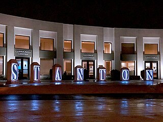
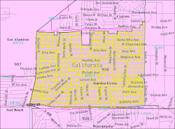
Stanton is a city in northern Orange County, California, United States, within the Los Angeles metropolitan area. The population was 37,962 at the 2020 United States Census. The city was incorporated in 1956 and operates under the council–manager form of government, providing a full range of municipal services. Stanton is bounded by Cypress on the west, Anaheim on the north, and east, and Garden Grove on the east and south.

<span class="mw-page-title-main">Westminster, California</span> City in California, United States

Westminster is a city in western Orange County, California, United States. Westminster was founded in 1870 by Rev. Lemuel Webber as a Presbyterian temperance colony and was incorporated in 1957.

<span class="mw-page-title-main">Home Gardens, California</span> Census-designated place in California, United States

Home Gardens is a census-designated place (CDP) in Riverside County, California, United States. It is within the City of Corona's sphere of influence. The population was 11,203 at the 2020 census, down from 11,507 at the 2010 census.

<span class="mw-page-title-main">Orange Park, Florida</span> Town in the state of Florida, United States

Orange Park is a town in Clay County, Florida, United States. It is a suburb of Jacksonville, in neighboring Duval County. The population was 9,089 at the 2020 census. The name "Orange Park" is additionally applied to a wider area of northern Clay County outside the town limits, covering such communities as Lakeside, Bellair-Meadowbrook Terrace and Oakleaf Plantation.

<span class="mw-page-title-main">Winter Park, Florida</span> City in Florida, United States

Winter Park is a city in Orange County, Florida, United States. The population was 29,795 according to the 2020 census. It is part of the Orlando–Kissimmee–Sanford, Florida Metropolitan Statistical Area.

<span class="mw-page-title-main">Franklin Park, Illinois</span> Village in Illinois, United States

Franklin Park is a village in Cook County, Illinois, United States. The population was 18,467 at the 2020 census, up from 18,333 at the 2010 census. It was named for real estate broker Lesser Franklin who bought acres of the area when it was a majority of farming fields.

<span class="mw-page-title-main">Parkville, Maryland</span> Census-designated place in Maryland, United States

Parkville is an unincorporated community and census-designated place in Baltimore County, Maryland, United States. As of the 2010 census, the population was 30,734.

<span class="mw-page-title-main">Kentwood, Michigan</span> City in Michigan, United States

Kentwood is a city in Kent County in the U.S. state of Michigan. The population was 54,304 as of the 2020 census. The city is bordered on the northwest by Grand Rapids and is the third most-populated municipality in the Grand Rapids metropolitan area.

<span class="mw-page-title-main">Wayne, Michigan</span> City in Michigan, United States

Wayne is a city in Wayne County in the U.S. state of Michigan. A western suburb of Detroit, Wayne is located about 18 miles (29 km) southwest of downtown Detroit. As of the 2020 census, the city had a population of 17,713.

<span class="mw-page-title-main">Orange, Virginia</span> Town in Virginia, United States

Orange is a town and the county seat of Orange County, Virginia, United States. The population was 5,062 at the 2020 census, representing a 7.2% increase since the 2010 census. Orange is 28 miles (45 km) northeast of Charlottesville, 88 miles (142 km) southwest of Washington, D.C., and 4 miles (6 km) east of Founding Father and fourth U.S. president James Madison's plantation of Montpelier.

<span class="mw-page-title-main">West Haven, Connecticut</span> City in Connecticut, United States

West Haven is a city in New Haven County, Connecticut, United States, located on the coast of Long Island Sound. The city is part of the South Central Connecticut Planning Region. At the 2020 census, the population of the city was 55,584.

<span class="mw-page-title-main">West Oak Lane, Philadelphia</span> Neighborhood of Philadelphia in Pennsylvania, United States

West Oak Lane is a neighborhood in Northwest Philadelphia, Pennsylvania, United States. The neighborhood was developed primarily between the early 1920s and late 1930s, with the areas near to Cedarbrook constructed after World War II. At the northeast corner of Limekiln Pike and Washington Lane was the site of the Cedar Park Inn, a historic tavern built in the early 19th century, which was torn down sometime after 1931 as the neighborhood was being fully developed.

<span class="mw-page-title-main">Pacifica High School (Garden Grove, California)</span> Public school in Garden Grove, California, United States

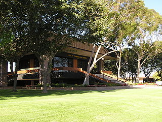
Pacifica High School is a high school in Garden Grove, California, United States, within the Garden Grove Unified School District. It opened in 1965 and has enrolled more than two thousand students yearly. The communities serving Pacifica are western Garden Grove and sections of Stanton and Cypress.

References

  1. Garden Grove Land Use Map, Garden Grove, California. Retrieved November 12, 2007.
  2. 1 2 "2000 Census". factfinder.census.gov. Retrieved February 3, 2024.
  3. 1 2 Bureau, U. S. Census. "American FactFinder". wayback.archive-it.org. Retrieved February 3, 2024.
  4. Hong, Binh Ha (December 11, 2000). "West Side Story". The Orange County Register . "Some residents in west Garden Grove (although city officials don't like to call it that) say their side of town, with its abundance of neatly tended lawns and 1960s tract houses, is neglected by the city..."
  5. 1 2 "Public Agenda". gardengrove.novusagenda.com.
  6. Hong, Binh Ha (December 11, 2000). "West Side Story". The Orange County Register . "Some residents in west Garden Grove. (although city officials don't like to call it that) say their side of town, with its abundance of neatly tended lawns and 1960s tract houses, is neglected by the city..."
  7. 1 2 3 4 "Garden Grove City Council Meetings". ci.garden-grove.ca.us.
  8. "Library Information". ocpl.org.
  9. 1 2 1985 Pacifica High School yearbook.
  10. "Jon Dorenbos Stats, News and Video - LS". NFL.com. Retrieved February 3, 2024.
  11. "She Carries on For Us". chicagotribune.com.
  12. "Here Comes the Groom". people.com.
  13. 1 2 3 4 5 "Famous People from Pacifica". Pacifica School History. Garden Grove Unified School District. Archived from the original on September 19, 2008.
  14. 1978 Pacifica High School yearbook
  15. 1971 Pacifica High School yearbook WGG Library