
San Francisco Bay is a shallow estuary in the U.S. state of California. It is surrounded by a contiguous region known as the San Francisco Bay Area, and is dominated by the large cities of San Francisco, San Jose, and Oakland.

Southcentral Alaska is the portion of the U.S. state of Alaska consisting of the shorelines and uplands of the central Gulf of Alaska. Most of the population of the state lives in this region, concentrated in and around the city of Anchorage.

Barbed wire, also known as barb wire, occasionally corrupted as bobbed wire or bob wire, is a type of steel fencing wire constructed with sharp edges or points arranged at intervals along the strands. It is used to construct inexpensive fences and is used atop walls surrounding secured property. It is also a major feature of the fortifications in trench warfare.

The Golden Gate is a strait on the west coast of North America that connects San Francisco Bay to the Pacific Ocean. It is defined by the headlands of the San Francisco Peninsula and the Marin Peninsula, and, since 1937, has been spanned by the Golden Gate Bridge. The entire shoreline and adjacent waters throughout the strait are managed by the Golden Gate National Recreation Area.
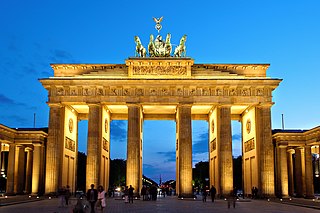
The Brandenburg Gate is an 18th-century neoclassical monument in Berlin, built on the orders of Prussian king Frederick William II after the temporary restoration of order during the Batavian Revolution. One of the best-known landmarks of Germany, it was built on the site of a former city gate that marked the start of the road from Berlin to the town of Brandenburg an der Havel, which used to be capital of the Margraviate of Brandenburg.
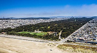
Golden Gate Park, located in San Francisco, California, United States, is a large urban park consisting of 1,017 acres (412 ha) of public grounds. It is administered by the San Francisco Recreation & Parks Department, which began in 1871 to oversee the development of Golden Gate Park. Configured as a rectangle, it is similar in shape to but 20 percent larger than Central Park in New York City, to which it is often compared. It is over three miles (4.8 km) long east to west, and about half a mile (0.8 km) north to south. With 24 million visitors annually, Golden Gate is the third most-visited city park in the United States after Central Park and the Lincoln Memorial.
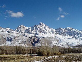
The Taurus Mountains, are a mountain complex in southern Turkey, separating the Mediterranean coastal region from the central Anatolian Plateau. The system extends along a curve from Lake Eğirdir in the west to the upper reaches of the Euphrates and Tigris rivers in the east. It is a part of the Alpide belt in Eurasia.

Gates of the Arctic National Park and Preserve is an American national park that protects portions of the Brooks Range in northern Alaska. The park is the northernmost national park in the United States, situated entirely north of the Arctic Circle. The park is the second largest in the US at 8,472,506 acres, slightly larger in area than Belgium.
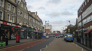
Forest Gate is a suburban town in east London, England, in the London Borough of Newham.

Turon River, a perennial stream that is part of the Macquarie catchment within the Murray–Darling basin, is located in the central western district of New South Wales, Australia. Partly situated in the Turon National Park, the river is host to numerous recreational and tourist activities such as horse riding, gold panning, canoeing, camping, and seasonal fishing.

The Chumash Wilderness is a 38,150 acres (15,440 ha) wilderness area within the southern Los Padres National Forest. It is located in the Transverse Ranges, in northern Ventura County and southwestern Kern County in California.
Romania's landscape is almost evenly divided among mountains, hills, and plains. These varied relief forms spread rather symmetrically from the Carpathian Mountains, which reach elevations of more than 2,400 metres, to the Danube Delta, which is just a few metres above sea level.

The Davey River is a perennial river located in the south-west region of Tasmania, Australia.
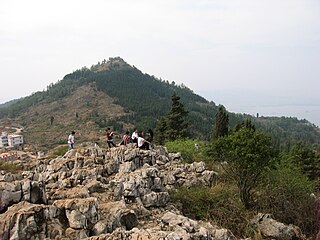
The Western Mountains or Western Hills are a scenic mountain area located 12 km to the west of Kunming, Yunnan, China. They are formed by the Huating, Taihua and Luohan mountain ranges rising above the eastern and northern banks of Dianchi Lake.

Bhamer, is a village with a historical fort in Sakri tehsil of Maharashtra state in India. It is situated at the foot of a great fortified hill lying 48.28 km (30.00 mi) north-west from Dhule city and 4.82 km (3.00 mi) south of Nijampur.
The First Battle of Ürümqi was a conflict in the spring of 1933 between the armies of the Xinjiang provincial government and the Chinese Muslim 36th Division of the national government of China. The Chinese government secretly urged Gen. Ma Zhongying to attack Jin Shuren while at the same time assuring Jin that he was recognized as the legitimate Governor. Fierce fighting broke out at the gates of the city, and one of the Chinese commanders torched a street where the Muslims troops had managed to break through at the West Gate, killing everyone in the vicinity, including refugees. The Muslims were then forced to retreat into the range of machine gun fire, which killed many of them.

The Lulworth Ranges are military firing ranges located between Wareham and Lulworth in Dorset, England. They cover an area of more than 2,830 hectares, are leased in a rolling contract from the Weld Estate by the Ministry of Defence and are part of the Armoured Fighting Vehicles Gunnery School based at Lulworth Camp. The ranges were established in 1917.
The Vale of Glamorgan has 740 listed buildings of which 4% are Grade I listed, 10% Grade II* listed and remainder Grade II listed.

Crowne Plaza Chennai Adyar Park, formerly the Sheraton Park Hotel & Towers, is a five-star hotel located on TTK Road in Chennai, India.

Varugad Fort , in Man lies, as the crow flies, about twelve miles north-west of Dahivadi, within the limits of Panvan village. The best way to it is to camp at Pingli Budrukh four miles south-west of Dahivadi and to travel thence by the Tasganv-Mograla road for about ten miles to Jadhavvadi, a hamlet of Bijvadi village lying almost a quarter of a mile east and within sight of the road; from here a well marked track due west goes to the village of Tondle, and from Tondle a path leads direct to the fort over rough ground broken but perfectly passable by a pony, and skirting the northern base of the long plateau of Panvan. The direction of the path is generally a little north of west and it crosses innumerable small ravines and water-courses which lead through rough hill tracts to the edge of the plateau of which the Man taluka chiefly consists. These streams pour down the bare sides of the main hill range, here some 1,000 to 1,500 feet high, on to the plain of Girvi adjoining the Phaltan taluka. The country all the way from Pingli is terribly bare and rocky. Here the stony hills and ravines are interrupted by fairly level plateaus with tolerable soil and good sites for cultivation and grazing. A few small deer and chinkharawill probably be seen, while cattle are everywhere browsing in considerable numbers. Three hamlets, one of them known as Ghodavadi, are reached, and some well-to-do cultivators will probably meet the visitor and turn out to be Gadkaris or descendants of the ancient hereditary fort garrison. The hamlet is situated on a projection between the two ravines, and has been built on a hill of a truncated conical shape. The hill rises about 250 feet above the level of the plateau, which itself constitutes the summit of the Mahadev range at this point. The cone with the walls on it is seen from a great distance and appears very small indeed. But on near approach it is seen to be but the inner citadel of a place of considerable size and strength for the times in which it was built. On the south-west the outer wall or enceinte is entered by a rude gateway of a single pointed arch about eight feet high and five feet broad. As usual there is a curtain of solid masonry inside. The gate lies about 150 yards east of the edge of the plateau, which there terminates in an almost unbroken vertical precipice of several hundred feet in height and receding in a north-easterly direction. No wall was built along about three hundred yards of this part which is absolutely unscalable, but for the rest of the way the walling is continued along the edge of the cliff in a north-east direction for about another three hundred yards. Here it turns still following the cliff to the south-east for another seven hundred yards, and then gradually rounds to the westward covering four hundred and fifty yards more till it meets the gateway. But for the break of the inaccessible precipice this outer wall would form a nearly equilateral triangle with the corners rounded off, the side being of some six hundred and fifty yards. Facing nearly north, about fifty yards from the north-east angle, is a gateway with a couple of curtains in solid masonry. This entrance is cut in the sides of the cliff about twenty feet below the top which is reached by some dozen steps. It consisted as usual of a pointed arch, the top fallen in, about ten feet high by five broad. It leads out to the path down to Girvi, a village in the plains below and it probably formed the communication with Phaltan. This road winds down the face of the range for some five hundred feet till it hits the shoulder of a spur which it then follows to the base. The walling on the south side, from the edge of the cliff to some hundred yards east of the southern gate, is not more than a couple of feet in thickness and consists of all-fitting stones unmortared. The rest is massive and well mortared and still fairly preserved. The average height is from seven to ten feet. In the south-east angle is a rude temple of Bhairavnath and a few houses with the remains of Man y more. On the right side of the southern gate is a well preserved stone pond about thirty yards square with steps leading down to it. Next to and on the north of Bhairavnath's temple is another pond. The way up to the fort proper or upper and lower citadels is from the north side. The path up the hill side, which is steep but with grass and soil left in Man y places, is almost destroyed. About 150 feet up is the outer citadel built on a sort of shoulder of the hill and facing almost due west. It contains two massive bastions of excellent masonry looking north-west and south-west so that guns planted on them could comMan d respectively the north and south gateways. This citadel was connected with the main wall by a cross wall running across the whole breadth of the fort from east to west. Its entrance lies close below that to the upper citadel. A masonry curtain projects so as to hide the arch itself, which is not more than seven feet high by three broad, and has to be entered from due east. On the south side the walls are carried right up to the scarp of the upper citadel and are some ten feet high, so that to take the lower citadel in rear or flank must have been difficult. The upper citadel is above a vertical scarp some thirty feet high. The entrance to it lies some thirty feet above that to the lower citadel, and is cut in the rock about eight feet wide. There is a gateway of a pointed arch with the top fallen in and twenty odd steps leading up to it and ten more cut out of the rock, and winding up past the inside curtain on to the top. The walls of this upper citadel are still in tolerable preservation. They were originally about ten feet high and built of fair masonry. There is a large turret on the south-west corner, evidently meant to comMan d the southern gate. About ten yards to the east of this turret is a new looking building which was the headquarters or sadar. Immediately east of this and below it is a great pit about thirty feet square and equally deep roughly cut in the rock and said by the people to be a dungeon. Next to it on the south is a small pond evenly cut and lined with mortar used for storing water. There are some remains of sepoys' houses, and, near the turret, a small stone wheel said to belong to a gun. The outer walls east of the gates have bastions at every turn of the cliffs, and the masonry here is particularly strong and well preserved. It would appear that attacks were dreaded chiefly from the plain below. The assailants could either come up the spur towards the north entrance or they might attempt the spurs on the other side of the eastern ravine and attack the southern gateway. Hence apparently the reason for strengthening the walls of the enceinte on this side. After passing the southern gateway the assailants would be comMan ded from the lower citadel. They Would then be encountered by the cross wall. If that obstacle was overcome the besieged would run round the east side and into the two citadels. The appearance from the fort of the plain in the north is most formidable. The Panvan plateau completely comMan ds and indeed almost overhangs it. The fort is believed to have been built by Shivaji to resist the Moghals whose attacks he must have dreaded from the plain below. The Karkhanis or Superintendent of the fort was a Prabhu. The fort garrison consisted of 200 Ramoshis, Mahars, and other hereditary Gadkaris besides sepoys. It was surrendered in 1818 to Vitthal Pant Phadnis of the Raja of Satara left in charge of the town. He detached 200 men to take possession, being part of a force then raised to protect the town from the enterprizes of Bajirav's garrisons then in the neighbourhood. [Elphinstone in Pendhari and Maratha War Papers, 245.]


